
Illinois Blizzard Begins as Rockford, Moline and Northern Illinois Face 60 MPH Winds, Blowing Snow and Dangerous Travel
ILLINOIS — A powerful late-season blizzard is now developing across parts of Illinois, bringing dangerous travel conditions, strong winds and blowing snow across large sections of the state as the storm intensifies overnight into Monday morning.
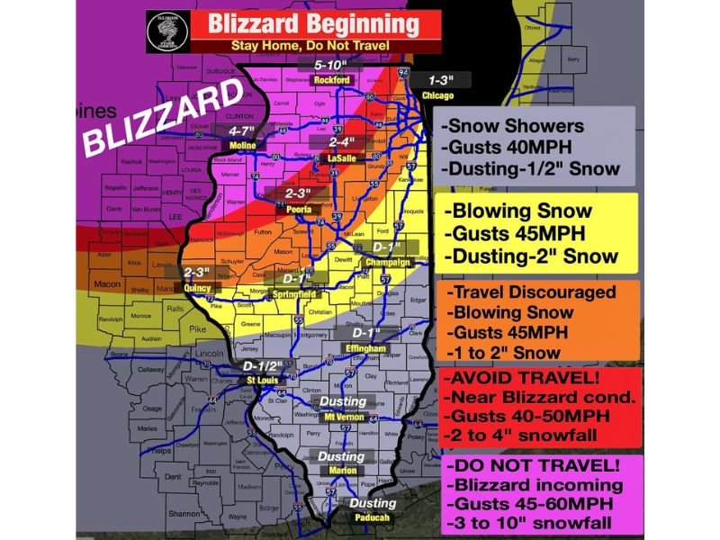
Meteorologists warn that the most severe impacts will be felt across northwestern Illinois, including Rockford and Moline, where heavy snowfall and powerful winds could quickly create near-whiteout conditions.
Officials are urging residents to avoid travel as the storm intensifies, warning that some rural roads could become nearly impossible to navigate.
Northwest Illinois Braces for Blizzard Conditions
The strongest impacts are expected across northwest Illinois, where snowfall totals between 5 and 10 inches are forecast alongside wind gusts approaching 55 mph.
These conditions will produce classic blizzard hazards including:
- Whiteout visibility
- Rapid snowdrift accumulation
- Dangerous or impossible rural travel
Cities such as Rockford, Moline, Clinton and nearby communities along the Mississippi River are expected to experience the worst conditions as strong winds whip falling snow across highways and open farmland. Emergency officials warn that travel in these areas may become extremely hazardous overnight.
Chicago Region May See Blowing Snow and Strong Winds
Further east toward the Chicago metro area, snowfall totals are expected to be lower but conditions may still become difficult due to strong winds.
Forecasters say areas from LaSalle to Chicago could receive 1 to 3 inches of snow, but wind gusts up to 45 mph may produce blowing snow and reduced visibility.
Travel impacts may include:
- Sudden visibility drops
- Slippery roadways
- blowing snow on major highways
School delays or closures could also become likely across parts of northern Illinois if conditions worsen overnight.
Central Illinois Facing Wind-Driven Snow and Slick Roads
Across central Illinois, including Peoria, Quincy and surrounding counties, snowfall totals of around 2 to 3 inches are possible. Although snowfall amounts will be lighter than in northwest Illinois, strong winds may still create dangerous driving conditions.
Wind gusts around 40–45 mph could produce blowing snow and slick highways, especially in rural areas. Residents traveling overnight are being advised to slow down and remain cautious as visibility may change rapidly.
Springfield to Champaign Seeing Lighter Snow but Strong Winds
Further south across Springfield, Champaign and Effingham, snowfall totals are expected to be lower, with many locations receiving around one inch or less.
However, strong wind gusts up to 40 mph may still cause localized travel issues. Some areas may also experience snow squalls, which can quickly reduce visibility and produce brief bursts of snowfall capable of making roads slippery.
Storm Timing and Conditions Through Monday
The winter storm is expected to continue overnight and into early Monday morning before gradually tapering off.
Meteorologists say:
- Snow should begin ending between 6 a.m. and 10 a.m. Monday
- Strong winds will likely continue through much of Monday
- Conditions should begin improving later in the afternoon
Even after snowfall ends, lingering wind gusts may continue to blow snow across open roads.
Travel Advisories and Safety Warnings Issued
Officials across parts of Illinois are urging residents to stay home and postpone travel whenever possible while the blizzard conditions develop.
Drivers who must travel are advised to:
- Reduce speed significantly
- Carry emergency supplies
- Monitor road condition updates
Because strong winds may continue through Monday, blowing snow could remain a hazard even after snowfall stops. Meteorologists say the combination of snow and wind could produce some of the most dangerous travel conditions of the season across parts of Illinois.
Stay with WaldronNews for continuing updates as this powerful blizzard spreads across Illinois overnight and into Monday morning.