
Illinois, Indiana and Michigan Face High to Very High Tornado Threat Thursday April 2 as StormNet AI Model Shows Concentrated Danger Zone From Chicago Through Indianapolis to Detroit
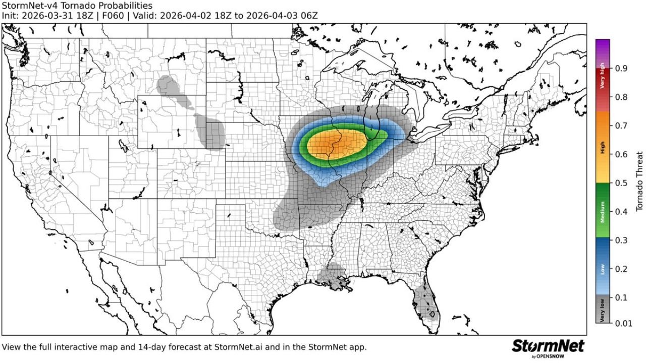
CHICAGO, ILLINOIS — An elevated and concentrated tornado threat has been detected for Thursday, April 2, 2026 by the StormNet-v4 Tornado Probability model — one of the most advanced AI-driven severe weather forecasting tools available. The forecast, initialized March 31, 2026 at 18Z and valid from April 2 at 18Z through April 3 at 06Z, shows a tight and intense bullseye of High to Very High tornado threat — represented by orange and yellow on the probability scale reaching 0.6 to 0.7 or greater — centered directly over a corridor covering northern Illinois, northern Indiana and southwestern Michigan. The core of the highest threat sits squarely over some of the most densely populated communities in the Midwest, including Chicago, South Bend, Fort Wayne, Indianapolis and Grand Rapids.
This is not a model showing a diffuse, low-confidence signal spread thinly across a wide area. This is a tightly focused, high-confidence tornado threat bullseye centered over the Chicago to Detroit corridor for Thursday afternoon and evening.
Cities in the Elevated Tornado Threat Zone Thursday
High to Very High tornado threat — 0.5 to 0.7+ on the StormNet scale:
- Illinois: Chicago, Rockford, Aurora, Joliet, Kankakee — the western anchor of the highest-risk zone
- Indiana: South Bend, Fort Wayne, Kokomo, Lafayette, Gary
- Michigan: Grand Rapids, Kalamazoo, Battle Creek — southwestern Michigan within the elevated zone
Medium tornado threat — 0.3 to 0.5:
- Illinois: Central Illinois communities south of Chicago
- Indiana: Indianapolis and surrounding communities
- Ohio: Toledo, Findlay on the eastern fringe
- Wisconsin: Milwaukee area on the northern edge
Low to very low threat — 0.1 to 0.3:
- Iowa: Eastern Iowa fringe
- Missouri: Northern Missouri
- Ohio: Western Ohio corridor
- Michigan: Lower peninsula communities beyond the core zone
What the StormNet AI Model Is Showing
The StormNet-v4 system — developed by OpenSnow — uses machine learning to analyze atmospheric patterns and detect tornado-favorable environments with a level of spatial precision that traditional probability forecasting can struggle to match. When StormNet-v4 shows an orange and yellow bullseye reaching 0.6 to 0.7 on its tornado threat scale, it is identifying an environment where the atmospheric ingredients for significant tornadoes are concentrated and well-defined.
The tightness of the probability gradient on Thursday’s map is notable. The transition from near-zero threat in the west to High threat over northern Illinois and Indiana happens over a relatively short geographic distance — meaning the model has high confidence that the tornado-favorable environment is specifically located over the Chicago to South Bend to Grand Rapids corridor, not broadly spread across a large region.
Why Thursday Is More Dangerous Than Most People Realize
The StormNet forecast initialized Tuesday afternoon confirms what multiple other models and forecasting tools have been signaling — Thursday April 2 is shaping up to be a genuinely dangerous tornado day for the Midwest, and specifically for the Chicago, northern Indiana and southwestern Michigan corridor.
What makes Thursday particularly concerning is the urban density within the highest-risk zone. Chicago is the third-largest city in the United States. South Bend, Fort Wayne, Grand Rapids, Rockford and Gary are all mid-size cities with significant populations. A tornado outbreak centered over this corridor — even if individual tornadoes are brief and relatively weak — would affect far more people than the same outbreak centered over rural farmland.
The StormNet model is not alone in flagging Thursday. Earlier forecasts from the SPC, the Nadocast tornado model and Ryan Hall Y’All’s tornado outlook have all independently identified the same geographic corridor as the focal point for Thursday’s tornado threat. When multiple independent forecasting systems converge on the same area, confidence in that threat increases significantly.
What Thursday’s Timing Means for Chicago Residents
The StormNet forecast window of 18Z April 2 through 06Z April 3 translates to approximately 1 PM CDT Thursday afternoon through 1 AM CDT Friday morning — a 12-hour window that spans the afternoon commute, the dinner hours and the overnight period for the Chicago metro area.
Thursday is not a storm that will blow through in 30 minutes and be done. The threat window is long enough that residents across Chicago, Rockford and the northern Illinois corridor should plan their entire Thursday afternoon and evening around the possibility of severe weather — not just a brief window.
What to Watch Next
- Thursday morning SPC Day 1 outlook — the formal SPC categorical and tornado probability maps issued Thursday morning will provide the clearest picture of exactly where the highest risk is concentrated
- Tornado watch issuance — expected for northern Illinois, northern Indiana and possibly southwestern Michigan Thursday afternoon
- Storm initiation timing — whether the first organized supercells fire before or after the afternoon commute in the Chicago area
- StormNet Day 1 update Thursday morning — the model will sharpen its probability estimates as the event becomes a same-day forecast
- Chicago evening storm timing — whether the worst activity arrives during the 4 PM to 8 PM window or later in the evening
Residents across Chicago, Rockford, South Bend, Fort Wayne, Gary, Kalamazoo and Grand Rapids must treat Thursday April 2 as a serious tornado threat day and have shelter plans finalized well before Thursday afternoon.
WaldronNews.com will continue tracking Thursday’s tornado threat across Illinois, Indiana and Michigan and provide live updates on watches, warnings and storm reports as the event develops.