
Illinois, Indiana and Wisconsin Residents Urged to Stay Alert as Tornado Threat Builds Thursday Evening Across Midwest
ILLINOIS, INDIANA, WISCONSIN — A developing weather system is raising concerns across parts of the Midwest as forecasters highlight two distinct areas of tornado potential heading into Thursday, with conditions expected to intensify later in the day.
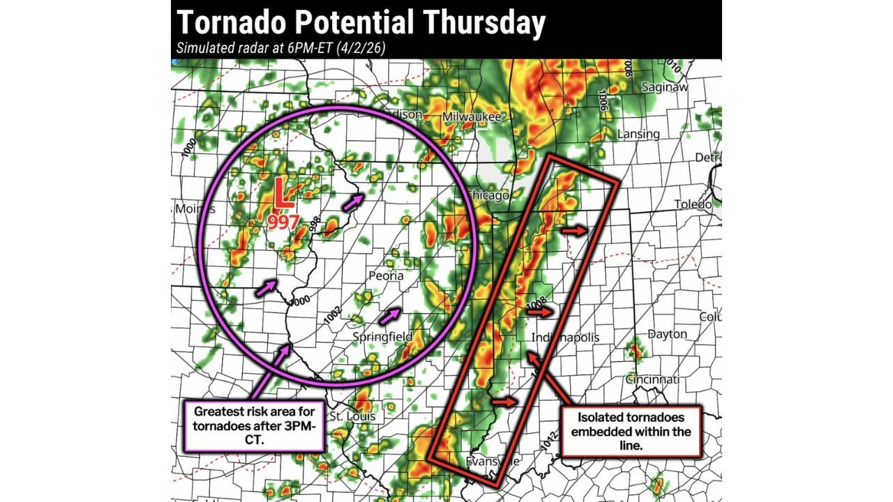
The latest simulated radar outlook for Thursday evening shows a strengthening low-pressure system centered near eastern Iowa, driving unstable conditions into surrounding states including Illinois, Wisconsin, and Indiana. While storms are expected to develop across a wide region, the timing and duration of morning rainfall will play a critical role in determining how severe conditions become.
Two Key Tornado Risk Zones Identified
Meteorological analysis points to two primary areas where tornado development could occur, each with different characteristics and timing.
Western Zone Including Eastern Iowa and Western Illinois
The first and more concerning zone stretches across eastern Iowa into western and central Illinois, including areas near Peoria and extending north toward Wisconsin.
- This region is expected to face the greatest tornado risk after 3 PM Central Time
- A deepening low-pressure system near Iowa is fueling instability
- Storms here may become more discrete and capable of producing stronger tornadoes
If afternoon heating is not disrupted by lingering morning rain, this area could quickly become the primary hotspot for severe weather escalation.
Eastern Line From Illinois Into Indiana
A second risk zone is forming along a north-south line of storms extending from northern Illinois through central Indiana, impacting cities like Chicago and Indianapolis.
- This zone is expected to produce a solid line of storms
- Tornado potential here is more isolated but still dangerous
- Tornadoes may be embedded within fast-moving storm lines, making them harder to detect
Residents in this corridor should be especially cautious, as line-embedded tornadoes can develop quickly with little warning.
Morning Rain Could Limit or Delay Severe Threat
One of the biggest uncertainties in Thursday’s setup is how long morning rain lingers across the region.
- Persistent cloud cover and rain could reduce instability
- However, if skies clear by afternoon, rapid storm intensification is likely
- Even partial clearing could be enough to trigger severe thunderstorms and tornadoes
This means conditions could shift quickly, and areas initially seeing rain may still face dangerous weather later in the day.
What Residents Should Watch Closely
People across Illinois, Indiana, Wisconsin, and eastern Iowa are being advised to stay weather-aware throughout Thursday.
Key concerns include:
- Late afternoon to evening storm intensification
- Potential for isolated tornadoes within storm lines
- Higher tornado risk in western zones if conditions align
- Rapid changes depending on morning weather trends
Preparedness Is Critical Ahead of Evening Storms
With multiple risk zones and uncertain variables in play, this setup requires heightened awareness rather than complacency.
Residents should:
- Monitor local weather updates throughout the day
- Have multiple ways to receive warnings
- Be prepared to act quickly if severe weather develops
As the system evolves, Thursday could bring a significant severe weather episode across parts of the Midwest, especially during the late afternoon and evening hours when conditions are most favorable for storm development.