
Illinois, Indiana, Missouri, and Kentucky See Sharply Different Snowfall Outcomes as Weekend Winter Storm Track Holds Steady
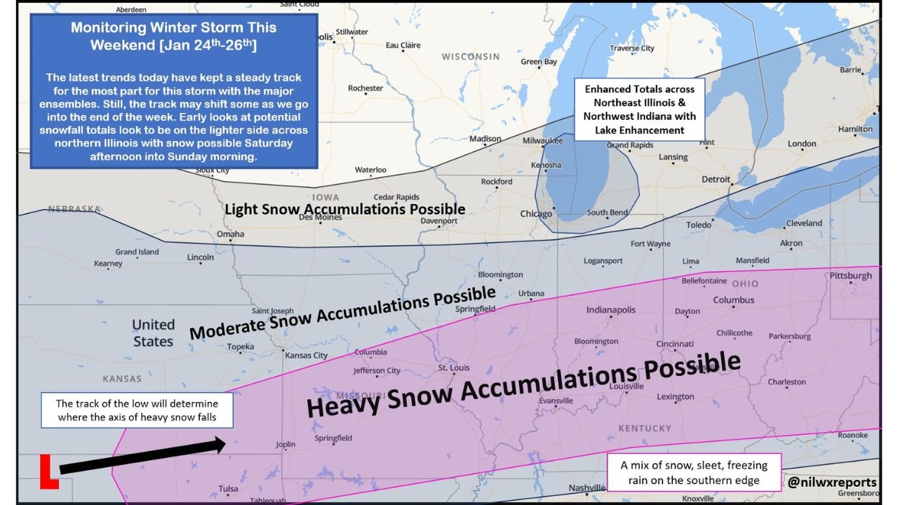
United States — The latest forecast trends show a largely steady storm track across the Midwest heading into the weekend, though meteorologists caution that some late shifts are still possible as the system approaches. Current guidance suggests lighter snowfall for northern Illinois, with moderate totals across central Illinois and potentially heavy snow across southern Illinois, highlighting a sharp north-to-south gradient in impacts.
Snow is expected to develop Saturday afternoon and continue into Sunday morning, with lingering lake-enhanced snowfall possible in some areas through Sunday afternoon.
Northern Illinois: Lighter Snow With Lake Enhancement Potential
Across northern Illinois, early projections indicate lighter snowfall totals, generally in the 1 to 3 inch range. However, areas closer to Lake Michigan, including parts of northeast Illinois, could see an additional inch or two if lake enhancement develops Saturday night.
While accumulations are expected to be modest, timing may still impact travel, especially overnight into early Sunday when road temperatures are colder.
Central Illinois: Moderate Snowfall Becoming More Likely
Forecast confidence increases across central Illinois, where 3 to 6 inches of snow is currently projected. This region sits closer to the developing deformation zone of the storm, where snowfall rates may be more persistent.
Small changes in the storm’s track could still influence totals, but central Illinois is increasingly favored for moderate, more impactful snowfall.
Southern Illinois: Heavy Snow and Mixed Precipitation Risk
The highest-impact zone remains southern Illinois, where 6 to 12 inches or more of snow is possible. This area lies near the expected axis of strongest lift, making it the most likely location for prolonged snowfall.
Along the southern edge of the storm, there is also a risk of mixed precipitation, including sleet and freezing rain, which could further complicate travel and increase the risk of power disruptions.
Why the Track Still Matters
While ensemble guidance has remained relatively consistent, forecasters note that the exact placement of the surface low will determine where the heaviest snow band ultimately sets up. A small northward or southward shift could significantly change totals for communities near the transition zones.
Updated snowfall maps are expected early tomorrow morning as higher-resolution guidance becomes available.
Timing Overview
- Snow begins: Saturday afternoon
- Heaviest impacts: Saturday night into early Sunday
- Lake-enhanced snow: Possible Saturday night through Sunday afternoon
- Lingering impacts: Sunday, especially where totals are higher
Bottom Line
This weekend’s winter storm is shaping up to be a highly regional event across Illinois, with light snow in the north, moderate accumulations centrally, and heavy snow possible in the south. While the overall track has remained steady, residents should be prepared for localized changes as the forecast continues to refine. Stay with Waldron for updated snowfall maps and timing details as this storm draws closer.