
Illinois, Indiana, Ohio, and Kentucky Brace for Powerful Storm Bringing Heavy Snow, Severe Weather, and High Winds Thursday
CHICAGO, ILLINOIS — A rapidly intensifying storm system is expected to sweep across the Midwest and Ohio Valley on Thursday, bringing heavy snow to parts of the Upper Midwest, strong winds across multiple states, and a risk of severe weather in the Ohio Valley, according to forecast models shown in the latest data.
Meteorologists say the system’s strength and speed will create sharp contrasts in weather conditions, with winter impacts on the northwest side of the storm and spring-like severe threats farther south and east.
Strong Low-Pressure System Driving Multiple Hazards
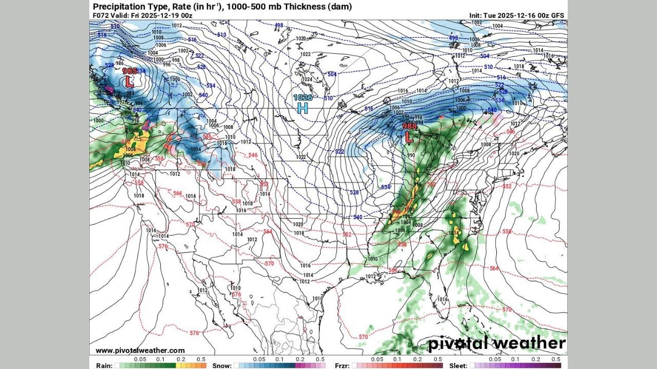
Forecast maps show a deepening low-pressure system tracking from the Plains into the Great Lakes region late Thursday. Pressure readings near 988 millibars indicate a powerful storm capable of producing high winds, heavy precipitation, and rapid weather changes over a large area.
The tight pressure gradient surrounding the system suggests widespread wind gusts, even in areas that see little precipitation.
“This is a classic high-impact setup where multiple hazards occur at the same time across different regions.”
Heavy Snow Possible Across the Upper Midwest
Northern Illinois, Wisconsin, Minnesota, and parts of Michigan could see periods of heavy snow, particularly on the colder side of the storm.
Model guidance shows snowfall developing as colder air wraps into the system, with snow bands forming northwest of the storm’s center. Travel impacts may increase quickly if snowfall rates intensify during peak hours.
Severe Weather Risk Focused on the Ohio Valley
Farther south and east, Indiana, Ohio, Kentucky, and parts of Tennessee face a conditional severe weather threat, primarily driven by strong wind energy within the storm.
While widespread tornado activity is not currently indicated, isolated damaging wind gusts remain the main concern, especially within heavier rain bands along and ahead of the storm’s cold front.
High Winds Expected Even Outside Storm Areas
Even locations that avoid snow or thunderstorms could still experience strong non-thunderstorm wind gusts Thursday due to the storm’s intensity.
Cities across the Midwest and Ohio Valley may see gusty conditions capable of downing tree limbs, causing power disruptions, and making travel difficult, particularly for high-profile vehicles.
Timing: When Conditions Will Worsen
- Thursday Morning: Snow develops across the Upper Midwest; rain spreads into the Ohio Valley
- Thursday Afternoon: Winds strengthen across the region; isolated severe storms possible
- Thursday Evening: Snow and wind continue north; rain and wind push east
What Residents Should Prepare For
- Rapidly changing road conditions
- Reduced visibility in snow and heavy rain
- Power outages due to strong winds
- Delays and disruptions to travel
Residents are encouraged to monitor updated forecasts, secure loose outdoor items, and plan travel carefully as the storm approaches.
WaldronNews.com will continue tracking this system and provide updates as new data becomes available.