
Illinois, Indiana, Ohio, Michigan Face Destructive Hail Threat Thursday With Baseball-Size Stones Possible From Chicago to Fort Wayne
ILLINOIS — A volatile weather setup is expected to unfold Thursday, March 26, bringing the potential for large to destructive hail across parts of the Midwest, with the greatest concern stretching from Illinois through Indiana into northwest Ohio and possibly southern Michigan.
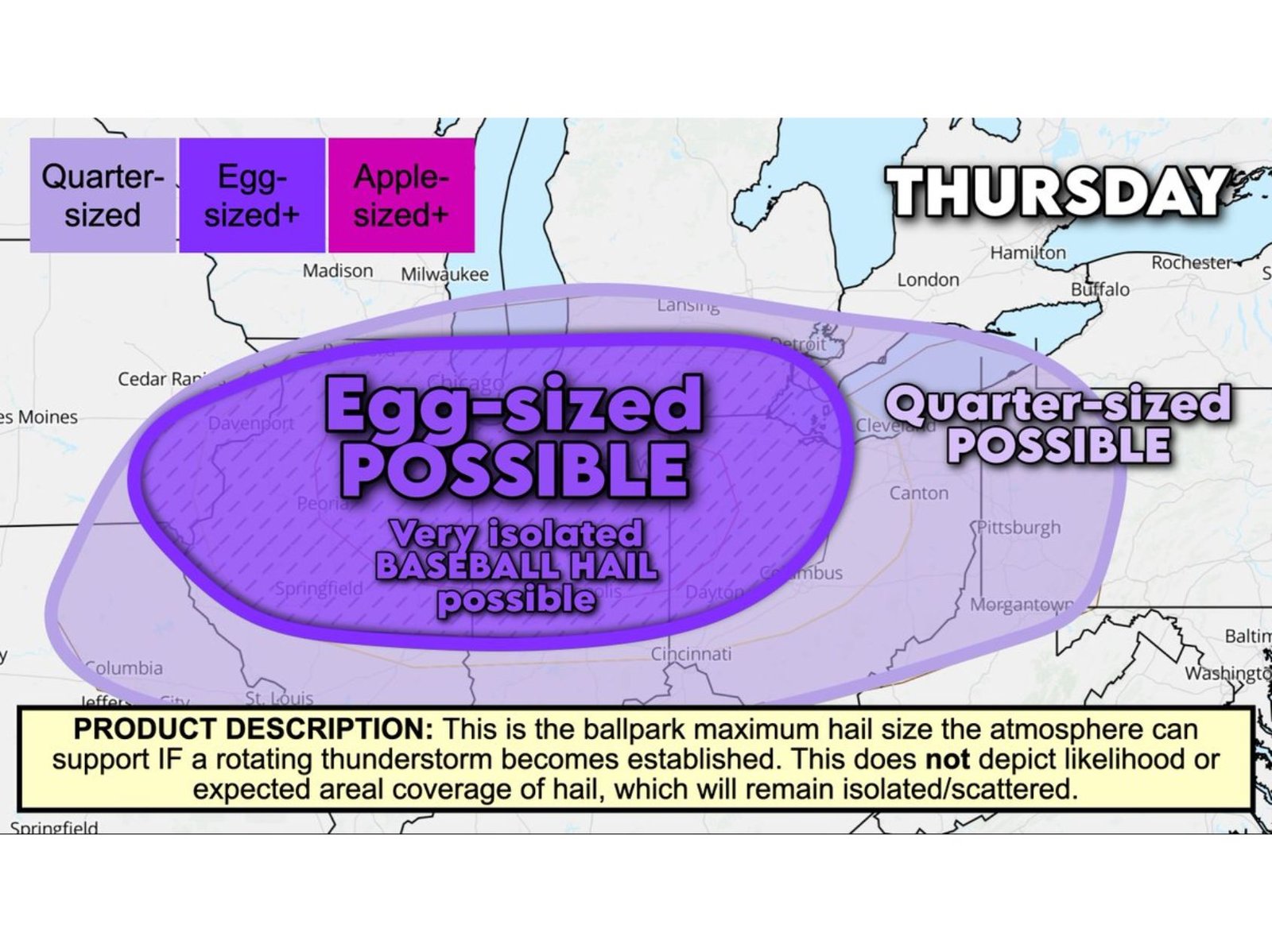
Forecast data indicates that some storms could produce hail as large as baseballs, especially during the afternoon and early evening hours, as a dynamic atmospheric environment develops along a southward-moving cold front.
Prime Zone for Large Hail Extends Across Midwest Corridor
The highest risk area for significant hail includes:
- Northern and central Illinois, including areas near Chicago
- Much of Indiana, especially northern sections
- Northwest Ohio, including regions near Toledo
- Potential extension into southern Michigan
Within this corridor, conditions appear favorable for egg-sized hail or larger, with isolated pockets capable of producing even more destructive hailstones.
Why This Setup Favors Large, Damaging Hail
The atmospheric ingredients coming together Thursday are particularly supportive of hail production.
Storms are expected to form in a humid air mass ahead of a cold front, while remaining slightly elevated above a shallow layer of cooler surface air behind the boundary. These elevated storms reduce tornado potential but enhance the risk for large hail.
Key factors include:
- Dry air in the mid-levels, allowing hailstones to grow efficiently
- Strong westerly winds, helping storms rotate and organize into supercells
- Steep lapse rates, meaning temperatures drop rapidly with height, creating an ideal environment for hail growth
Meteorologically, this combination allows supercooled water droplets to freeze onto developing hailstones, increasing their size as they cycle within storm updrafts.
Timing: Afternoon Through Evening Peak Threat
The most significant hail threat is expected during the 3 PM to 9 PM window Thursday, when storms are likely to be strongest and most capable of producing large hail.
After sunset, storms may begin to transition into lines or clusters, shifting the primary threat toward gusty winds while the hail risk gradually decreases.
Greatest Concern From South Bend to Fort Wayne
One of the most closely watched corridors includes northern Indiana, particularly from South Bend to Fort Wayne, where conditions may be most favorable for the largest hailstones.
Communities in this region could see rapidly intensifying storms capable of producing damaging hail in a short period of time.
Tornado Risk Lower but Not Zero
While tornado potential is considered limited due to the elevated nature of storms, it is not entirely zero.
For a tornado to develop, a storm would need to form on the warmer side of the boundary. However, with the cold front expected to push south quickly, most storms will likely be undercut by cooler air, reducing tornado chances.
What Residents Should Prepare For
With large hail posing a significant threat, residents across the region should be prepared for:
- Damage to vehicles, roofs, and outdoor property
- Sudden, intense storms during the afternoon and evening
- Rapid changes in conditions as storms develop
Even isolated storms could produce severe impacts, making it important to stay alert throughout the day.
Waldron News will continue tracking this developing severe weather threat and provide updates as conditions evolve across Illinois, Indiana, Ohio, and Michigan.