
Illinois, Indiana, Ohio, Michigan, Pennsylvania, and Kentucky Face Growing Risk of a Significant Winter Storm Late Next Weekend
UNITED STATES — Confidence is increasing that a widespread winter storm could impact large portions of the Midwest and Great Lakes, including Illinois, Indiana, Ohio, Michigan, Pennsylvania, and parts of Kentucky, late next weekend. Analysis of 103 different weather model simulations shows a stronger-than-usual signal for accumulating snow across the region, followed closely by dangerous Arctic cold.
While exact snowfall totals and storm placement remain uncertain at this range, forecasters say the probability-based guidance is notable and suggests this is a system worth monitoring closely.
What the Ensemble Data Is Showing Right Now
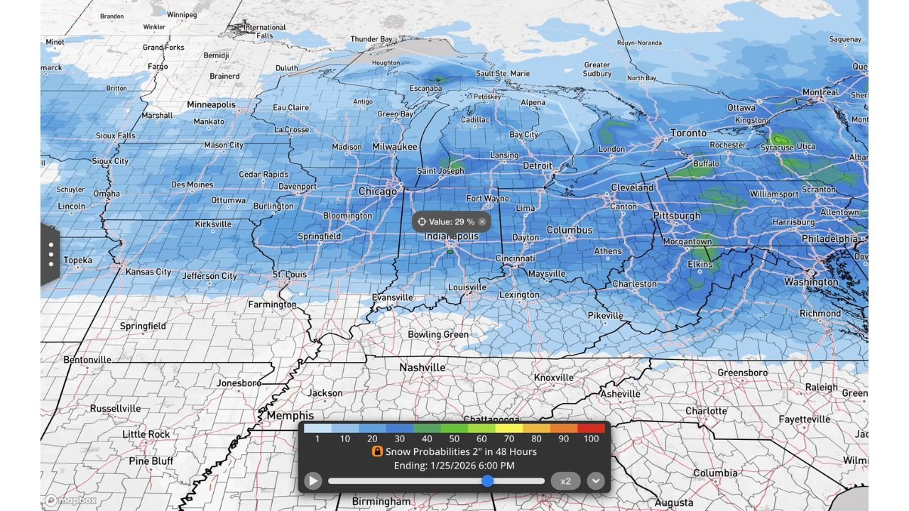
As of the latest data, meteorologists examined 103 separate forecast model runs, often referred to as “weather computers,” to assess the potential for snow late next weekend.
The results show a clear signal for a winter weather event:
- 90% of model runs indicate at least 1 inch of snow somewhere across the region
- 50% of model runs show 2 inches or more of snowfall
- 29% of model runs suggest 4 inches or more
- A small number of outlier scenarios indicate 6 inches or greater, depending on storm track and strength
These probabilities are unusually high for this lead time, signaling that the atmosphere is becoming increasingly supportive of a meaningful storm.
Regions Most at Risk Right Now
Based on current probability maps, the highest confidence for accumulating snow stretches across a broad zone from the central Plains into the Midwest and Great Lakes.
Areas currently highlighted include:
- Illinois: including Chicago and central Illinois
- Indiana: from Indianapolis northward
- Ohio: especially central and northern portions
- Michigan: lower Michigan including Detroit and surrounding areas
- Pennsylvania: western and central sections
- Kentucky: mainly northern and central regions
The snow probability gradient weakens farther south, but even those areas could see impacts if the storm track shifts.
Why Forecasters Are Paying Close Attention
Meteorologists caution against focusing too heavily on specific snowfall totals at this stage. Instead, the concern lies in the overall pattern.
Key factors raising confidence include:
- A stronger-than-normal storm signal in ensemble guidance
- Cold air already in place, allowing snow to accumulate efficiently
- A potential Arctic air surge behind the system, increasing risks even after snow ends
This setup raises the possibility of dangerous travel conditions, rapid temperature drops, and refreezing of untreated roads following the storm.
Cold Air Behind the Storm Could Increase Impacts
One of the more concerning aspects of this setup is what may follow the snow. Forecast guidance suggests another push of Arctic air arriving behind the system, which could bring very cold temperatures and wind chills to the same states affected by snowfall.
This combination increases the risk of:
- Icy road conditions lingering longer than usual
- Frozen pipes and infrastructure stress
- Increased danger for anyone without adequate heating
What Happens Next
Forecasters stress that details will change, including snowfall amounts and which states see the worst impacts. However, it is not out of line to say that a significant winter storm is possible late next weekend, especially given the strong model agreement for snow and cold.
Residents across Illinois, Indiana, Ohio, Michigan, Pennsylvania, and Kentucky are encouraged to check back frequently for updates as the forecast becomes clearer over the coming days.
Preparation and awareness now could make a major difference if this storm continues to organize as expected.