
Illinois, Indiana, Ohio, Michigan, Wisconsin, Pennsylvania, and the Central Plains Could See a Notable Arctic Air Outbreak From January 24–28 as Forecast Models Signal Extreme Cold Anomalies
UNITED STATES — New long-range forecast data is raising concern among meteorologists as ensemble guidance points toward a significant Arctic air intrusion developing across large parts of the Midwest, Great Lakes, and central United States in the January 24–28 time frame. While this cold outbreak is not expected to rival the historic extremes of 2021 or 2022, the signal for well-below-normal temperatures is strong and widespread, especially for the heart of climatological winter.
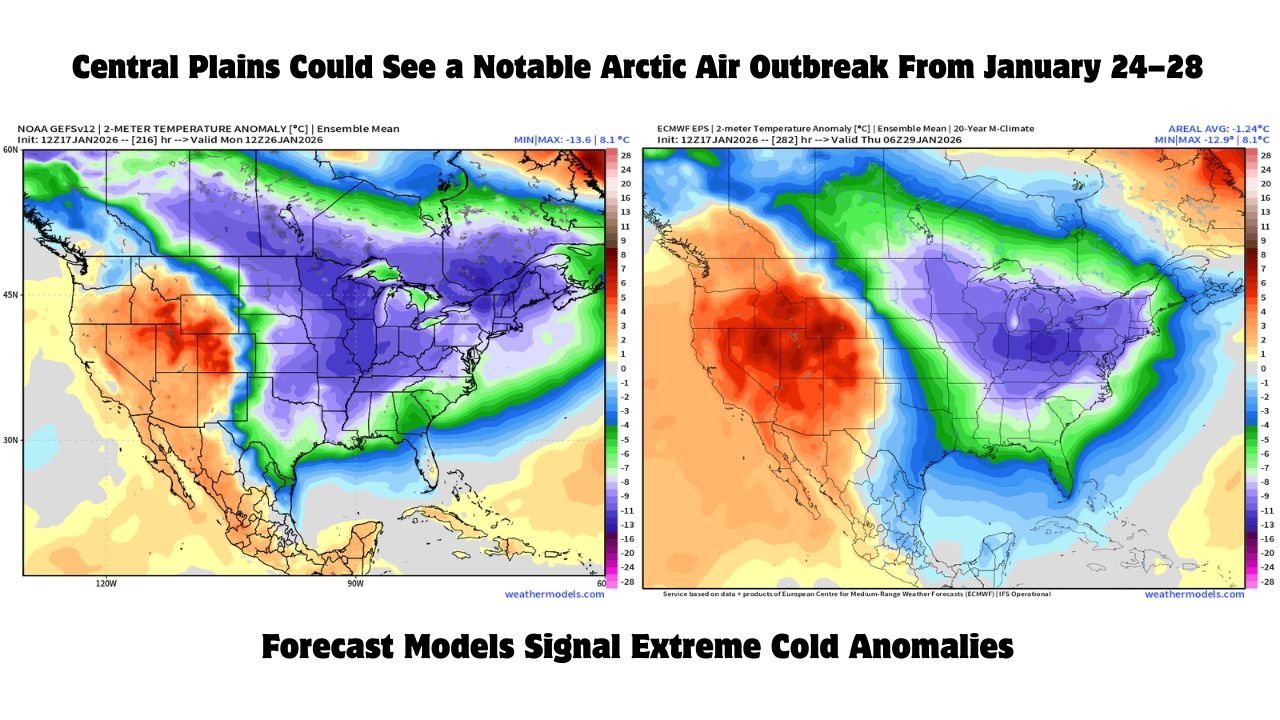
According to analysis of the 10-day GEFS (Global Ensemble Forecast System), temperature anomalies leading into late January and early February are trending 10 to 20 degrees below average, with some guidance suggesting even colder outcomes as the event draws closer.
What the Long-Range Models Are Showing
The latest ensemble data highlights a broad swath of below-normal temperatures stretching from the northern Plains through the Midwest and into the Northeast.
Key signals include:
- GEFS Day 10 showing widespread −10°F to −15°F temperature anomalies
- Earlier runs briefly indicating −15°F to −20°F anomalies in parts of the central and eastern U.S.
- EPS (European ensemble) largely supporting the colder pattern, though with slightly less intensity
- Cold centered during the peak of climatological winter, when impacts are typically magnified
Meteorologists caution that ensembles often underestimate true extremes, meaning actual temperatures could trend colder in future updates as the Arctic air mass becomes better resolved.
States Most Likely to Be Impacted
If the current pattern holds, the coldest anomalies would focus across:
- Illinois
- Indiana
- Ohio
- Michigan
- Wisconsin
- Pennsylvania
- Iowa, Missouri, and parts of the central Plains
The cold air may also push southward into portions of the Tennessee Valley and Mid-South, though moderation is expected farther south.
Not a Repeat of 2021 or 2022 — But Still Serious
Forecasters emphasize that this setup does not appear comparable to the historic Arctic outbreaks of February 2021 or December 2022, particularly across the southern Plains. However, that does not lessen its importance.
Even a moderate Arctic outbreak during late January can bring:
- Dangerous wind chills
- Frozen pipes and infrastructure strain
- Increased heating demand
- Lingering snow and ice hazards if winter storms precede the cold
The concern is heightened by the fact that cold air often deepens and expands southward late in the forecast cycle, especially once Arctic air masses are dislodged from Canada.
Why Confidence Is Increasing
Several atmospheric signals are aligning:
- Strong high-latitude blocking
- Persistent cold pooling in Canada
- Favorable jet-stream configuration for Arctic air delivery
- Consistent cold signals across multiple ensemble systems
This combination makes it increasingly difficult to dismiss the late-January cold threat as noise.
What Happens Next
Forecasters stress that details will change, including how cold it gets and exactly which states see the most severe impacts. However, the overall message is clear: a true Arctic air outbreak is possible between January 24 and January 28, and the pattern bears close watching.
Residents across the Midwest, Great Lakes, and central United States should prepare for the likelihood of very cold conditions later this month, especially if snow or ice is already on the ground when the Arctic air arrives.
Further updates are expected as models refine the strength and reach of this developing cold pattern.