
Illinois, Missouri, Arkansas and Kentucky Brace for Escalating Severe Storm Threat Tuesday as Forecast Models Increase Risk Across Midwest
UNITED STATES — Forecast models are increasingly signaling a growing severe weather threat across the central United States on Tuesday, with the latest outlooks highlighting parts of Illinois, Missouri, Arkansas, Kentucky and surrounding states as areas where strong thunderstorms could develop.
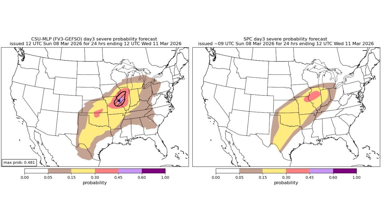
New projections from both Colorado State University’s machine-learning severe weather model and the Storm Prediction Center’s Day 3 outlook show the risk area expanding across the Midwest and lower Mississippi Valley as meteorologists monitor the evolving atmospheric setup.
Forecasters say the next 24 hours will be critical as high-resolution storm models begin to refine where the strongest storms could form.
Forecast Models Showing Increasing Severe Weather Potential
The latest probability guidance indicates an upward trend in severe weather potential for Tuesday, with risk zones stretching from the southern Plains through the Mississippi Valley and into the Midwest.
Areas currently highlighted include parts of:
- Arkansas
- Missouri
- Illinois
- Kentucky
- Tennessee
- Indiana
- Oklahoma
- Texas
The highest probabilities appear centered near the central Mississippi Valley, where conditions may become most favorable for organized thunderstorms.
Meteorologists note that the Colorado State University severe weather probability model has recently increased its outlook, signaling stronger confidence that a severe weather episode could develop.
Illinois and Missouri Among Areas of Highest Concern
The core of the projected risk currently stretches from Missouri into Illinois, where the overlap of atmospheric ingredients may support stronger storm development.
These regions sit near the northern portion of the warm sector, where:
- Warm and humid air is moving northward
- Upper-level winds are strengthening
- A frontal boundary may act as a trigger for storm development
This zone often becomes a focal point for severe thunderstorms when storm systems move across the central United States.
Multiple Hazards Possible With Developing Storms
If storms form in the most unstable part of the atmosphere Tuesday afternoon or evening, meteorologists say several severe weather hazards could develop.
Possible impacts include:
- Damaging straight-line winds
- Large hail
- Isolated tornadoes
The exact severity will depend on how storms evolve during the day, particularly whether early storms limit instability before the main system arrives.
High-Resolution Models Now Key to Refining the Forecast
Forecasters say the next stage of the forecast will rely heavily on CAMs (Convection-Allowing Models), which provide higher-resolution simulations of thunderstorm development.
These models will help determine:
- Where storms first initiate
- Whether storms organize into lines or clusters
- Which areas experience the greatest severe weather risk
Because these models focus on shorter time ranges, their guidance over the next 24 hours will be crucial for refining the severe weather outlook.
Storm Risk Extends Across Multiple States
While the most concentrated risk may develop near the Illinois–Missouri region, the broader storm zone could stretch across a large part of the central United States, including:
- Arkansas
- Missouri
- Illinois
- Kentucky
- Indiana
- Tennessee
- Oklahoma
- Texas
Residents across these states are encouraged to monitor updated forecasts as meteorologists continue analyzing new model runs.
Forecast Still Evolving Ahead of Tuesday Event
Meteorologists caution that the exact placement of the most intense storms remains uncertain, as small changes in the atmospheric setup can shift the severe weather corridor.
However, the consistent signal from multiple forecast models suggests that Tuesday could bring a notable severe weather event somewhere across the Midwest and central United States.
With model guidance trending upward in risk, forecasters say communities across Illinois, Missouri, Arkansas and Kentucky should stay alert as the forecast becomes clearer.
Stay with WaldronNews for the latest updates as meteorologists track the developing severe weather threat across the Midwest and Mississippi Valley.