
Illinois, Missouri, Arkansas, Kentucky and Indiana Face Elevated Tornado and Severe Storm Threat Tuesday as Supercells Develop Along Warm Front
UNITED STATES — A significant severe weather setup is expected to unfold Tuesday across the Great Plains and Midwest, with meteorologists warning that parts of Illinois, Missouri, Arkansas, Kentucky and Indiana could see strong thunderstorms capable of producing damaging winds, large hail and isolated tornadoes.
Forecast guidance shows storms likely developing along a warm front draped across northern Illinois, with supercells potentially forming during the evening before moving east across portions of the Midwest.
Severe Weather Risk Expands Across the Midwest
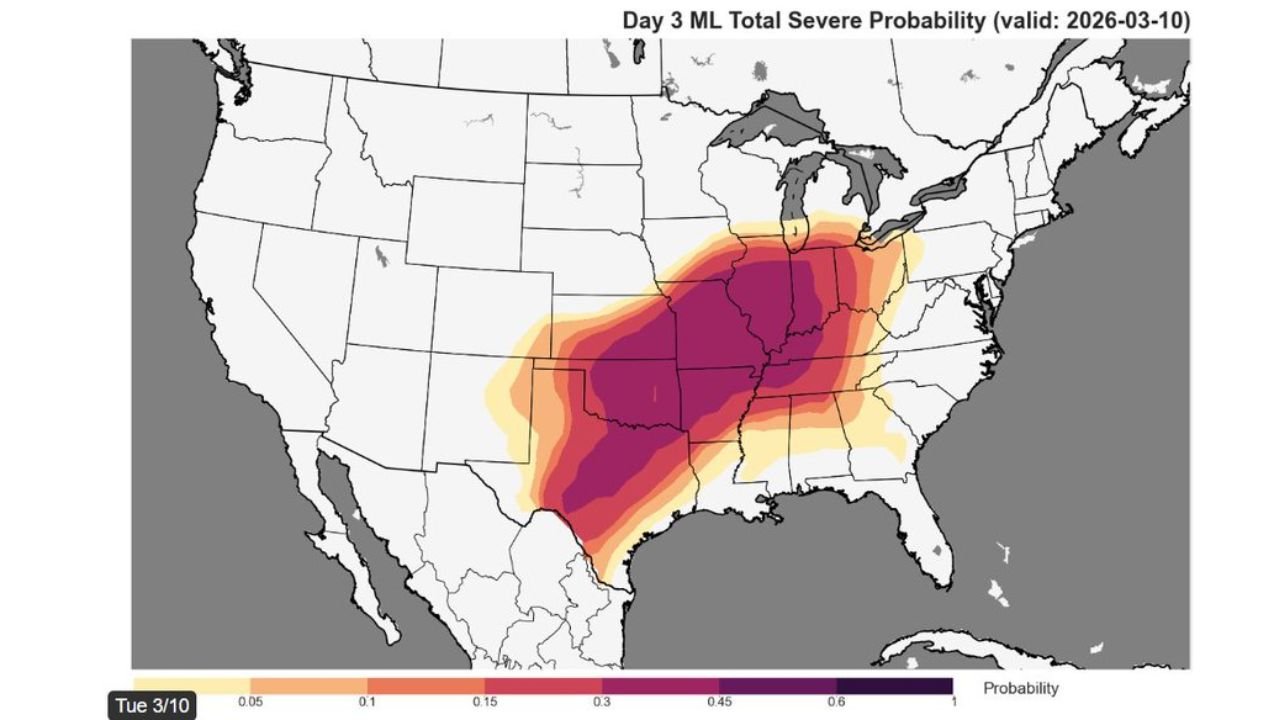
The latest severe weather outlook highlights a broad corridor of storm potential stretching from the southern Plains through the Mississippi Valley and into the Midwest.
States within the primary risk area include:
- Arkansas
- Missouri
- Illinois
- Indiana
- Kentucky
- Tennessee
- Oklahoma
- Texas
Forecast models show the highest concentration of severe weather potential centered across Missouri, Illinois and parts of Arkansas, where atmospheric ingredients are expected to overlap.
Supercells May Form Near Illinois Warm Front
Meteorologists say thunderstorms are expected to develop along a warm front positioned near northern Illinois late Tuesday evening.
This boundary will separate warmer, unstable air to the south from cooler air to the north, creating a favorable environment for rotating thunderstorms known as supercells.
Storms that develop along or just south of this boundary may become more organized as they track eastward into Indiana and Kentucky.
Atmospheric Conditions Favor Strong Storm Development
Forecast data indicates that several key ingredients for severe weather will be in place across the region Tuesday.
These include:
- Increasing instability fueled by warm and humid air
- Strengthening upper-level winds
- A lifting mechanism along the frontal boundary
- Strong wind shear capable of organizing storms
When these elements combine, they can support thunderstorms capable of producing severe weather hazards.
Large Area Could Experience Thunderstorm Activity
While the most intense storms may occur near the Missouri–Illinois region, storm activity could extend across a wide portion of the central United States.
Areas from Texas and Oklahoma northeast through Arkansas, Missouri, Illinois, Indiana and Kentucky may experience thunderstorms as the system moves eastward.
High-resolution forecast models already show clusters of storms forming across the region Tuesday afternoon and evening before spreading into the Midwest overnight.
Tornado Potential Cannot Be Ruled Out
Because supercells may develop along the warm front, meteorologists say there is potential for isolated tornadoes, particularly where wind shear is strongest.
Other threats with these storms may include:
- Damaging wind gusts
- Large hail
- Heavy rainfall
Forecasters emphasize that the exact location of the most intense storms will depend on how the warm front positions itself during the day.
Forecast Still Evolving Ahead of Tuesday Storms
Meteorologists continue monitoring the setup closely as newer model runs provide additional details about storm timing and location.
With conditions becoming increasingly favorable for organized thunderstorms, residents across Illinois, Missouri, Arkansas, Kentucky and Indiana are encouraged to stay weather-aware as Tuesday approaches.
Stay with WaldronNews for continuing updates as meteorologists track this developing severe weather event across the Midwest and Mississippi Valley.