
Illinois Residents Alerted As 4PM To Midnight Severe Storm Window Opens With Tornado Risk Along I 80 Corridor
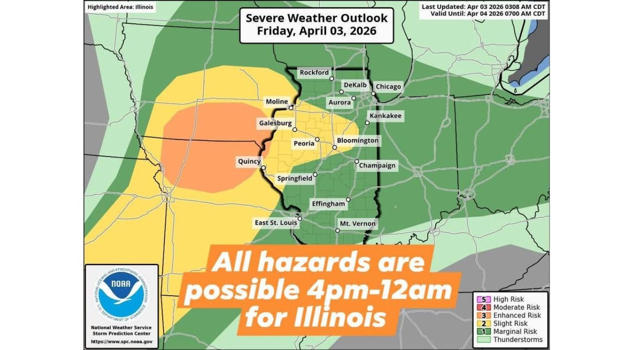
ILLINOIS — A dangerous severe weather setup is expected to unfold across Illinois this afternoon and evening, with storms developing after 3–4 PM and continuing through midnight, bringing a threat of tornadoes, damaging winds, and large hail across much of the state.
This event will evolve in phases, starting with isolated storms and transitioning into a more widespread and potentially damaging overnight system.
Storms Develop Late Afternoon Across Central Illinois
The day will begin relatively quiet, but conditions will quickly change as a warm front lifts north through central Illinois, creating an environment favorable for severe storm development.
Storms are expected to:
- Begin forming around 3–4 PM
- Initially impact central Illinois areas including Peoria, Springfield, and Bloomington
- Strengthen as they track northeast toward northern Illinois
During this phase, storms may remain more discrete, increasing the risk for:
- Tornado development
- Large hail
- Intense localized impacts
Highest Tornado Risk Along And South Of I 80
The most concerning tornado setup is expected:
- Along and south of Interstate 80
- Across central into north-central Illinois
This includes areas near:
- Peoria
- Galesburg
- Bloomington
- Springfield
These locations sit closest to the warm front boundary, where conditions are most favorable for rotating storms.
The tornado window is expected to peak between:
- 4 PM and 9 PM
During this time, storms could produce:
- Isolated to scattered tornadoes
- Some storms capable of becoming strong
Storm Mode Shifts To Damaging Winds Overnight
As the evening progresses, storms are expected to:
- Transition into a more organized line
- Spread across northern Illinois including Chicago metro
Between 9 PM and 3 AM, the primary threat will shift toward:
- Widespread damaging winds
- Heavy rainfall and embedded thunderstorms
- Reduced tornado threat, but still not zero
Northern Illinois Faces Overnight Impact
Cities and regions including:
- Chicago
- Aurora
- Rockford
- DeKalb
will likely see the main line of storms move through late tonight, with lingering showers continuing into Saturday morning.
All Hazards Remain Possible Statewide
From late afternoon through midnight, Illinois faces a full-spectrum severe weather risk, including:
- Tornadoes (highest risk earlier in the evening)
- Damaging wind gusts
- Large hail
The combination of instability, wind shear, and boundary interactions makes this a high-impact weather day across the state.
Residents Urged To Prepare Ahead Of Storms
With storms arriving during peak activity hours and continuing overnight, residents should take precautions now:
- Enable weather alerts on your phone
- Identify a safe shelter location
- Stay updated as storms develop and move quickly
A Critical Evening Across Illinois
This setup has the potential to produce rapidly intensifying storms with multiple hazards in a short time window, especially during the late afternoon and early evening hours.
Stay with WaldronNews.com for continuous updates, live storm tracking, and urgent warnings as severe weather moves across Illinois today and tonight.