
Illinois Severe Weather Alert: Tornadoes, Golf Ball-Size Hail and Damaging Winds Possible Tuesday From Peoria to Chicago and Into Indiana
ILLINOIS — A significant severe weather setup is expected to impact parts of central and northern Illinois Tuesday afternoon and evening, with meteorologists warning that conditions may support supercell thunderstorms capable of producing tornadoes, very large hail, and damaging wind gusts.
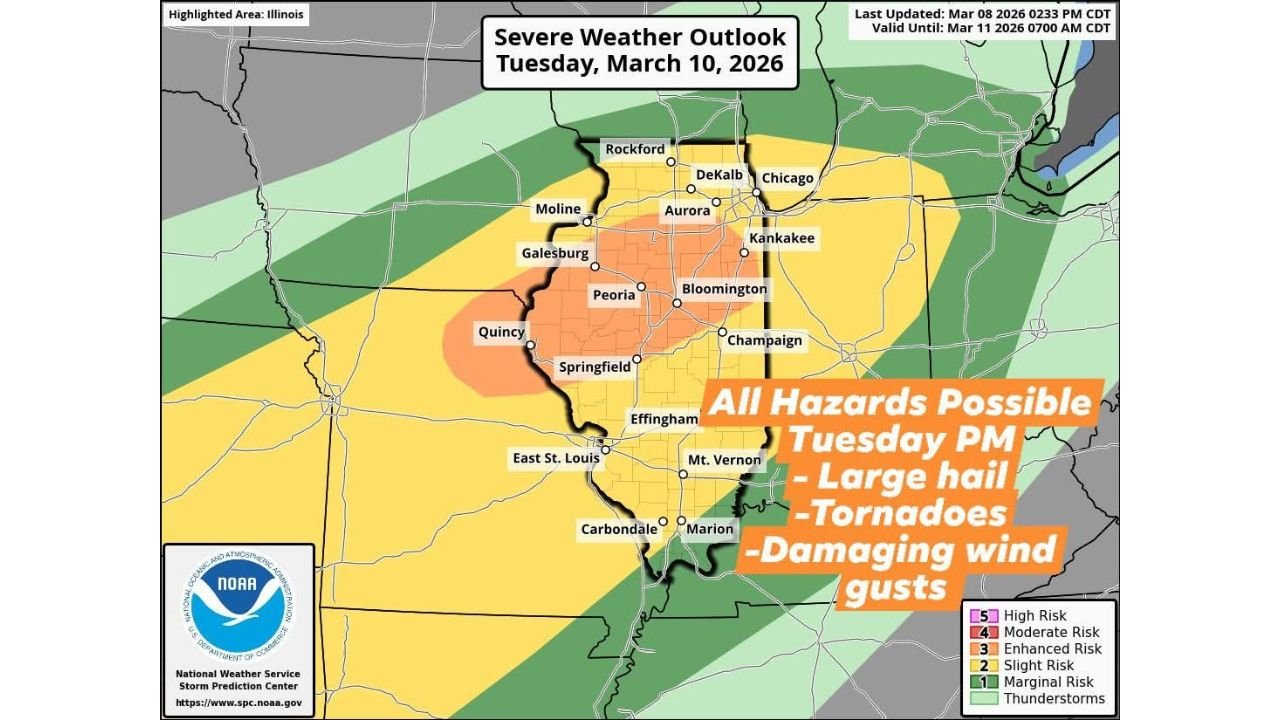
The latest afternoon forecast update indicates that severe storms are most likely between 2 PM and 8 PM Tuesday, with the greatest threat focused across central Illinois and portions of northern Illinois, particularly areas along and south of Interstate 80 extending into west-central Illinois.
Forecasters emphasize that all severe weather hazards are possible, including a potential for strong tornadoes if discrete storms develop as expected.
Supercells Expected to Develop Across Central Illinois Tuesday Afternoon
Weather models suggest that discrete supercell thunderstorms could form shortly after lunchtime Tuesday, especially across the warm sector stretching across central Illinois.
Once storms develop, they are expected to move northeast across Illinois during the afternoon and evening hours, eventually crossing into Indiana later Tuesday evening.
Cities and communities in the potential storm corridor include:
- Peoria
- Springfield
- Bloomington
- Champaign
- Aurora
- DeKalb
- Kankakee
- Rockford
- Quincy
- Galesburg
The most intense storms could occur in west-central and central Illinois, where atmospheric instability and wind shear will be strongest.
Large Hail and Tornado Threat Highlighted in Enhanced Risk Zone
Forecast outlook maps highlight an enhanced severe weather risk across portions of central Illinois, centered near cities such as Peoria, Springfield, Bloomington, and surrounding areas.
Meteorologists say storms in this region may produce:
- Very large hail, potentially golf-ball size or larger
- Damaging straight-line winds
- Isolated to potentially strong tornadoes
Because storms may remain discrete supercells rather than forming into a solid line, the tornado threat could be more pronounced in areas where rotating thunderstorms develop.
Communities within the enhanced risk zone should remain particularly alert during the mid-afternoon through early evening hours.
Lake Michigan May Reduce Severe Threat Near Chicago Lakeshore
The forecast also notes an important difference in severe weather potential near Lake Michigan.
Cooler, stable air moving inland from the lake may limit storm intensity in areas closest to the shoreline, including portions of the Chicago lakeshore region.
While thunderstorms may still occur, the risk of severe storms is expected to be lower near the lake compared with inland areas across central Illinois.
However, locations just west and southwest of Chicago could still experience severe storms if supercells maintain strength while moving northeast.
Storms Expected to Track Into Indiana by Evening
After forming across Illinois, storms are expected to track northeast into Indiana by Tuesday evening, continuing the severe weather threat across parts of the Midwest.
This movement pattern means communities in eastern Illinois and western Indiana could see storms later in the evening hours as the system progresses.
Forecasters continue to monitor how quickly storms develop and organize during the afternoon.
Forecast Still Evolving as Meteorologists Monitor Conditions
Meteorologists caution that the severe weather forecast remains an evolving situation, and additional updates may refine the location and timing of the highest threat.
Factors such as storm development timing, cloud cover, and atmospheric instability will determine how intense storms become.
Residents across central and northern Illinois are encouraged to monitor forecast updates, review severe weather safety plans, and ensure they have reliable ways to receive warnings Tuesday afternoon and evening.
With the potential for very large hail, tornadoes, and damaging winds, forecasters stress that communities should stay weather-aware as conditions develop.
Stay with WaldronNews for continued coverage and updates as meteorologists track the developing severe weather threat across Illinois and the Midwest.