
Illinois Storm Alert Issued For Peoria Springfield Bloomington And I 80 Corridor As Tornado Window Opens This Evening
ILLINOIS — A targeted tornado threat is setting up this evening across central and parts of northern Illinois, with conditions aligning along a warm front that is expected to lift north later today.
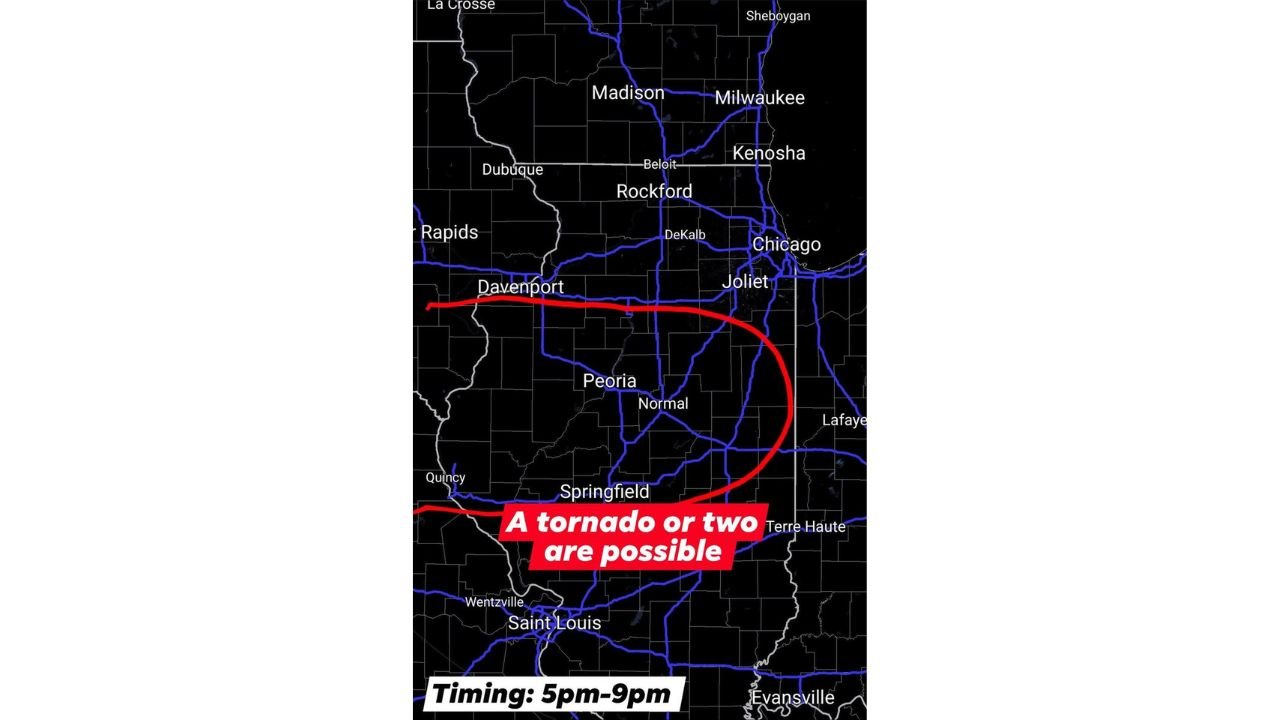
The latest update indicates that a tornado or two will be possible between 5 PM and 9 PM, especially in areas located along and south of the warm front boundary.
Tornado Risk Zone Focused Across Central Illinois
The highest concern area includes:
- Peoria
- Bloomington–Normal
- Springfield
- Areas stretching east toward the Indiana border
- South of the I-80 corridor
This zone represents the primary corridor where storms could rotate, increasing the chance for isolated tornado development.
Cities like Davenport (IA), Peoria, Normal, and Springfield sit near or just north of the outlined zone, meaning conditions will need to be closely monitored as the boundary shifts.
Critical Timing Window This Evening
The storm timing is becoming clearer:
- 5 PM to 9 PM → Peak tornado window
- Storms expected to move east to northeast
- Activity likely to intensify during the early evening hours
This timeframe is when storms may become surface-based and tap into stronger instability, especially along the advancing warm front.
Warm Front Will Control Where Tornadoes Form
A key factor in today’s setup is the position of the warm front:
- It is expected to lift north toward the I-80 corridor
- However, it may not move much farther north before a cold front sweeps in
This means:
- Areas south of the warm front = higher tornado risk
- Areas north of it = lower tornado potential but still storms
The boundary will act as a focal point for storm rotation, making it the most important feature to watch.
Strong Tornado Cannot Be Ruled Out
While the overall threat appears isolated, the environment supports:
- A tornado or two
- Possibility of a stronger tornado if storms fully organize
- Rapid changes in storm intensity as they track northeast
Even a brief tornado in this setup could become dangerous with little warning time.
Storm Movement And Expansion
Storms developing in central Illinois are expected to:
- Track toward northeast Illinois and into Indiana
- Potentially impact areas closer to Joliet and the Chicago metro later, depending on how far north instability spreads
However, the best tornado chances remain focused south of I-80.
What Residents Should Do Now
With a narrow but serious risk window:
- Stay alert during the 5–9 PM timeframe
- Have multiple ways to receive warnings
- Be ready to act quickly if warnings are issued
- Know your safe shelter location in advance
This setup is highly conditional, meaning not everyone will see severe weather — but those who do could see rapid intensification.
Stay Alert As Conditions Evolve
Forecast confidence continues to increase that central Illinois will be the focus for tornado potential this evening, with the warm front acting as the trigger zone.
Stay with WaldronNews.com for live updates, real-time storm tracking, and urgent warnings as this Illinois severe weather threat unfolds tonight.