
Illinois Storm Breakdown Reveals Why Peoria Bloomington Supercell Nearly Produced A Strong Tornado But Fell Short
ILLINOIS — A closer look at Friday’s storm across central Illinois is now revealing how a storm that had strong tornado potential ultimately failed to fully deliver, despite briefly showing signs of becoming a more dangerous supercell.
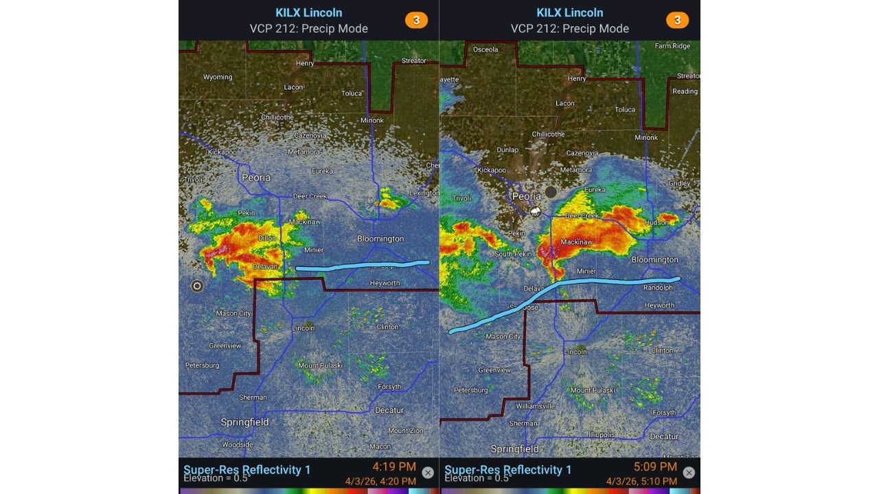
Radar and storm analysis focused on areas including Peoria, Mackinaw, Bloomington, and Springfield shows a setup that was extremely close to producing a stronger tornado event — but several key factors prevented it.
Storm Had The Right Ingredients — But Timing Was Off
The storm developed near a warm front boundary during peak heating, which is typically a favorable setup for tornadoes.
However, one major issue stood out:
- The storm did not remain on the boundary long enough
- The window for interaction with the most favorable environment was short
This limited the amount of time the storm could organize into a sustained tornado-producing supercell.
Radar Shows Strong Structure Near Mackinaw And Delavan
Radar imagery during the event showed:
- A well-defined storm core near Delavan and Mackinaw
- Strong reflectivity pushing east toward Bloomington
- Evidence of storm organization, but not long-lived rotation at the surface
The storm repeatedly tried to strengthen but struggled to maintain a clean structure.
Chaotic Storm Mergers Disrupted Tornado Formation
Another major factor was storm interference:
- Multiple smaller storms merged into the main cell
- These mergers introduced rain-cooled air into the inflow region
- The main circulation became disrupted and less efficient
Even though the storm maintained a mid-level rotation, the lower-level structure — critical for tornado formation — became inconsistent.
Inflow Was Contaminated By Cooler Air
As storms merged, they created:
- Rain-cooled outflow
- Shifts in wind direction near the surface
- A less favorable environment for strong updrafts
At times, inflow into the storm turned more easterly, which increased spin (SRH), but:
- The air being pulled in was cooler and harder to lift
- This prevented the storm from fully tightening into a tornado-producing system
Misalignment Between Storm Levels Limited Strength
One of the most critical issues observed:
- The mid-level mesocyclone (rotation aloft)
- And the low-level mesocyclone (near the ground)
These two were often not aligned properly.
As a result:
- Rotation struggled to extend downward
- The storm had to repeatedly reorganize
- Each cycle weakened its tornado potential
Storm Was Pushed Off The Boundary
The warm front — the key trigger zone — played a crucial role.
Instead of staying anchored along it:
- The storm was pushed slightly south of the boundary
- It then struggled to reconnect with the most favorable air
Once displaced, the storm lost access to its best tornado-supporting environment.
A Near-Miss Tornado Setup
Despite all the limiting factors, the analysis makes one thing clear:
This storm was very close to becoming a more significant tornado producer.
Key ingredients were present:
- Strong instability
- Favorable wind shear
- Organized storm structure at times
But the combination of:
- Short boundary interaction
- Storm mergers
- Contaminated inflow
- Structural misalignment
kept the event from escalating further.
What This Means For Future Events
This case highlights how even strong setups can fail if small details don’t align perfectly.
For central Illinois and similar regions:
- Tornado potential can hinge on minutes and miles of positioning
- Boundary placement is often the deciding factor
- Storm interactions can either enhance or completely disrupt tornado formation
Final Takeaway
Friday’s Illinois supercell serves as a reminder that severe weather forecasting is not just about ingredients — but how they come together in real time.
Stay with WaldronNews.com for expert storm breakdowns, real-time tracking, and deeper insights into the weather patterns shaping your region.