
Indiana and Much of the U.S. Expected to Run 15–20 Degrees Warmer Than Normal Before Christmas, With Colder Pattern Likely Returning After the Holiday
INDIANA — After days of brutal cold and wind chills, computer models now show a significant warm-up spreading across most of the Lower 48 states in the days leading up to Christmas, including right here in Indiana. Guidance from both the European (ECMWF) and American (GFS) ensemble models suggests large parts of the country could run about 15–20 degrees above average for several days as a milder pattern takes control.
Warm Pattern Builds Across the Lower 48
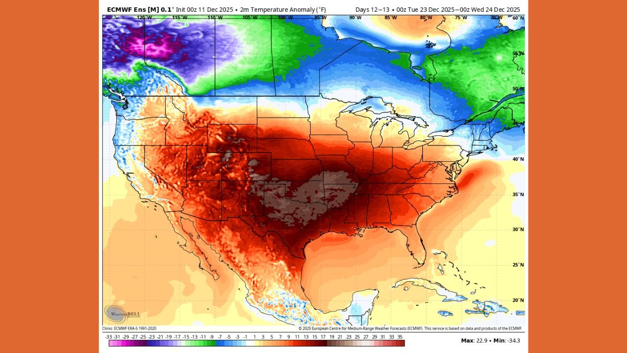
Latest anomaly maps highlight a broad zone of unseasonably warm air stretching from the Southern Plains through the Midwest, Ohio Valley and into the East during the December 23–24 time frame.
Instead of deep blues and purples (signaling colder-than-normal air), the charts are dominated by deep red and orange shades, a clear sign that temperatures will be running well above what is typical for late December.
For Indiana and surrounding states, this pattern usually means:
- Daytime highs running a full category warmer than normal, with many locations climbing well above their usual late-December averages.
- Milder nights, reducing the risk of dangerous wind chills that recently pushed into the negatives across the region.
- A break from frequent snow showers, as warmer air and a more west-to-east (zonal) flow tend to favor rain or dry breaks instead of widespread Arctic outbreaks.
In simple terms, it will feel “warm” by winter standards across a huge portion of the country as we head into Christmas week.
What the Weather Models Are Showing
Meteorologists are paying close attention to two major ensemble model suites:
- The ECMWF ensemble paints a strong warm anomaly centered over the central U.S., with warmth spreading into the Great Lakes and Ohio Valley.
- The GFS ensemble largely agrees, also showing widespread above-normal temperatures from the Rockies to the East Coast, including Indiana.
Both sets of guidance indicate that the core of the warmth may sit from Texas through the central Plains and into the Midwest, where departures from normal could reach or even exceed 20°F for a time.
At the same time, the maps show colder-than-normal air bottled up across western Canada and far northern parts of the continent. That cold reservoir is important because it hints that winter is not done yet—it’s simply being held to the north temporarily.
Could This Warmth Bring Severe Weather?
A warmer pattern in December can sometimes raise questions about severe thunderstorms, especially across the South and lower Mississippi Valley.
Right now, guidance suggests a strong west-to-east (zonal) flow from the Pacific, which tends to:
- Push milder Pacific air across the country instead of direct Arctic blasts
- Limit the number of classic, high-end severe weather setups, since strong north–south clashes between air masses are less frequent
Forecasters caution, however, that long-range predictability is still poor. A few stronger disturbances could still organize lines of showers or storms, particularly over the southern and central U.S., but no specific major severe outbreak is locked in at this range.
Warm-Up Likely Short-Lived as Colder Air Lurks for Late December and January
While many residents will welcome a break from deep winter cold, this warm stretch is not expected to last indefinitely.
Model guidance is already hinting that:
- The pattern may begin to shift back toward colder conditions sometime around or just after Christmas, as blocking and jet-stream features reorganize.
- Colder air from Canada could gradually slide south again heading into late December and early January, bringing temperatures back to or below normal for Indiana and much of the Midwest.
In other words, this is a temporary thaw, not the end of winter. Roads, pipes and infrastructure that just endured extreme cold will get a short reprieve, but residents should avoid packing away winter gear or assuming the harsh conditions won’t return.
What Hoosiers Should Expect and How to Prepare
For Indiana residents, the upcoming pattern means:
- More comfortable daytime conditions for last-minute holiday shopping and travel.
- Potential for melting of recent snow and ice, which could improve some roadways but may also lead to slick spots at night when temperatures drop back near freezing.
- A good window to check homes, vehicles and emergency supplies before the next surge of colder air arrives late in the month.
As always with long-range forecasts, details can and will change, especially on exact temperatures and the timing of the eventual cooldown. Staying updated over the next week will be important for anyone with major holiday travel plans.
For continuing updates on winter temperature swings, travel impacts and local Indiana weather headlines, keep checking WaldronNews.com for the latest coverage and forecasts.