
Indiana and Ohio Bracing for Sunday Night Line of Hail and 50+ MPH Wind Gusts From Bloomington to Indianapolis, Dayton and Columbus
INDIANAPOLIS, IN — A line of strong thunderstorms is expected to sweep across central Indiana and Ohio late Sunday evening, bringing the potential for hailers and gusty winds as storms organize ahead of an advancing system.
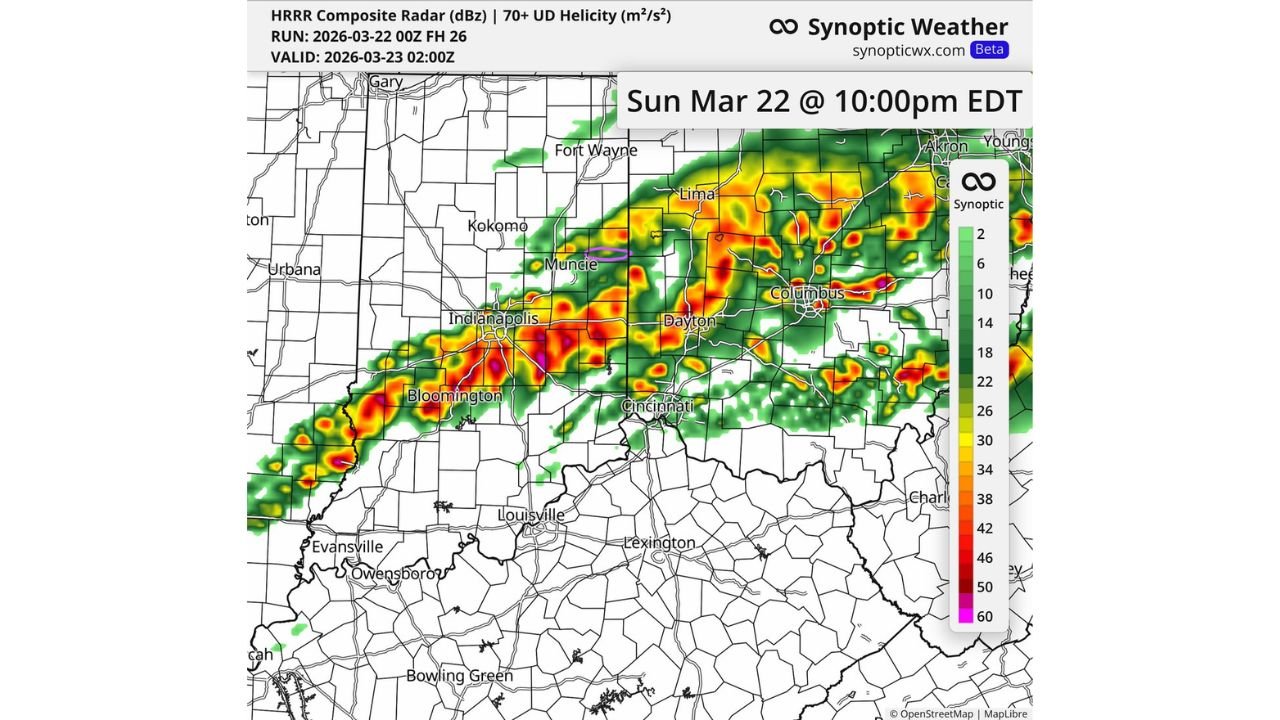
High-resolution model guidance valid around 10:00 PM EDT Sunday (March 22) shows a consolidated band of storms stretching from southern Indiana through central Indiana and into western and central Ohio.
Storm Line Targets Central Indiana
The most intense segment of the line appears to move through:
- Bloomington
- Indianapolis
- Muncie
Radar projections indicate embedded stronger cores within the line capable of producing locally heavy downpours and hail.
Wind gusts in the strongest cells could reach 45 to 55 mph, particularly where bowing segments develop along the line.
Ohio Impact: Dayton to Columbus
As storms push east, the line is projected to impact:
- Dayton
- Cincinnati (northern suburbs)
- Columbus
- Areas west toward Lima
The model highlights pockets of enhanced rotation embedded within the line, particularly near central Ohio. While the primary threat appears to be damaging wind gusts and hail, isolated stronger storm cores cannot be ruled out.
Timing: Late Evening Push
Based on current projections:
- Storms enter southwestern and central Indiana during the late evening.
- The line moves into western Ohio by mid-to-late evening.
- Central Ohio, including Columbus, sees impacts near or shortly after 10 PM EDT.
Forecasters are also monitoring trends for slightly earlier development, which could shift timing forward.
Primary Threats
Residents across central Indiana and Ohio should prepare for:
- Wind gusts up to 50+ mph
- Small to possibly marginally severe hail
- Frequent lightning
- Brief heavy rainfall reducing visibility
While widespread severe weather is not currently expected, the organized nature of the line suggests pockets of stronger wind could occur.
South of the Main Line
Areas farther south — including Louisville and much of central Kentucky — appear to remain largely outside the strongest storm corridor at this time.
The focus remains primarily along and north of the Ohio River, centered across Indiana and Ohio.
Stay Weather Aware
Evening severe weather can catch communities off guard, especially as many people are indoors or traveling home. Residents are encouraged to:
- Keep mobile alerts enabled
- Secure loose outdoor objects
- Monitor updated forecasts as trends evolve
Storm intensity and placement can shift as new data comes in throughout the afternoon.
Stay with WaldronNews.com for continuing updates on Sunday evening’s severe weather threat across Indiana and Ohio.