
Indiana and Ohio Face a Slippery Friday Morning as Snow Spreads East and Freezing Drizzle Targets Indianapolis to Bloomington
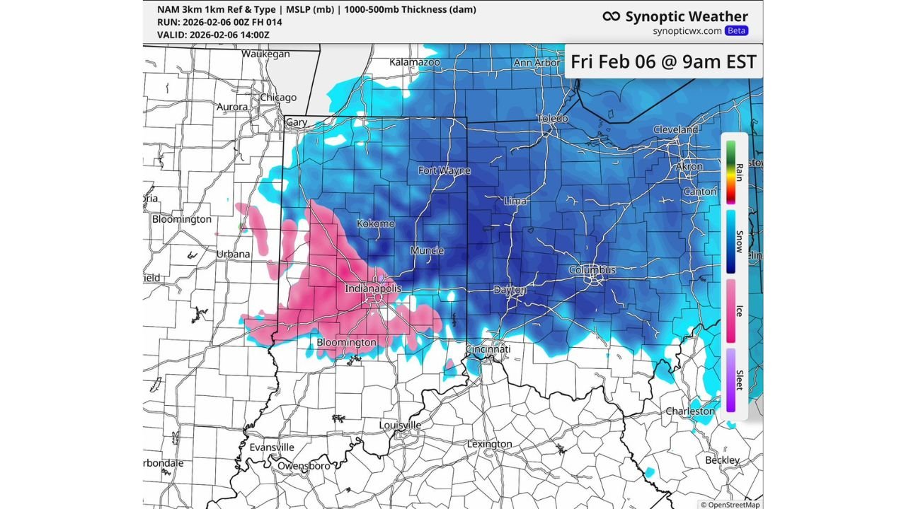
UNITED STATES — A messy Friday morning commute is shaping up across parts of the Midwest as snow expands across Indiana and Ohio while a stripe of freezing drizzle/freezing rain threatens to ice up roads—especially in and around central Indiana. The snapshot shown is centered on Friday, Feb. 6 at 9 a.m. EST, and it highlights a classic “two-problem” setup: widespread snow in colder air, and a narrow but dangerous ice zone where temperatures hover near freezing.
What the radar-type map is showing for Friday morning
The model depiction shows broad snow coverage (blue shading) across much of:
- Indiana (including northern and central portions)
- Ohio (including western and central areas)
- Extending into parts of southern Michigan (toward areas near Ann Arbor)
At the same time, a pink band marked as ice/freezing rain/freezing drizzle cuts across central and southern Indiana, brushing the Indianapolis metro and areas down toward Bloomington. That’s the piece most likely to turn “just snowy” travel into slick, icy travel in a hurry.
Indiana: Snow north and east, ice risk near Indianapolis and Bloomington
Across Indiana, the map places snow over a wide swath, including areas near:
- Gary
- Kokomo
- Muncie
- Fort Wayne
But the highest-impact concern is the freezing drizzle/freezing rain zone that appears to extend through parts of:
- Indianapolis
- Bloomington
- Nearby communities along and south of the I-70 corridor
Freezing drizzle is especially tricky because it can look minor on radar, yet still coat roads, bridges, and untreated surfaces with a thin glaze that causes sudden sliding—especially during stop-and-go traffic.
Ohio: Widespread snow from Toledo to Columbus, with slick travel likely
In Ohio, the snow coverage is extensive and includes several major corridors and population centers:
- Toledo
- Lima
- Dayton
- Columbus
- Farther northeast toward Cleveland, Akron, and Canton
This points to a broad, steady snow problem for Ohio commuters, where reduced visibility and snow-covered roads can slow traffic quickly. Even if totals stay modest in spots, the timing (morning drive) raises the disruption risk.
Cincinnati area: close to the rain/snow line
The map also suggests the southern edge of the wintry precipitation is close to the Ohio River valley, with Cincinnati near the transition zone. That can mean:
- Periods of snow
- A brief wintry mix
- Rapid changes in road conditions depending on exact temperature and precipitation intensity
In these boundary setups, small shifts can change whether roads are “wet” or “ice-slick” during the same commute window.
Why the morning commute could get rough fast
This is the kind of pattern that creates problems even without a major storm total because:
- Snow reduces traction immediately, especially on untreated side streets
- Freezing drizzle can glaze roads quickly, sometimes faster than plows can keep up
- Bridges and overpasses ice first, and they often catch drivers off guard
- Morning temperatures are usually at their coldest, increasing the odds that precipitation sticks
Commute guidance for Friday morning
If you’re traveling in Indiana or Ohio Friday morning, especially near Indianapolis, Bloomington, Dayton, Columbus, or Toledo, plan for delays and slick conditions.
Smart steps before heading out:
- Leave extra time and reduce speed early (don’t wait until you hit a slick stretch)
- Assume ramps, bridges, and shaded roads are worse than main highways
- Increase following distance and avoid sudden braking
- If you encounter freezing drizzle, treat it like ice—even if it looks light
What to watch for in real time
Because the worst travel conditions often depend on where the ice band sets up, watch for:
- Temps hovering near 32°F
- Reports of “light drizzle” but rapidly worsening roads
- A change from wet pavement to a glassy sheen on overpasses
If the pink “ice” zone holds over central Indiana during peak drive time, that’s where the most abrupt travel issues are likely.
If you’re in Indiana or Ohio this morning, are you seeing steady snow, or is freezing drizzle starting to glaze roads? Share what you’re dealing with, and keep following winter weather updates on WaldronNews.com.