
Indiana and Ohio Face Increasing Risk of Strong to Severe Storms This Afternoon as Thunderstorm Cluster Moves East From Illinois Bringing 50 to 60 mph Wind Gusts Toward Fort Wayne, Indianapolis, Dayton and Toledo
INDIANAPOLIS, INDIANA — A cluster of thunderstorms currently moving through Illinois and Northern Indiana is gradually tracking eastward this afternoon — and the risk of strong to severe storms is increasing for a wide swath of Indiana and western Ohio. Damaging wind gusts of 50 to 60 mph or greater and isolated large hail are both possible as the storm cluster pushes east through the afternoon hours. A severe thunderstorm watch expansion is also being monitored — meaning the formal watch zone that currently covers portions of the region could be extended further east into Indiana and Ohio as the storm activity develops.
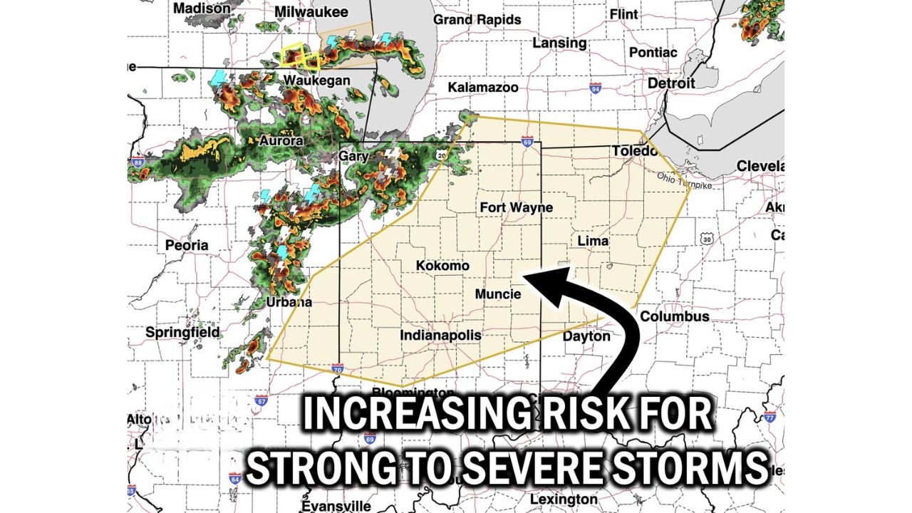
The Clarity Weather radar map shows the active storm cluster currently near Aurora, Waukegan, Gary and Urbana, Illinois, with the severe thunderstorm watch zone — outlined in yellow — already covering a broad area from Fort Wayne and Kokomo south through Indianapolis and east toward Dayton, Lima and Toledo.
Cities and Areas at Risk This Afternoon
Currently in the Severe Thunderstorm Watch zone:
- Indiana: Fort Wayne, Kokomo, Muncie, Indianapolis, Bloomington
- Ohio: Dayton, Lima, Toledo and the Ohio Turnpike corridor
- Fringe areas: Columbus, Ohio on the eastern edge of the watch zone
Storm cluster currently producing activity near:
- Illinois/Indiana border: Gary, Aurora, Waukegan — active storm cells with lightning and heavy rain
- Northern Illinois: Urbana, Peoria corridor — where the southern portion of the storm cluster is generating intense rainfall
Expansion watch — communities that may be added:
- Eastern Indiana and western Ohio — if the severe thunderstorm watch is expanded eastward as storm activity increases, communities like Muncie, Dayton and Lima could see watch upgrades
- Michigan fringe: Kalamazoo and Grand Rapids on the northern edge of the potential expansion zone
What Is Happening Right Now and What Comes Next
The storm cluster is a disorganized but active collection of thunderstorm cells that has been producing strong winds, heavy rain and lightning across Illinois and is now pushing into northern Indiana. As these storms move east through the afternoon, they will be encountering a more favorable atmospheric environment — meaning individual cells could strengthen and organize as they track toward Fort Wayne, Kokomo and the broader Indiana corridor.
The 50 to 60 mph or greater wind gust threat is the primary concern. Wind gusts at this level are capable of snapping tree limbs, downing power lines, flipping lightweight vehicles and causing damage to structures. In urban areas like Indianapolis and Dayton, these winds can create widespread power outages and dangerous road conditions from fallen debris very quickly.
Isolated large hail is also possible within the strongest cells — while not the primary concern for this event, hail accompanying the strongest wind-producing cells could add to property damage in communities that take a direct hit.
Watch Expansion — Why It Matters for Indiana and Ohio
The potential expansion of the severe thunderstorm watch eastward is important for residents of central and eastern Indiana and western Ohio to understand. A severe thunderstorm watch means conditions are favorable for severe thunderstorms to develop across the watch area — it is not a warning for an imminent storm, but it is a signal to stay alert, have a plan and monitor weather updates closely.
If the watch is expanded to include Dayton, Columbus and the I-70 corridor in Ohio, residents in those communities will have less preparation time as the storm cluster is already moving in their direction this afternoon. The time to prepare is now — not after the watch expansion is announced.
Timing for the Afternoon Storm Threat
The storm cluster is tracking eastward and is expected to continue doing so through the afternoon hours. Based on current position and motion:
- Right now — active storm cells near Gary, Aurora and the Illinois-Indiana border producing strong winds and heavy rain
- This afternoon — storm activity spreading eastward into central Indiana including Kokomo, Muncie and the Fort Wayne corridor
- Late afternoon and evening — the cluster continuing east toward Indianapolis, Dayton and the Toledo area as evening approaches
- Watch expansion — possible at any point this afternoon if storm activity intensifies beyond current expectations
What to Watch Next
- Severe thunderstorm watch expansion — whether the watch zone is extended eastward into central Ohio and additional Indiana counties this afternoon
- Wind gust reports from northern Indiana communities as the storm cluster crosses the state line
- Indianapolis timing — when the storm cluster reaches the metro area and how organized it is at that point
- Dayton and Toledo — the eastern extent of the current watch zone and where the storm cluster will eventually arrive late afternoon and evening
- Lightning safety — with active thunderstorms tracking across the region, anyone outdoors in Indiana or western Ohio this afternoon should move indoors immediately at the first sign of thunder
Residents across Fort Wayne, Kokomo, Muncie, Indianapolis, Dayton, Lima and Toledo should stay weather-aware throughout this afternoon, keep weather alerts active on mobile devices and be prepared to take shelter quickly if a severe thunderstorm warning is issued for their county.
WaldronNews.com will continue monitoring the storm cluster and provide live updates on watch expansions, severe weather warnings and wind reports across Indiana and Ohio through the afternoon and evening.