
Indiana, Illinois and the Midwest Brace for Dangerous Weekend Cold as Polar Vortex Drives Wind Chills Toward –40°F
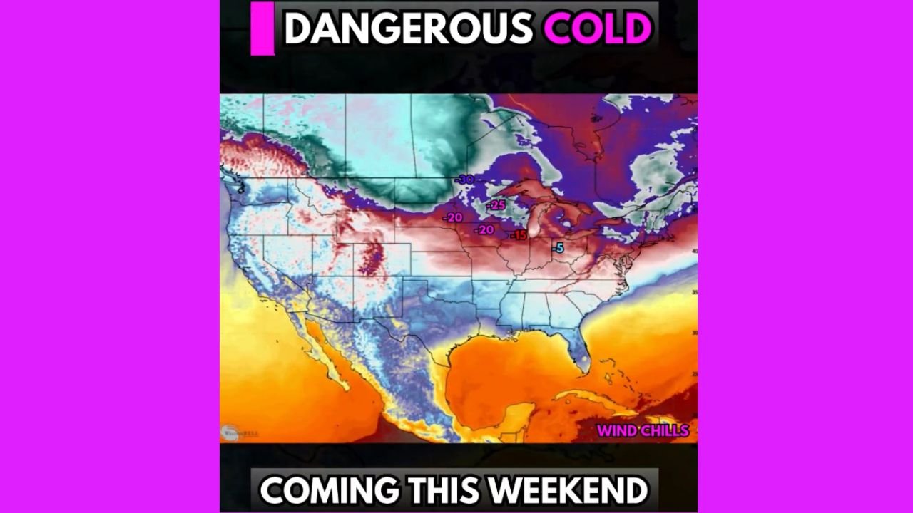
WALDRON, INDIANA – A bitter blast of Arctic air is set to plunge across Indiana, Illinois and much of the Midwest this weekend, sending temperatures into the single digits and pushing wind chills to life-threatening levels that could approach 40 degrees below zero in some locations.
Forecasters say a lobe of the polar vortex will dive south out of Canada, unlocking the coldest air of the season so far and spreading it from the Northern Plains through the Great Lakes and into the Northeast. The worst of the cold is expected from Saturday through at least Tuesday, before a gradual thaw and potential pre-Christmas warm-up.
How Cold Will It Get in Indiana and the Midwest?
Behind a powerful Arctic front, temperatures will crash quickly late Saturday into Sunday.
- Many communities in Indiana, Illinois, Iowa, Wisconsin, Minnesota and Michigan will see air temperatures fall into the single digits or below zero.
- When combined with strong northwest winds, wind chills could drop to –20°F to –40°F at times across the Upper Midwest and western Great Lakes.
Even during the daytime, it may feel well below zero, especially on Sunday and Monday, making it dangerous to be outside for more than a few minutes without proper protection.
Why This Polar Vortex Shot Is So Dangerous
This outbreak is being driven by a lobe of the polar vortex dipping south over the central United States, allowing extremely cold air from the Arctic to spill into the Lower 48.
As the cold high-pressure system settles in, pressure differences between the Arctic air mass and milder conditions to the south will generate strong, gusty winds. These winds are what turn already-frigid air temperatures into dangerous wind chills that can cause frostbite in as little as 10–20 minutes on exposed skin.
Travel impacts are likely, even without heavy snow, as blowing snow, icy roads and the extreme cold itself can lead to vehicle problems and hazardous conditions for anyone stranded.
What About Snow and Ice?
This event looks to be more of a cold outbreak than a major snowstorm, but snow showers and light accumulations are still possible:
- Lake-effect snow bands may set up downwind of the Great Lakes, targeting parts of Michigan, Indiana, Ohio and western New York with bursts of heavier snow and reduced visibility.
- Light snow or flurries could accompany the leading Arctic front as it sweeps through the Midwest and into the Northeast.
Even a coating of snow on top of rapidly freezing roads can make for slick, hazardous travel Saturday night through Monday, especially in rural areas.
How Long Will the Extreme Cold Last?
Current projections suggest the core of the Arctic air will remain over the central and eastern U.S. through at least Tuesday, keeping highs well below normal and overnight lows in the single digits or below zero across much of the region.
After mid-week, computer models hint at a gradual warm-up heading into Christmas week. Temperatures may climb closer to, or even a bit above, seasonal averages just before the holiday, but the exact timing and intensity of that rebound are still uncertain.
For now, residents should plan for several days of bitter cold before any noticeable relief arrives.
Safety Tips for Indiana Families Facing the Cold
With wind chills dropping to dangerous levels, basic cold-weather precautions become critical:
- Limit time outdoors, especially for children, older adults and pets.
- Dress in layers, including hats, scarves and insulated gloves.
- Cover exposed skin, as frostbite can develop quickly when wind chills fall below –20°F.
- Check on neighbors, particularly those who are elderly or live alone.
- Ensure space heaters, fireplaces and generators are used safely and never in enclosed spaces where deadly carbon monoxide can build up.
Local emergency managers urge people to prepare their vehicles as well, keeping gas tanks at least half-full, packing blankets, extra hats and gloves, and carrying a charged phone in case of a breakdown.
What This Means for Waldron and Shelby County
Here in Waldron and the surrounding communities of Shelby County, residents can expect:
- A sharp temperature drop late Saturday.
- Windy, brutally cold conditions Sunday and Monday, with sub-zero wind chills likely.
- Slick spots on untreated roads and parking lots, even if snowfall amounts stay light.
Schools, sports leagues and outdoor events may need to adjust schedules if the cold and wind become too extreme for safe activities.
Stay Weather-Ready With WaldronNews.com
This Arctic blast will be one of the most dangerous cold snaps of the season so far for Indiana, Illinois and the wider Midwest. Forecast details can still shift, especially regarding wind speeds, lake-effect snow bands and the timing of next week’s warm-up.
For updated temperature forecasts, wind chill maps and any advisories or warnings issued for our area, keep checking WaldronNews.com. We’ll continue to track the polar vortex, the potential for additional snow, and what this pattern could mean for Christmas week weather across Indiana and the region.