
Indiana, Michigan, Ohio, Kentucky, Tennessee and the Eastern U.S. Hit by Arctic Cold Blast, Lake-Effect Snow and Uncertain Weekend Winter Threat
UNITED STATES — A strong arctic cold front sweeping across the eastern half of the country is driving much colder temperatures, lake-effect snow, blowing snow, and increasing winter weather concerns from the Great Lakes through the Midwest and into the Southeast as the weekend approaches.
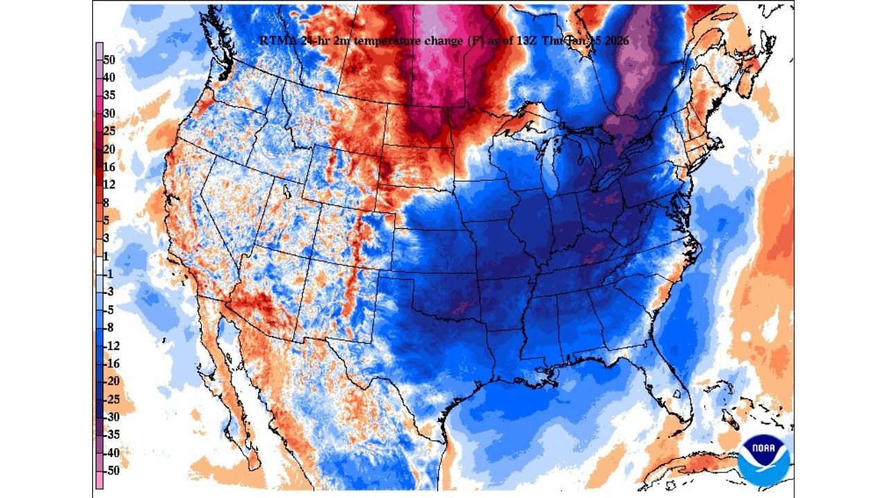
Many areas woke up to temperatures 15 to 30 degrees colder than just 24 hours earlier, setting the stage for hazardous travel, reduced visibility, and accumulating snow in several states.
Cold air continues pushing south, and forecasters say impacts will stretch across multiple regions through Saturday and into early Sunday.
Sharp Temperature Drop Follows Powerful Cold Front
Behind the front, much colder air has surged into the eastern U.S., producing one of the sharpest temperature drops of the season so far.
- Indiana, Ohio, Michigan, Kentucky, Tennessee, and the Mid-Atlantic saw rapid cooling overnight
- Many locations are 15–30°F colder than yesterday
- Gusty winds are making conditions feel even colder, especially overnight and early morning
This cold air is helping fuel snow showers, blowing snow, and lake-effect bands.
Heavy Lake-Effect Snow Slams Northern Indiana and Southern Michigan
The most significant snowfall over the past 24 hours occurred in northern Indiana and southern Michigan, where persistent lake-effect snow developed off Lake Michigan.
Observed snowfall totals include:
- 4 to 6+ inches from Saint Joseph, Michigan to Marion, Indiana
- Over 16 inches in South Bend, Indiana and near Notre Dame
- Intense snow bands produced rapid accumulation in a short time
Snowfall totals varied sharply over short distances, a typical lake-effect setup.
Blowing Snow and Reduced Visibility in North Dakota and Minnesota
Farther north, the arctic front is producing snow showers and blowing snow across North Dakota and Minnesota.
Key impacts include:
- 0.5 to 2 inches of snowfall
- Strong north-northwest winds
- Visibility dropping below ½ mile at times
- Friday morning commute impacted by blowing and drifting snow
Even lighter snowfall amounts are causing travel problems due to wind.
More Snow Expected in Michigan Into Saturday Morning
Another round of snow is expected across western and central Michigan, continuing into Saturday morning, especially near Lake Michigan.
Forecast highlights:
- 2 to 5 inches along the US-131 corridor
- 4 to 7 inches along the Lake Michigan lakeshore
- Isolated totals of 8 inches or more possible north of Holland
- Westerly winds of 15–25 mph may cause blowing snow and slick roads
Both morning and evening commutes could be affected.
Mountain Snow Possible in Tennessee and Southwest Virginia
Snow chances increase Friday night into Saturday for higher elevations in the southern Appalachians.
- East Tennessee mountains: 1–4 inches, locally higher at peaks
- Southwest Virginia: 1–2 inches at higher elevations
- Lower elevations likely see rain or a rain/snow mix with little to no accumulation
Mountain roadways could become slick overnight.
Deep South and Southeast Watching Uncertain Weekend Snow Threat
Forecast confidence drops heading into the weekend, but light snow or flurries remain possible late Saturday night into early Sunday.
Areas being monitored include:
- Louisiana, Arkansas, Mississippi, Alabama, Georgia
- Parts of the Florida Panhandle
- Coastal North Carolina and South Carolina, where 1–2 inches are possible if the storm tracks just offshore
At this time, the chance of greater than 1 inch of snow remains low (10–30%), but trends could change.
What Residents Should Do Now
Even with uncertainty, preparation is encouraged:
- Review emergency and travel plans
- Monitor updated forecasts frequently
- Allow extra travel time
- Prepare vehicles for winter conditions
- Dress for extreme cold and wind chills
With arctic air in place, conditions can change quickly.
Stay Updated With Waldron
Winter weather impacts are unfolding across multiple states, and additional changes are possible as new data becomes available.
Stay with Waldron for the latest snow forecasts, cold-weather updates, and travel impact reports as conditions continue to develop.