
Indiana, Ohio, Kentucky Face Tuesday Night Severe Storm Corridor With 60 MPH Winds Hail And Tornado Risk Expanding East
INDIANA, OHIO, KENTUCKY — A developing storm system is now expected to push faster and farther east, bringing a concentrated corridor of severe weather from Tuesday evening into early Wednesday morning. Updated trends show the highest impact zone shifting across central and southern Indiana into western and central Ohio, while parts of Kentucky also face a notable risk overnight.
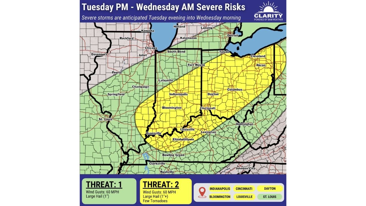
The latest outlook highlights a well-defined band of stronger storms capable of producing damaging wind gusts up to 60 mph, large hail exceeding one inch, and isolated tornadoes, particularly in areas within the higher-risk zone.
Severe Risk Zone Expands Across Key Midwest Cities
The most intense threat is now centered across a diagonal corridor stretching from southwestern Indiana through central Indiana into western and central Ohio.
Cities most directly in the higher-risk zone include:
- Indianapolis
- Bloomington
- Evansville
- Louisville
- Cincinnati
- Dayton
- Columbus
These areas fall under a Level 2 severe threat, where storms could become organized enough to produce rotating cells and brief tornadoes, along with damaging wind and hail.
Meanwhile, surrounding regions including St. Louis, northern Indiana, and parts of Michigan and Illinois remain under a Level 1 risk, where storms are still possible but expected to be less intense overall.
Timing Window Shows Overnight Storm Progression
The severe weather is expected to unfold in a clear time window:
- Tuesday Evening: Storms begin developing and organizing over Indiana
- Late Night: Strongest storms track into Ohio and Kentucky
- Early Wednesday Morning: System weakens while moving eastward
The overnight timing increases concern, especially as storms may arrive while many residents are asleep.
Main Threats Residents Should Prepare For
Across the higher-risk corridor, the following hazards are expected:
- Damaging Winds: Gusts up to 60 mph capable of downing trees and power lines
- Large Hail: Hailstones potentially exceeding 1 inch in diameter
- Tornado Risk: A few brief tornadoes cannot be ruled out, especially in central Indiana and western Ohio
Even outside the main risk zone, isolated strong storms may still produce gusty winds and small hail.
Why The Risk Shifted East
Recent atmospheric trends indicate a faster-moving cold front, which is pushing the severe weather zone farther east than earlier projections. This shift places more of Ohio and eastern Indiana into the primary impact area while slightly reducing intensity in western regions like Missouri.
What This Means For Residents Overnight
The combination of overnight timing and fast-moving storms creates a scenario where warnings may come with little lead time. Residents across Indiana, Ohio, and Kentucky should ensure they have:
- Weather alerts enabled on mobile devices
- Multiple ways to receive warnings overnight
- A plan to quickly move to a safe location if needed
Severe Storm Risk Breakdown Table
Below is a clear breakdown of the threat levels and impacts based on the latest data:
Final Outlook
As the system pushes east overnight, Indiana, Ohio, and Kentucky now sit in the core impact zone, with the greatest concern centered on wind damage, hail, and isolated tornado potential. The evolving track reinforces the need for preparedness, especially with storms expected to arrive during overnight hours when awareness is lower.
Residents across the region should remain alert as conditions develop Tuesday evening into Wednesday morning.