
Indiana, Ohio, Kentucky, Virginia, Maryland, and Washington DC Braced for Life-Threatening Cold as Wind Chills Plunge to −25°F
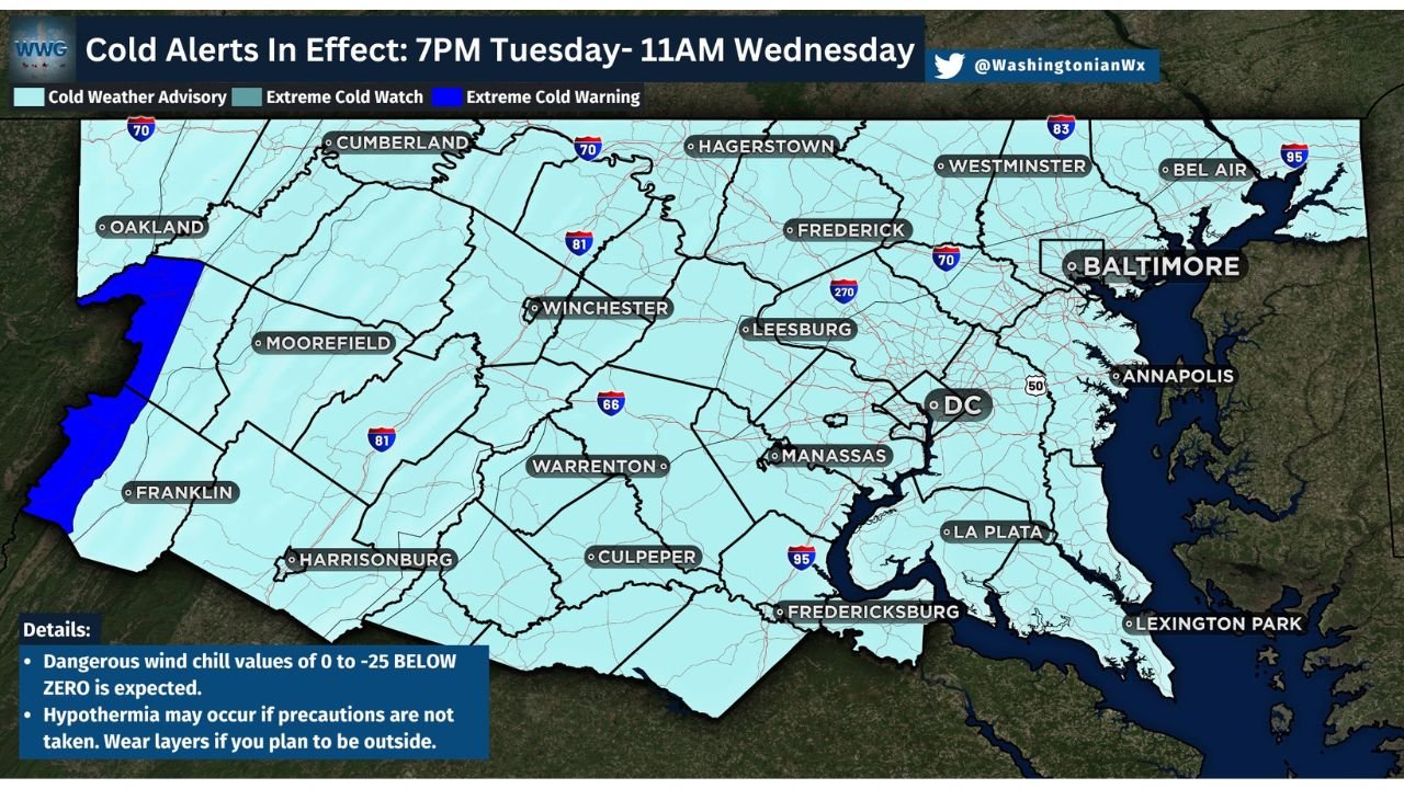
VIRGINIA — Another dangerous round of extreme cold and wind chill alerts is gripping a large portion of the Midwest and Mid-Atlantic, with life-threatening cold conditions expected from Tuesday evening through late Wednesday morning. National Weather Service offices across the region warn that wind chills as low as −25°F could lead to rapid frostbite and hypothermia, especially overnight and during early morning hours.
Extreme Cold Warnings and Advisories Now in Effect
According to the latest National Weather Service updates, Extreme Cold Warnings and Cold Weather Advisories are active across central and southern Indiana, large parts of Ohio and Kentucky, and much of Virginia, Maryland, and the Washington DC metro area.
- Extreme Cold Warning areas may see wind chills between −20°F and −25°F
- Cold Weather Advisory areas can expect wind chills from −15°F to near −20°F
- Cold alerts are valid from around 7–10 PM Tuesday through late Wednesday morning
Forecasters stress that even short exposure outdoors can become dangerous under these conditions.
Why This Cold Is Especially Dangerous
The combination of strong Arctic air and persistent winds is creating conditions where frostbite can occur in as little as 20–30 minutes, particularly on exposed skin such as fingers, ears, and face.
Health officials warn:
- Hypothermia can develop quickly, even if temperatures don’t look extreme on a thermometer
- Wind chill, not air temperature, is the main threat
- Elderly residents, children, outdoor workers, and those without reliable heating face the highest risk
Areas Facing the Greatest Impact
The most severe conditions are expected across:
- Central and southern Indiana
- Northern and central Kentucky
- Central and western Ohio
- Northern and central Virginia
- Maryland and the Washington DC metro
- Parts of West Virginia and the Mid-Atlantic interior
Urban areas are not exempt, as wind funneling between buildings can intensify exposure, especially overnight.
Safety Officials Urge Immediate Precautions
Emergency managers and weather officials strongly recommend the following actions:
- Dress in multiple layers, not a single heavy coat
- Cover all exposed skin, including face and hands
- Limit time outdoors, especially overnight and early morning
- Keep pets indoors as much as possible
- Check on elderly neighbors and family members
- Avoid using unsafe heating sources, including grills or open flames indoors
- Protect pipes by letting faucets drip and opening cabinet doors where plumbing is exposed
Officials also warn not to rub frostbitten skin and to seek medical attention immediately if numbness, discoloration, or confusion occurs.
When Conditions Will Improve
Temperatures are expected to slowly recover later Wednesday, but forecasters caution that cold ground and lingering wind chills may keep conditions hazardous into the afternoon in some areas.
Another surge of Arctic air cannot be ruled out later this week, and residents are urged to stay alert for additional updates.
Stay safe and stay informed. For continuous weather updates, safety alerts, and regional impact coverage, follow WaldronNews and share this information with anyone who may be vulnerable to extreme cold.