
Inverted Trough Could Sneak in Extra Snow for Long Island, Connecticut, Rhode Island and Massachusetts as Ocean-Effect Snow Lingers in New England
UNITED STATES — A narrow but important winter wildcard is on the table for the Northeast: an inverted trough that could quietly strengthen along a nearby frontal boundary, creating a thin stripe of heavier snow from Long Island and coastal New York into southern New England. Forecasters still expect the feature to be less intrusive overall, but the latest guidance warns that these setups can be unpredictable—and if the boundary “catches” the trough, a surprise couple of extra inches could show up in the most favored corridor.
At the same time, the pattern keeps ocean-effect snow (OES) in play, especially closer to the New England coastline, where cold air crossing relatively warmer Atlantic waters can keep snow showers going longer than expected.
What an inverted trough is, and why it can create surprise totals
An inverted trough is a lower-pressure “finger” that extends back from a coastal low or boundary and can act like a conveyor belt for lift and moisture. The key problem for forecasters is that:
- It can be narrow (meaning totals change fast over short distances)
- It can strengthen suddenly if the front/boundary enhances it
- It can create banding, where snowfall rates briefly increase enough to add “bonus” accumulation
In short: it’s often the reason two towns 15–25 miles apart can end up with noticeably different totals.
Current expectation: a less intrusive feature — but growth is possible
The message in the update is straightforward: the safer bet is a less intrusive inverted trough, meaning most places do not get hammered.
But the same update highlights the risk: the frontal boundary could entice its growth. If that happens, the upside scenario isn’t a blockbuster storm—it’s more like an impressive surprise, where the favored band picks up a couple of extra inches over what people were expecting.
That’s the kind of “looks manageable on paper, gets messy in real life” snow that can still create travel issues during the heaviest burst.
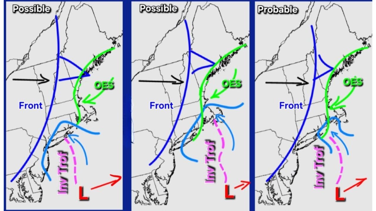
Three scenarios being watched: possible vs. probable outcomes
The diagrams show a few ways this can evolve, but the theme is consistent: a front is in place, the trough tries to develop along/near it, and the snow axis can shift.
Scenario outcomes being implied:
- Possible: the inverted trough forms but stays weaker or more offshore, limiting enhancement
- Possible: the trough becomes better organized and pulls heavier snow closer to the coast
- Probable: the trough signal appears more locked in, favoring a better-defined coastal snow stripe
The main takeaway isn’t the exact line placement—it’s that the feature exists, and its final position can still drift, changing who gets the extra inches.
Most likely “extra snow” corridor: Long Island to southern New England
Based on the pattern shown and the areas typically favored in these setups, the corridor most likely to see enhancement includes:
- Long Island, New York
- Coastal Connecticut
- Rhode Island
- Eastern and southeastern Massachusetts (including coastal zones)
If the inverted trough strengthens, the enhanced band can set up somewhere in this coastal arc—often not far inland, and sometimes right near the immediate shoreline.
Ocean-effect snow is also on the table
The update also notes OES (ocean-effect snow) “is there to be had as well.” That matters because even after the main organized snow shifts or fades, ocean-effect snow can:
- Keep light to occasionally moderate snow showers going in coastal zones
- Add additional minor accumulation in persistent bands
- Extend the duration of slick travel conditions beyond the “main” snow window
This is especially relevant for parts of coastal New England, where the cold-air flow over the Atlantic can keep snow showers firing.
What to watch tonight: signs the trough is strengthening
Because inverted troughs can ramp up quickly, the best real-time clue is what happens on radar and at the surface.
Signs the “extra inches” scenario is happening:
- Snow transitions from scattered flakes to a more organized band
- Visibility drops and snowfall rates briefly increase
- Snow becomes steadier along a narrow corridor while nearby areas stay lighter
- Reports of totals jumping faster than expected within a small zone
If you’re in Long Island, coastal Connecticut, Rhode Island, or eastern/southeastern Massachusetts, you’re in the region where this kind of band can matter most.
Bottom line
This is not being framed as a widespread major storm. Instead, it’s a banding and enhancement risk—where most areas do fine, but a smaller coastal stripe could end up with a couple extra inches if the inverted trough grows along the front. Add in ocean-effect snow potential, and some coastal communities may deal with longer-lasting nuisance snow than the broader forecast suggests.
If you’re in the Northeast coastal corridor, are you seeing steadier snow bands yet—or just light/flurries? Share what you’re seeing and keep following updates on WaldronNews.com.