
Iowa and Eastern Oklahoma Identified as Two Main Tornado Zones Friday as Forecast Models Suggest Bimodal Severe Weather Setup
UNITED STATES — Meteorologists are highlighting a potentially unusual two-zone tornado setup across the central United States on Friday, with the highest chances for rotating storms expected in parts of Iowa near a warm front and across eastern Oklahoma ahead of a dryline. Forecast guidance from ensemble weather models suggests these two regions may become the primary areas where supercell thunderstorms capable of producing tornadoes could develop.
The setup, sometimes referred to as a “bimodal tornado threat,” occurs when two separate atmospheric boundaries support storm development in different regions at the same time.
First Tornado Risk Zone Developing Along Iowa Warm Front
The northern severe weather corridor is expected to develop along a warm front stretching across parts of Iowa and nearby areas of the Midwest.
Forecast ensemble guidance indicates that storms forming along this boundary could organize into rotating thunderstorms, especially where warm and humid air collides with cooler air to the north.
Cities across Iowa that could be impacted include areas near:
- Des Moines
- Ames
- Cedar Rapids
- Davenport
Storms in this region may form during the late afternoon or evening hours, and if conditions align properly, some could produce tornadoes or damaging wind gusts.
Forecasters say warm fronts often create favorable environments for low-level rotation, which can increase tornado potential if storms become organized.
Second Tornado Corridor Possible Across Eastern Oklahoma
A second, potentially more active severe weather zone may develop farther south across eastern Oklahoma and parts of surrounding states, where storms are expected to form ahead of a dryline.
This region could include communities near:
- Tulsa
- Muskogee
- Fort Smith
- Fayetteville
Drylines are common storm triggers across the Plains, marking the boundary between dry desert air and warm, humid Gulf air.
When thunderstorms develop along this boundary, they can sometimes become discrete supercells capable of producing tornadoes, large hail, and damaging winds.
Kansas City Area May See Limited Storm Development
Interestingly, meteorologists note that areas near Kansas City may see less storm activity, despite being located between the two primary severe weather zones.
Forecast guidance suggests that weaker atmospheric forcing and cloud cover may limit instability in the Kansas City region, potentially reducing storm intensity there compared to areas farther north and south.
Because of this, the strongest severe storms may develop on either side of the Kansas City region rather than directly over it.
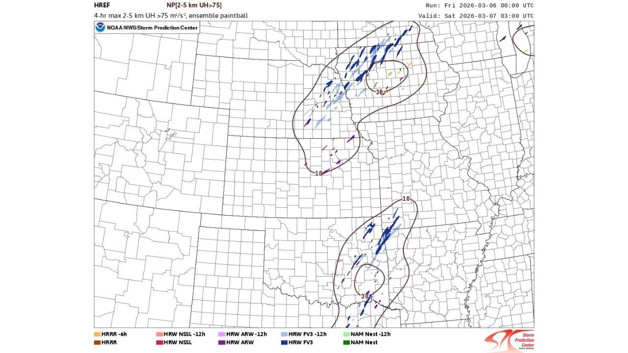
Ensemble Forecast Models Showing Consistent Signals
Weather analysts say the HREF ensemble model system, which combines multiple forecast simulations, has been consistently highlighting these two zones of stronger storm rotation.
The model output shows clusters of potential supercell tracks forming:
- Across Iowa along the warm front
- Across eastern Oklahoma ahead of the dryline
These model signals suggest that atmospheric conditions may support multiple rotating thunderstorms capable of producing severe weather hazards.
Severe Weather Threat Could Include Tornadoes, Hail and Strong Winds
If storms develop as expected, hazards across the affected regions could include:
- Tornadoes
- Large hail
- Damaging wind gusts
However, meteorologists emphasize that storm intensity will depend heavily on how instability develops throughout the day and whether storms remain isolated or merge into clusters.
Weather Conditions Still Evolving
Although forecast guidance is pointing toward these two main severe weather corridors, meteorologists stress that exact storm placement could still shift as new model data arrives.
Even small changes in atmospheric boundaries such as the warm front position or dryline movement could significantly influence where the strongest storms form.
Residents across the Plains and Midwest are encouraged to stay alert to updated forecasts as the severe weather setup evolves.
Stay with WaldronNews for continuing updates as meteorologists track this developing two-zone tornado threat across the central United States.