
Iowa Tornado Report Released Near Iowa City as Rare Rope Funnel Event Draws Attention Across Johnson and Cedar Counties
IOWA — A newly confirmed tornado report is drawing attention across eastern Iowa after a brief but clearly defined tornado touched down southeast of Iowa City, leaving behind a narrow path of damage across parts of Johnson and Cedar Counties.
Officials have now confirmed the tornado as an EF0, with estimated peak winds reaching 80 mph, marking a relatively weaker event on the Enhanced Fujita scale — but one that still caused noticeable localized damage.
Tornado Timeline and Location Details
The tornado occurred on Friday, April 2, and remained on the ground for approximately:
- 3 minutes total
- Between 4:36 p.m. and 4:39 p.m.
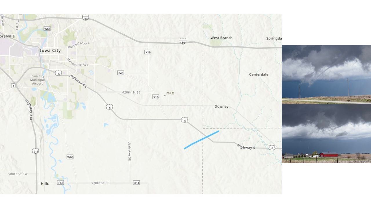
The touchdown area was located south of Downey, Iowa, with the tornado tracking along rural sections near:
- 480th Street SE
- South of Highway 6 SE
It then moved northeast, briefly crossing the highway before dissipating near Baker Avenue.
Path Length and Structure
Survey data shows the tornado traveled:
- 2.19 miles in total length
- Along the Johnson–Cedar County line
What makes this event particularly notable is its structure:
- Described as a pencil-thin, rope-like funnel
- Maximum width estimated at around 150 feet
- Much narrower for most of its lifespan
This type of tornado is often harder to detect visually and can appear deceptively weak, despite still producing damage.
Damage Reports Confirm Ground Impact
Despite its short duration and narrow width, the tornado still caused multiple forms of localized damage, including:
- A corn crib being lifted and displaced
- Snapped trees along its path
- A bent auger, indicating strong rotational force
- Partial roof damage to a farm outbuilding
These impacts are consistent with an EF0 classification but highlight how even weaker tornadoes can disrupt rural areas.
Visual Confirmation and Storm Structure
The tornado was fully condensed at times, allowing for clear visual documentation. Images from the area show:
The rope-like appearance made this tornado especially unique, with a thin, twisting funnel extending from low storm clouds to the ground, a classic visual seen in weakening or short-lived tornadoes.
No Injuries Reported
One of the most important outcomes from this event is that:
- No injuries or fatalities were reported
This is largely due to the tornado’s:
- Short lifespan
- Limited path length
- Rural location
Why This Tornado Still Matters
Even though classified as an EF0, this event serves as a reminder that:
- All tornadoes pose a risk, regardless of strength
- Brief events can still cause structural and agricultural damage
- Rural areas are often more exposed due to open terrain
Additionally, rope tornadoes like this one can be difficult to spot, increasing the importance of staying weather-aware during severe conditions.
A Reminder as Severe Season Continues
This confirmed tornado comes as early April continues to show increasing severe weather activity across parts of the Midwest.
Events like this highlight that:
- Tornado season is active and evolving
- Even marginal setups can produce brief tornadoes
- Monitoring alerts and radar remains critical
Residents across Iowa and surrounding states are encouraged to stay alert as spring severe weather patterns continue to develop.
Stay with WaldronNews.com for continued updates on tornado activity, storm reports, and developing weather threats across the United States.