
Isolated Hailstorms Target Midland–Odessa, Fort Stockton and Alpine Friday Night as West Texas Faces Marginal Severe Risk With Quarter to Half-Dollar Size Hail Possible
TEXAS — Parts of West Texas and the Permian Basin could see isolated severe thunderstorms Friday evening, February 13, with hail emerging as the primary concern from Midland–Odessa south and west toward Fort Stockton and Alpine.
Forecast guidance indicates a Level 1 out of 5 Marginal Risk for severe weather across portions of the region, including:
- Midland–Odessa
- Fort Stockton
- Alpine
- Fort Davis
- Monahans
- Big Spring
- Andrews
- Gardendale
- Crane
- Rankin
- Sanderson
While widespread severe weather is not expected, a few storms could become strong enough to produce hail up to quarter size, with isolated reports potentially reaching half-dollar size in the most intense cells.
Storms Developing Along Frontal Boundary
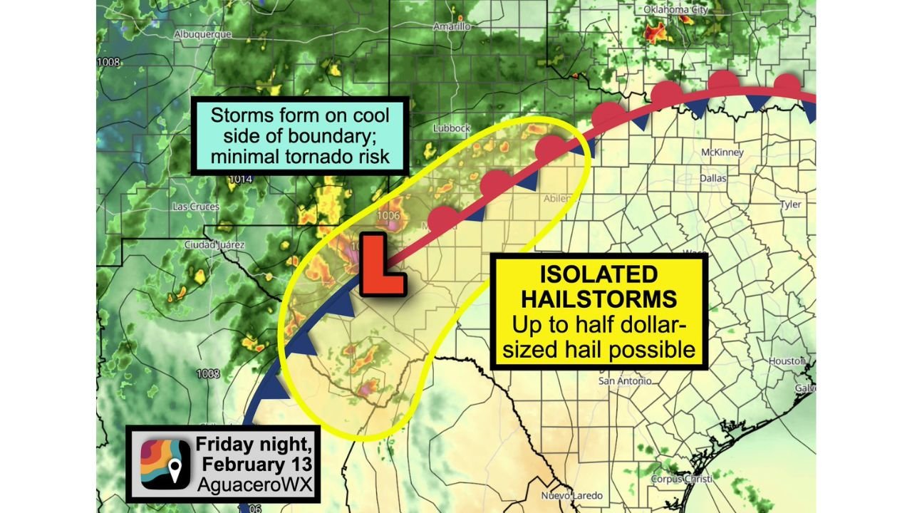
A developing low-pressure system Friday evening will interact with a frontal boundary stretching across West Texas. As this low organizes, scattered showers and thunderstorms are expected to form.
However, most storms are projected to develop behind the boundary on the cooler side, meaning they will be classified as “elevated” storms.
Elevated storms are rooted in milder air above a shallow cool layer near the surface. This setup significantly lowers tornado potential but still supports strong updrafts capable of producing hail.
Minimal Tornado Risk, Hail Main Hazard
Because storm development will occur primarily north and west of the surface boundary, forecasters are not anticipating a meaningful tornado threat. Instead, the main impacts are expected to include:
- Isolated hailstorms
- Brief heavy rainfall
- Gusty winds in stronger cells
The strongest thunderstorms could briefly intensify enough to produce hail larger than quarters, particularly in areas between Midland–Odessa and Fort Stockton.
Timing and Location Focus
The most favorable window for stronger storms appears to be Friday evening into the overnight hours.
Communities most likely to experience stronger activity include:
- The Permian Basin
- Areas south of Lubbock
- West of Abilene
- Near the I-20 corridor between Midland and Big Spring
- Portions of southwest Texas near Alpine and Fort Davis
Storm coverage is expected to remain scattered rather than widespread.
What Residents Should Watch For
Residents across West Texas should remain alert Friday evening for:
- Hail that could damage vehicles or outdoor property
- Brief heavy downpours reducing visibility
- Lightning associated with thunderstorms
Because storms will be elevated, the primary concern remains hail rather than tornadoes or widespread damaging winds.
Waldronnews.com will continue monitoring storm development across the Permian Basin and surrounding West Texas communities as Friday evening approaches.