
Jet Stream Energy Triggers Mountain Snow Showers Across Colorado and Wyoming, With Cheyenne, Fort Collins and Aspen Seeing Radar Returns
COLORADO & WYOMING — A burst of jet stream energy sweeping across the central Rockies is lighting up radar screens Tuesday, sparking scattered snow showers in the mountains and along the northern Front Range — though much of it is struggling to reach the ground.
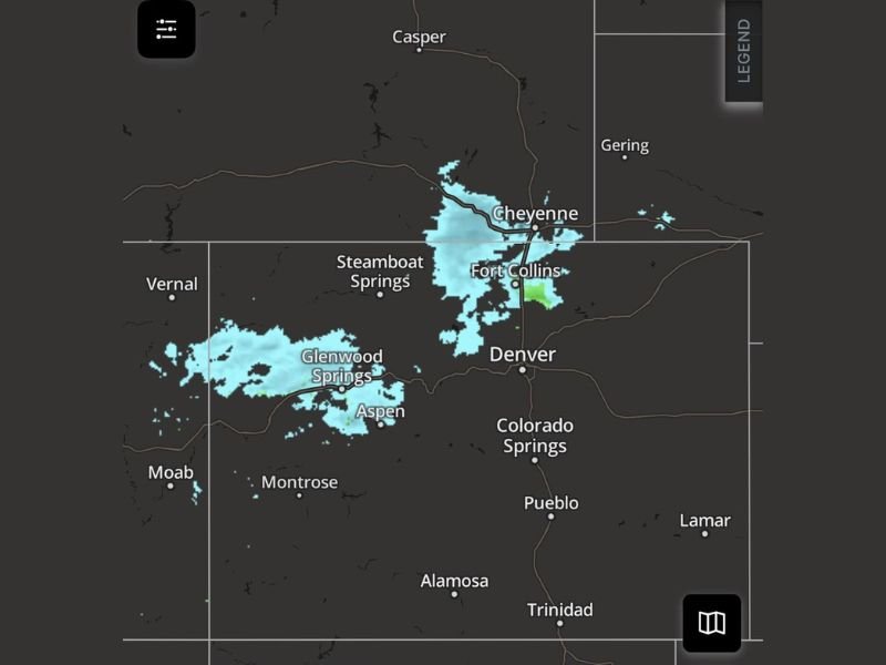
Current radar imagery shows bands of light precipitation stretching from Glenwood Springs and Aspen eastward toward Fort Collins and Cheyenne, with additional pockets near Steamboat Springs. However, forecasters note that a significant portion of these echoes may be evaporating before reaching the surface.
Radar Returns Focused on the Mountains and Northern Front Range
The most concentrated activity is centered across:
- Western Colorado mountains near Glenwood Springs and Aspen
- Northern Colorado near Fort Collins
- Southern Wyoming around Cheyenne
- Portions of the northern Front Range corridor
These returns are associated with strong upper-level jet stream dynamics creating lift over the higher terrain.
Much of the Precipitation Not Reaching the Ground
Despite what radar indicates, surface conditions may not reflect steady snowfall everywhere. Dry low-level air is causing some precipitation to evaporate before it reaches ground level — a common occurrence in early-season or marginal setups.
Still, brief bursts of:
- Light snow
- Snow showers
- Occasional mixed precipitation or “snur” (snow + rain)
could pop up intermittently across:
- The I-25 corridor
- Foothill communities west of Denver
- Portions of the eastern plains
Preview of a More Active Pattern Midweek
Meteorologists suggest this activity may be a preview of more organized mountain precipitation expected Wednesday and Thursday.
The jet stream remains active over the region, and continued upper-level energy could enhance:
- Mountain snow showers
- Intermittent foothill rain/snow mix
- Light accumulations in higher elevations
Communities near Steamboat Springs, Aspen, Glenwood Springs, and the northern Front Range may see off-and-on precipitation through midweek.
Impact on Major Cities
For larger metro areas including:
- Denver
- Colorado Springs
- Pueblo
Most precipitation should remain light and spotty, though occasional passing showers cannot be ruled out, especially north toward Fort Collins and Cheyenne. Travel impacts at lower elevations are expected to remain minimal at this time, but mountain passes could see slick conditions during heavier bursts.
What to Watch
Residents should monitor:
- Changing radar trends
- Brief visibility reductions in mountain areas
- Possible minor travel impacts along I-25 north of Denver
With the jet stream remaining active, this unsettled pattern bears watching through the latter half of the week. Stay with WaldronNews.com for continuing coverage of Rocky Mountain weather developments and detailed regional forecasts as the midweek system evolves.