
Kankakee, Illinois Supercell Intensifies After Warm Front Merger Near Buckingham, Producing Rapid Surface-Based Rotation
KANKAKEE COUNTY, ILLINOIS — A detailed radar analysis of the powerful Kankakee supercell reveals that a critical merger event along a warm front played a pivotal role in the storm’s rapid intensification and transition to a surface-based tornado-producing system.
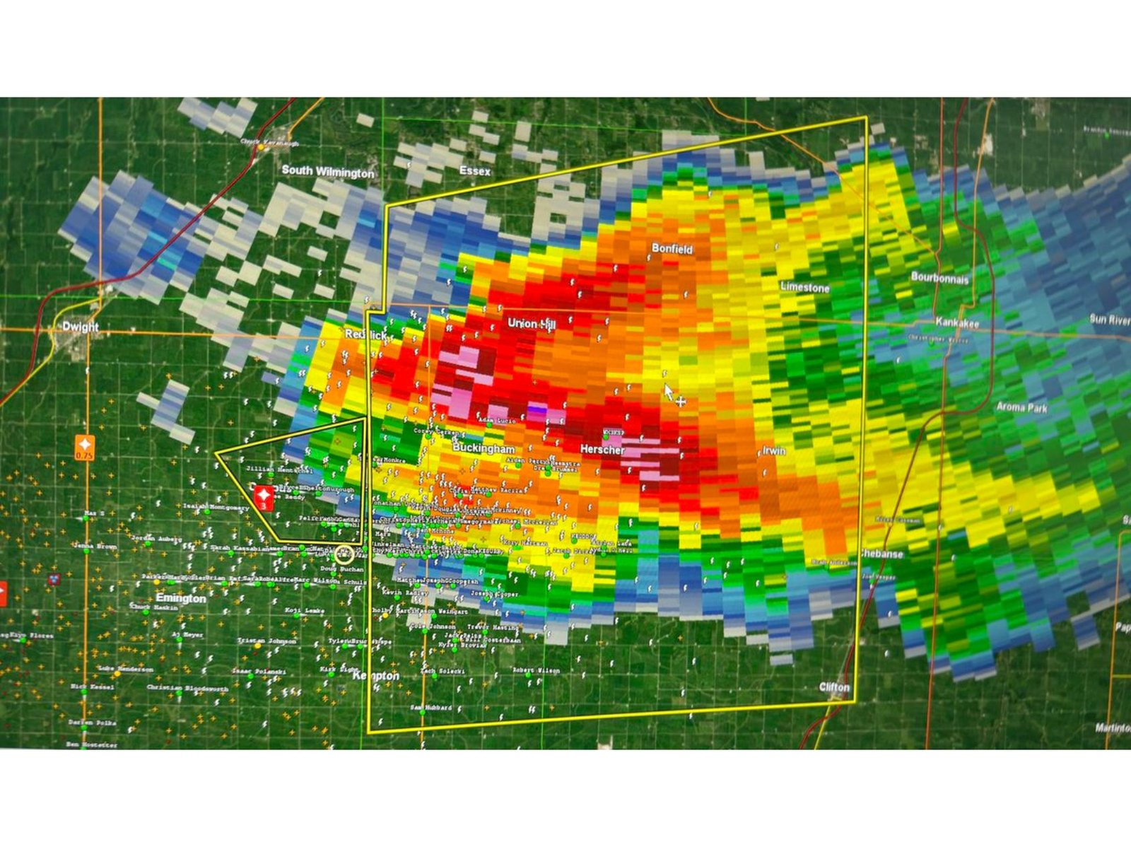
Meteorological observations indicate that as the storm approached the warm front near Buckingham, Illinois, a large updraft merger developed within the inflow region of the supercell. This interaction significantly enhanced the storm’s structure and allowed it to latch onto the boundary, strengthening rotation and accelerating its evolution.
Warm Front Interaction Triggered Rapid Intensification
The supercell’s interaction with the warm front appears to have been the turning point in its lifecycle. As the storm crossed the boundary, it encountered a more favorable environment with increased low-level moisture and wind shear.
This interaction enabled the storm to become fully surface-based, a critical step for tornado development. Radar imagery captured a strengthening inflow structure and an expanding area of intense reflectivity as the merger progressed across Kankakee County.
Updraft Merger and Left Split Occurred Simultaneously
Around the same time the updraft merger was underway, a left-moving storm split developed and moved away from the primary supercell. Additionally, several smaller storm cells — described as “nudgers” — passed through the region during the merger process.
The near-simultaneous occurrence of these events likely contributed to the supercell’s abrupt rightward turn and intensification. Meteorologists believe this combination of storm interactions allowed the Kankakee supercell to maintain strong inflow and sustain its rotation.
Radar Observations Highlight Key Features
High-resolution radar data, particularly from the KLOT radar site, provided crucial insight into the storm’s structure. While the merger was not immediately evident on lower radar tilts, it became clearly visible at higher elevations.
Key radar features included:
- A massive ground-scraping inflow tail observed near Buckingham
- Intensifying reflectivity cores exceeding severe thresholds
- Strengthening rotational signatures within the storm’s updraft
- A pronounced hook echo as the supercell matured
Observers reported that the inflow tail became highly visible roughly 10 to 15 minutes before the development of a wall cloud, signaling the storm’s transition into a tornadic phase.
Why the Merger Was Initially Overlooked
Despite its significance, the updraft merger was not widely recognized in real time. Analysts note that the feature was subtle on lower radar tilts and more apparent only in higher-level scans.
This delayed recognition highlights the complexity of supercell interactions and underscores the importance of multi-level radar analysis when monitoring severe weather events.
Bottom Line
The Kankakee supercell’s rapid intensification was strongly influenced by an updraft merger along a warm front near Buckingham, Illinois, enabling the storm to become surface-based and produce significant rotation. The combination of boundary interaction, storm splitting, and enhanced inflow created an environment highly favorable for severe weather development.
Stay with WaldronNews.com for continued coverage of severe weather analysis, storm structure insights, and regional meteorological updates across Illinois and the Midwest.