
Kansas City, St. Joseph, Kirksville and Northern Missouri Brace for 35–40 MPH Wind Gusts Sunday Before Cooler Air and Late-Week Rain Return
KANSAS CITY, MO — Gusty northerly winds will continue sweeping across Kansas City and northern Missouri through much of Sunday evening, with peak gusts reaching between 35 and 40 miles per hour before gradually easing overnight.
According to the latest forecast update issued Sunday afternoon, communities across northern and western Missouri will remain under breezy conditions through late evening as cooler air settles in behind a passing cold front.
Wind Gusts Peaking Late Sunday Afternoon
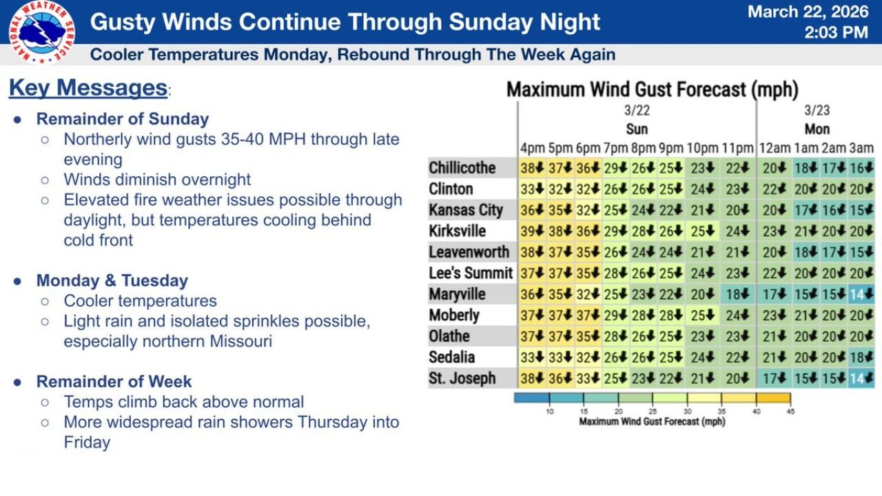
Forecast maximum wind gusts Sunday evening include:
- Kirksville: Up to 39 mph around 4 PM
- Chillicothe: Near 38 mph
- St. Joseph: Around 38 mph
- Maryville: 36 mph
- Kansas City: Near 36 mph
- Lee’s Summit: Around 37 mph
- Leavenworth: 38 mph
- Moberly: 37 mph
- Olathe: 37 mph
- Sedalia: 33 mph
- Clinton: 33 mph
Winds are expected to steadily diminish later tonight, dropping into the teens and lower 20s after midnight.
Elevated Fire Weather Concerns
While temperatures are cooling behind the cold front, the combination of dry air and strong winds through daylight hours may create elevated fire weather conditions, particularly in open or rural areas. Residents are urged to avoid outdoor burning until winds subside.
Cooler Temperatures Monday and Tuesday
The new workweek begins on a cooler note across Missouri and eastern Kansas. Temperatures Monday and Tuesday will remain below recent highs, providing a temporary break from the gusty and warmer pattern.
In addition to cooler air, light rain and isolated sprinkles are possible Monday and Tuesday, especially across northern Missouri, including areas near:
- Kirksville
- Maryville
- Chillicothe
- Moberly
- St. Joseph
Rainfall amounts early in the week are expected to be light and scattered.
Temperatures Rebound Midweek
By mid to late week, temperatures are forecast to climb back above normal levels. The brief cool-down will give way to milder conditions heading into Wednesday.
More Widespread Rain Late Week
A more organized system is expected to bring widespread rain showers Thursday into Friday, potentially affecting much of northern and central Missouri, including the Kansas City metro area.
Forecasters note that late-week rainfall will be more widespread compared to the isolated sprinkles expected early in the week.
What to Expect
- Gusty winds continue through Sunday evening
- Winds weaken overnight
- Cooler temperatures Monday and Tuesday
- Light sprinkles possible in northern Missouri
- Warmer temperatures return midweek
- Widespread rain likely Thursday into Friday
Residents across Kansas City and northern Missouri should secure loose outdoor items through Sunday evening and stay weather-aware as the week’s changing conditions unfold.
Stay with WaldronNews.com for continued updates on wind advisories, temperature trends, and late-week rainfall impacts across Missouri and the central Plains.