
Kansas Evening Storm Alert Issued As Rapid Line Of Severe Thunderstorms Targets Eastern Kansas With Damaging Winds And Hail Threat
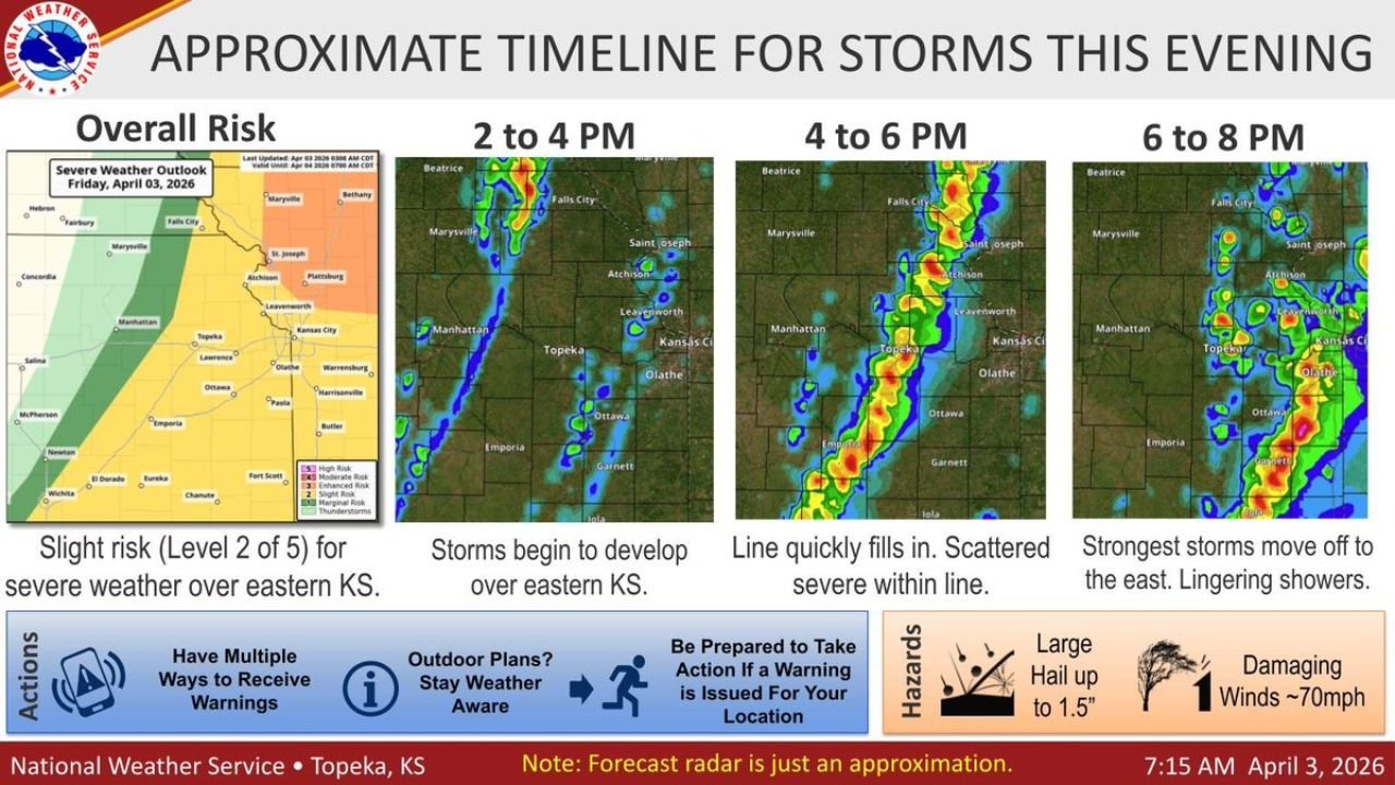
KANSAS — A fast-developing line of storms is expected to quickly intensify across eastern Kansas this afternoon, bringing a targeted window of severe weather between 2 PM and 8 PM, with the greatest impacts expected during the late afternoon and early evening hours.
This setup is tied to a cold front pushing through the region, creating conditions favorable for scattered severe storms embedded within a larger line.
Storm Development Begins Early Afternoon Across Eastern Kansas
Forecast timing shows a clear progression:
- 2 PM – 4 PM: Initial storms begin developing across eastern Kansas, including areas near Topeka, Manhattan, and Emporia
- 4 PM – 6 PM: Storms rapidly organize into a more continuous line, increasing the risk of severe weather
- 6 PM – 8 PM: Strongest storms shift east toward the Kansas City metro, gradually weakening later in the evening
This means communities will see rapid changes in weather conditions within just a few hours.
Damaging Winds And Large Hail Are The Primary Threats
While not every location will experience severe weather, the storms that do strengthen could produce:
- Damaging wind gusts up to 70 mph
- Large hail up to 1.5 inches in diameter
- Brief intense downpours and frequent lightning
The severe threat will be scattered in nature, meaning some areas could see strong impacts while nearby locations experience much less.
Kansas City Metro In Evening Impact Zone
As storms track east, the Kansas City metro area will likely be impacted during the early to mid-evening hours, especially between:
- 5 PM and 7 PM
Cities at risk include:
- Kansas City (Kansas and Missouri)
- Olathe, Overland Park, Lee’s Summit
- Lawrence and surrounding eastern Kansas communities
Storms Expected To Move Out By Mid-Evening
By later in the evening:
- The main line of storms will push east of the region
- Lingering showers may continue briefly, but the severe threat will decrease significantly
Not Everyone Will See Severe Weather — But Be Ready
This is not expected to be a widespread, uniform severe event. However:
- Any storm within the line can quickly become severe
- Conditions may change with little warning as the line fills in
Residents should remain weather-aware throughout the afternoon and evening.
Safety Reminders As Storms Approach
With storms developing quickly, preparation is critical:
- Enable weather alerts on your phone
- Monitor radar and updates closely
- Be ready to move indoors if warnings are issued
Fast-Moving Line Will Bring Short But Intense Impacts
The biggest concern with this system is its speed and sudden intensification, meaning impacts may be brief but potentially strong.
Even short-lived storms could produce localized damage from wind or hail, especially during the peak 4 PM to 7 PM window.
Stay with WaldronNews.com for live updates, storm tracking, and real-time alerts as this fast-moving severe weather line develops across Kansas this afternoon and moves toward Missouri this evening.