
Kansas, Missouri, Oklahoma, Illinois, Indiana, and Arkansas Face Record-Breaking Christmas Warmth as Temperatures Surge 30–40°F Above Normal
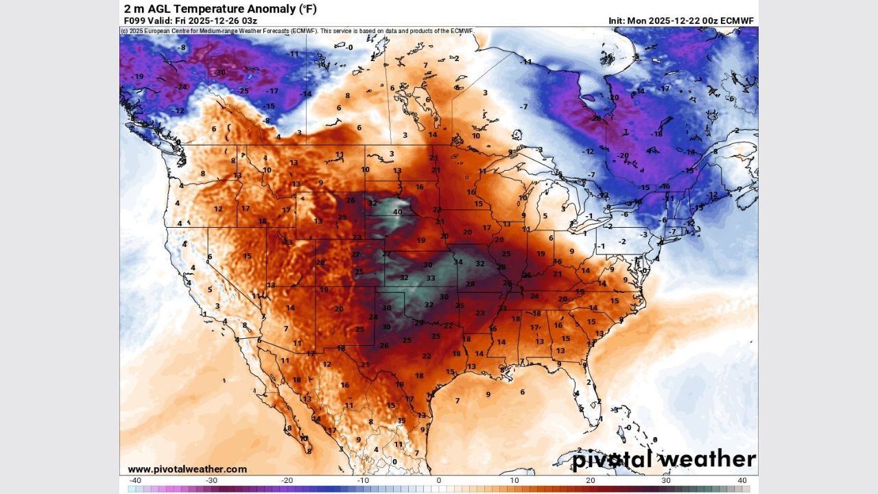
MIDWEST & CENTRAL PLAINS — An extraordinary and potentially record-shattering Christmas warm spell is taking shape across Kansas, Missouri, Oklahoma, Illinois, Indiana, and Arkansas, where forecast data shows temperatures running 30 to nearly 40 degrees above normal, making this one of the warmest Christmas periods ever recorded for the region.
Weather model anomaly maps highlight a concentrated core of extreme warmth centered over the Central Plains and Midwest, with the strongest departures from normal stretching from Oklahoma and Kansas northeastward into Missouri, Illinois, and Indiana. In these areas, temperatures expected for December 25–26 resemble early spring rather than mid-winter.
Most Impacted Areas According to Forecast Data
The highest temperature anomalies are forecast across:
- Kansas — anomalies approaching +35 to +40°F
- Oklahoma — widespread +30°F or greater
- Missouri — sustained +25 to +35°F
- Illinois & Indiana — large population centers 25–30°F above normal
- Arkansas — prolonged spring-like warmth
These states sit directly beneath the strongest upper-level ridge shown on forecast models, allowing warm air to surge northward without resistance from Arctic systems.
What Temperatures Will Feel Like
In the most impacted zones:
- Afternoon highs will reach the 60s and 70s
- Some locations in Oklahoma and southern Kansas may approach the low 80s
- Overnight lows may stay in the 50s, levels more typical of April
Cities such as Kansas City (MO), St. Louis (MO), Wichita (KS), Oklahoma City (OK), Indianapolis (IN), and Little Rock (AR) are all within the core warm sector and could challenge or exceed long-standing Christmas temperature records.
Why This Event Is Historically Significant
Late-December warm spells do occur, but the intensity and geographic concentration of this event is what makes it unusual. Temperature anomaly maps show deep, persistent warmth directly over the central United States, rather than a brief or coastal event.
Meteorologists note that anomalies exceeding +30°F during Christmas week are rare and often associated with record-breaking outcomes, especially when sustained over multiple days.
Potential Impacts Beyond Comfort
The warmth may bring several secondary effects:
- Accelerated snowmelt in northern portions of the Midwest
- Agricultural concerns, including early plant budding
- Increased travel confusion, with winter weather gear unnecessary in areas that typically need it
- Energy demand shifts, as heating needs drop sharply
Meanwhile, much colder air remains locked well north of the region, emphasizing the dramatic temperature contrast shown in the data.
Outlook Going Forward
Forecast confidence remains high that this warm pattern will dominate Christmas Day and the days immediately surrounding it. While colder weather could return later, the holiday period itself is expected to remain exceptionally warm across the Midwest and Central Plains.
Residents across the affected states are encouraged to stay informed, especially as record temperatures, travel impacts, and longer-term pattern changes continue to develop.
WaldronNews.com will continue monitoring this unusual Christmas weather event and provide updates as conditions evolve.