
Kansas, Oklahoma and Texas Brace for Expanding Heat Dome as Cooler Air Pushes Into California, Washington and Montana During Early April Pattern Shift
UNITED STATES — A major pattern transition is expected during the Week 2 timeframe, with forecast data showing the core of above-normal warmth shifting eastward while cooler air spreads into the western United States.
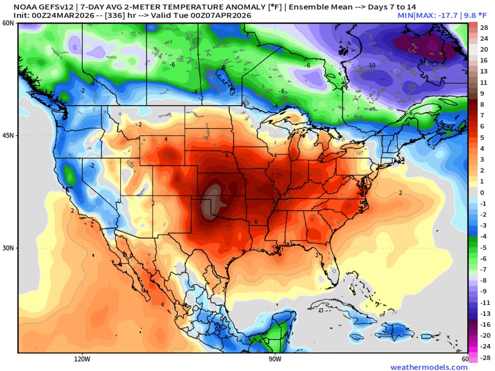
The latest 7-day average temperature anomaly outlook for early April highlights a broad area of well-above-normal temperatures centered over the central and south-central U.S., while much of the West trends cooler than average.
Central U.S. Turns Much Warmer Than Normal
The most intense warm anomalies are projected across:
- Kansas
- Oklahoma
- Texas
- Nebraska
- Missouri
- Arkansas
Forecast averages show temperatures running 6 to locally 10+ degrees above normal in parts of the central Plains.
The core of the heat signal appears strongest from western Oklahoma through central Kansas and into portions of north Texas, where deep red shading indicates the most significant departures from seasonal averages.
Warmth is also expected to expand east into:
- Illinois
- Indiana
- Iowa
- Tennessee
- Kentucky
- Mississippi
- Alabama
Much of the Midwest and lower Mississippi Valley could see sustained above-normal readings during this period.
Southern States Stay Warm
Above-average temperatures are also projected across:
- Louisiana
- Georgia
- South Carolina
- North Carolina
- Virginia
While the Southeast may not see the same intensity as the central Plains, the region is still expected to remain warmer than normal heading into early April.
Cooler Air Fills the Western U.S.
At the same time, cooler-than-average air is forecast to settle across much of the West, including:
- California
- Oregon
- Washington
- Idaho
- Montana
- Wyoming
- Nevada
Temperature anomalies of 2 to 6 degrees below normal are projected in many of these areas, particularly across the Pacific Northwest and northern Rockies.
This shift signals the breakdown of the earlier western warmth and the arrival of a more progressive pattern.
Northern Tier Turns Colder
Even more significant cold anomalies are indicated across parts of:
- North Dakota
- Minnesota
- Southern Canada
Some areas near the U.S.-Canada border could trend well below average during this timeframe.
What This Means for Storm Chances
As cooler air presses into the West and warmth expands eastward, the setup favors a more active weather pattern across the central and south-central United States.
Clashing air masses often increase opportunities for stronger storm systems, and the evolving pattern could support:
- Increased thunderstorm development
- Higher severe weather potential
- Sharper temperature contrasts across the Plains and Midwest
While exact storm details will become clearer closer to the timeframe, the overall setup suggests a more dynamic early April period compared to recent quieter stretches.
The Bottom Line
The upcoming pattern shift places the heat dome squarely over Kansas, Oklahoma and Texas, with warmth spreading east across much of the Midwest and Southeast. Meanwhile, California, Washington and Montana turn cooler as Pacific air moves inland.
This eastward migration of warmth and western cooling sets the stage for a potentially more active central U.S. weather pattern heading into early April.
Stay with WaldronNews.com for continued updates on this evolving national forecast pattern.