
Kansas Texas Oklahoma Missouri Severe Weather Alert Expands as 5 Day Storm Threat Targets Plains Into Midwest
UNITED STATES — A prolonged stretch of severe weather is now officially outlined across multiple states, with storm risks expected on five out of the next six days, signaling a clear shift into a much more active pattern across the central United States.
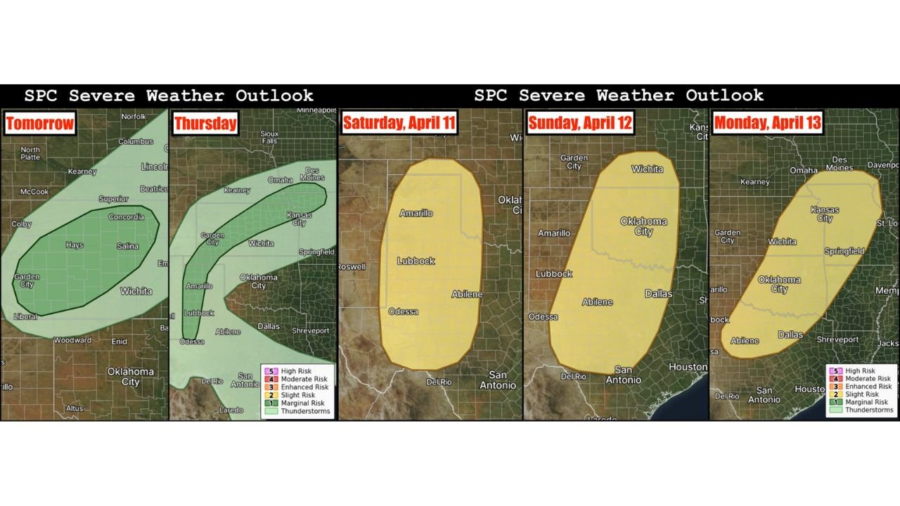
Forecast data highlights a multi-day sequence of storms developing from Kansas and Texas into Oklahoma and the Midwest, with increasing intensity heading into the weekend and early next week.
Wednesday Begins With Isolated Storm Risk in Kansas
The first phase of this pattern begins Wednesday, focusing on:
- Kansas
This day carries a low-end (Level 1/5) risk, but storms could still produce:
- Isolated large hail
- Damaging wind gusts
Storms are expected to form along a frontal boundary, meaning even limited activity could still bring localized impacts.
Thursday Expands Threat Into Kansas and West Texas
By Thursday, the setup becomes more dynamic, with risk areas expanding across:
- Kansas
- West Texas
This day is being described as a “sneaky” severe weather setup, where:
- A few well-structured supercells could develop
- Storms may later transition into clusters
Threats include:
- Large hail
- Damaging winds
- Isolated tornado potential cannot be ruled out
Saturday Targets West Texas With Stronger Setup
The weekend marks a clear escalation in storm potential, beginning Saturday across:
- West Texas
- Eastern New Mexico border regions
This setup introduces:
- A 15% severe risk zone (Slight Risk equivalent)
- Development along a dryline
- Increasing atmospheric energy
Storm modes may include:
- Supercells
- Mixed storm clusters
Primary threats:
- Large hail
- Damaging winds
Sunday Expands Severe Risk From Texas Into Kansas
Sunday is shaping up to be a more widespread and potentially more dangerous day, with the risk zone stretching from:
- Texas
- Through Oklahoma
- Into southern Kansas
This setup supports:
- Supercell development
- All hazards possible, including tornadoes
Cities in this corridor include:
- Dallas
- Oklahoma City
- Wichita
This marks one of the most important days to monitor closely in this multi-day pattern.
Monday Pushes Storm Threat Into Midwest and Central U.S.
By Monday, the storm system shifts northeast, impacting:
- Kansas
- Missouri
- Parts of the Midwest
This indicates a continuation of the storm track, with severe weather potential extending beyond the Plains.
The risk remains at a 15% severe level, suggesting continued threats of:
- Damaging winds
- Large hail
- Possible tornado activity
Pattern Signals Start of Active Severe Season
This extended forecast confirms that:
- The U.S. is entering a high-frequency severe weather period
- Multiple storm systems will move through in quick succession
- The Plains-to-Midwest corridor will remain a key focus zone
The presence of five risk days within six days highlights how sustained and organized this pattern is becoming.
More Risk Areas Likely Beyond Monday
Forecast guidance also indicates that:
- Additional severe weather days may be added
- The active pattern could continue deeper into April
- Confidence will increase as models refine timing and intensity
What Residents Should Do Now
With repeated storm chances expected, residents across affected states should:
- Monitor daily forecast updates
- Prepare for multiple rounds of storms
- Ensure warning alerts are active
- Review safety plans ahead of the weekend
A Multi-Day Severe Weather Stretch Is Now Underway
This is not a single storm event — it is the beginning of a prolonged severe weather stretch impacting millions across the central U.S.
From Kansas and Texas to Oklahoma and the Midwest, conditions are aligning for repeated storm development over several days, making this a critical period to stay weather-aware.
Stay with WaldronNews.com for continuous updates as this multi-day severe weather pattern unfolds.