
Kentucky and Illinois Under Tornado Warning as Dangerous Rotating Storms Race Along the Ohio River
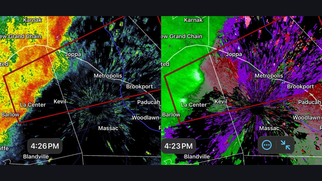
KENTUCKY AND ILLINOIS — A Tornado Warning was issued Tuesday afternoon along the Ohio River in western Kentucky as a strong cold front swept across the region, triggering a dangerous line of storms with confirmed rotation. Radar data shows two separate circulations embedded within the storm line, raising concerns for possible tornado development as the system moves northeast toward southern Illinois, including the Metropolis area.
The warning was issued at approximately 3:28 PM CST (4:28 PM EST) as meteorologists detected intensifying rotation within the storms.
Two Rotating Storms Detected Near the Kentucky–Illinois Border
High-resolution radar imagery indicates two distinct areas of rotation within the storm line stretching across western Kentucky, near communities along and just south of the Ohio River. These circulations were observed tracking northeast, increasing the risk for tornado formation as they approach Illinois.
“Two circulations are noted in the line of storms, and two tornadoes are possible,” forecasters warned.
The storms were moving quickly, giving residents limited time to respond if warnings are upgraded or extended.
Metropolis, Illinois in the Potential Path
Storm motion suggests the strongest rotation could reach Metropolis, Illinois, within 20 to 30 minutes of the initial warning issuance. Radar velocity data shows tightening wind fields as the storms cross the river, a setup that can rapidly produce tornadoes with little advance notice.
“Rotation areas are tracking northeast toward southern Illinois,” meteorologists stated.
Residents in Metropolis, Brookport, and surrounding Massac County areas were urged to remain alert and ready to take shelter immediately.
Cold Front Driving Severe Weather Threat
This tornado threat is being fueled by a powerful cold front sliding across the central United States, interacting with warm, unstable air ahead of it. The result is a fast-moving squall line capable of producing damaging winds, brief tornadoes, and heavy rain.
The radar imagery shows classic signatures of embedded mesovortices, which are especially dangerous because they can spin up tornadoes quickly within a line of storms.
What Residents Should Do Immediately
Emergency officials urge those in the warned area to take this situation seriously:
- Move to a basement or interior room on the lowest floor
- Stay away from windows
- Monitor local alerts and NOAA Weather Radio
- Be prepared for rapid changes in storm intensity
“If you are in the warned area, take cover now,” officials emphasized.
Ongoing Monitoring and Next Updates
Storms are expected to continue moving northeast through the region as the cold front advances. Additional warnings may be issued as rotation evolves or new circulations develop farther east.
WaldronNews.com will continue to closely monitor this active tornado situation in western Kentucky and southern Illinois and provide updates as new information becomes available.