
Kentucky, Tennessee and Indiana Face Midday Storm Line Saturday as Louisville, Bowling Green and Clarksville Track Wind and Rain Threat
KENTUCKY — A line of storms is expected to move across parts of Kentucky, Tennessee and southern Indiana on Saturday, bringing a period of gusty winds and steady rainfall around the midday hours. While the overall severe weather threat appears relatively low, forecasters say residents should still prepare for brief bursts of stronger storms as the system moves through.
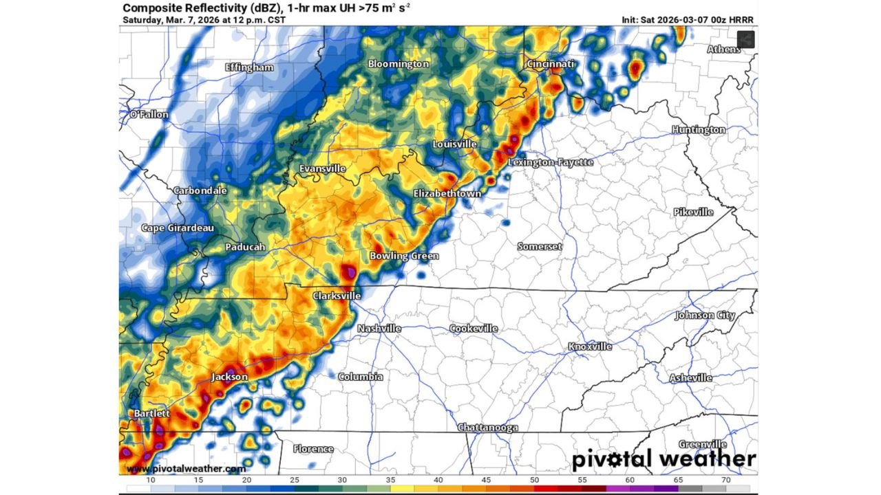
Forecast guidance from the 00z HRRR model shows a band of showers and thunderstorms organizing west of the Mississippi River early Saturday before pushing eastward into the Ohio Valley by midday.
Storm Line Expected to Move Toward Kentucky and Tennessee Around Midday
According to the latest high-resolution forecast model, the storm line could begin entering parts of western Kentucky and northern Tennessee between 12 p.m. and 1 p.m. Central Time, gradually advancing east through the afternoon.
Cities along and near the projected path of the storms include:
- Paducah, Kentucky
- Evansville, Indiana
- Bowling Green, Kentucky
- Elizabethtown, Kentucky
- Louisville, Kentucky
- Clarksville, Tennessee
Radar simulation imagery suggests a fairly organized line of storms capable of producing heavy rain and occasional strong wind gusts as it moves across the region.
Severe Weather Risk Remains Low but Not Zero
Meteorologists currently classify the setup as a low-end severe weather threat, meaning widespread severe storms are not expected but isolated hazards cannot be ruled out.
Current probability estimates indicate:
- Tornado risk: approximately 2%
- Damaging straight-line wind risk: approximately 5%
These numbers suggest that while the overall danger level is limited, a few storms within the line could briefly intensify.
Strong winds would be the most likely hazard if storms become stronger.
Louisville and Lexington Could See Storms During Early Afternoon
As the line continues eastward, it may impact central Kentucky locations including Louisville and Lexington during the early afternoon hours.
Storms in this region may become somewhat broken or scattered compared to the more organized line farther west, but periods of heavy rainfall and gusty winds are still possible.
Communities farther south across northern Tennessee may also see storms track through during the same timeframe.
Rain May Continue Off and On Through Sunday Morning
Even after the main storm line passes, the overall weather pattern suggests intermittent showers could linger across the region through early Sunday morning.
This lingering moisture may lead to cloudy skies and occasional light rain before conditions gradually improve later in the weekend.
What Residents Should Watch For
Although the severe threat remains limited, residents across Kentucky, southern Indiana and northern Tennessee should stay alert for:
- Brief strong wind gusts
- Downpours that may reduce visibility on roads
- Isolated stronger thunderstorms embedded within the line
The exact timing of the storms may still shift slightly depending on how the system evolves during the morning hours.
For now, forecasters emphasize that the most likely impact will simply be a band of wind and rain moving through around midday Saturday, rather than a major severe weather outbreak.
Stay with WaldronNews for continuing updates as meteorologists monitor this developing storm line across Kentucky, Tennessee and Indiana.