
Kentucky, Tennessee and Ohio Valley Communities Told to Watch Severe Storm Setup as Past Tornado Pattern Raises New Concerns
UNITED STATES — Communities across the Ohio Valley, Kentucky, Tennessee, and surrounding regions are being urged to closely watch developing storm patterns, as new analysis highlights a repeat-style setup similar to a past tornado-producing event that impacted the region.
This alert comes as weather data points back to a significant QLCS (quasi-linear convective system) event, where a fast-moving line of storms produced multiple weak tornadoes and widespread wind damage across parts of the Lower Ohio Valley and Tennessee Valley.
Past Event Shows How Quickly Storms Can Turn Dangerous
The referenced event brought several weak tornadoes across Louisville, western Kentucky, and middle Tennessee, driven by a large, organized line of storms.
Key features of that setup included:
- A broad warm sector covering the region
- A positively tilted trough aloft enhancing wind shear
- Multiple embedded disturbances (shortwaves) triggering storm development
These ingredients combined to create:
- QLCS tornadoes embedded within a squall line
- Widespread damaging winds across multiple states
- Rapid storm intensification with limited warning time
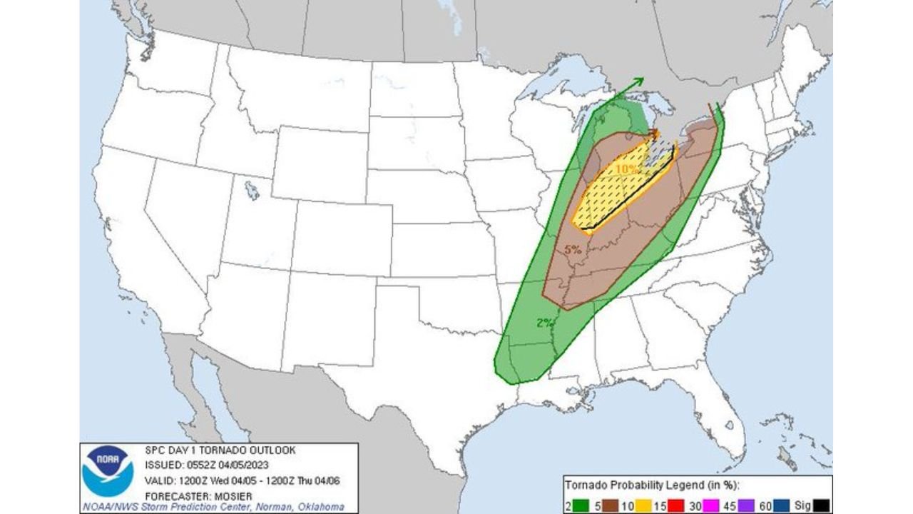
Enhanced Risk Zone Covered Multiple States
During that event, the Storm Prediction Center issued a Level 3 out of 5 Enhanced Risk, covering a wide corridor that included:
- Kentucky
- Tennessee
- Indiana
- Ohio
- Parts of Mississippi and Alabama
Within this zone, forecasts highlighted:
- A 5 percent tornado probability spread across a large area
- A 30 percent risk for damaging winds, indicating a strong likelihood of widespread impacts
This type of setup is particularly dangerous because it produces long-track storm lines capable of affecting multiple cities in a short period of time.
QLCS Systems Bring Fast-Moving and Hard-to-Track Tornadoes
Unlike isolated supercells, QLCS storms often produce quick spin-up tornadoes, which are:
- Short-lived but still capable of causing damage
- Embedded within heavy rain, making them harder to detect visually
- Moving rapidly, reducing reaction time for residents
This increases the overall risk level, even when tornado intensity remains relatively low.
Why This Pattern Is Being Watched Again
The reason this past event is being highlighted now is because similar atmospheric ingredients are being monitored once again, including:
- A broad warm and unstable air mass building northward
- Increasing wind shear through the mid-levels
- Potential for multiple embedded disturbances triggering storm lines
When these factors align, they can quickly evolve into a large-scale severe weather outbreak, especially across the Ohio Valley and Tennessee Valley corridor.
Key Areas That Should Stay Alert
Based on the previous impact zone and pattern recognition, the most critical areas to monitor include:
- Louisville and central Kentucky
- Western Kentucky communities
- Middle Tennessee including Nashville region
- Parts of southern Indiana and southern Ohio
These areas sit directly within the typical storm track corridor for QLCS events moving northeast.
Main Threats Residents Should Prepare For
If a similar setup develops again, the primary risks will include:
- Damaging straight-line winds capable of widespread outages
- Brief tornadoes embedded within storm lines
- Heavy rainfall leading to localized flooding
The combination of these threats makes this pattern particularly dangerous because impacts can occur quickly and across large areas simultaneously.
Why This Matters Right Now
This is not just a look back at a past event — it serves as a warning signal for how fast conditions can escalate when similar atmospheric setups return.
Even without a major tornado outbreak, QLCS-driven events can still produce significant damage, especially due to:
- The speed of storm movement
- The wide geographic coverage
- Limited time for warnings in rapidly evolving situations
What Residents Should Do Now
Residents across Kentucky, Tennessee, and the Ohio Valley should:
- Stay alert to severe weather forecasts and watches
- Ensure access to real-time weather alerts
- Have a plan in place for fast-moving storms, especially overnight
Preparedness is critical in these situations, as storm lines can develop and intensify quickly with little advance notice.
Stay with WaldronNews.com for continued updates as meteorologists monitor whether this dangerous storm pattern could re-develop across the Ohio Valley and Tennessee Valley in the coming days.