
Lake-Effect Snow Drives U.S. Seasonal Totals Past 100 Inches in Parts of New York and Michigan as Winter Pattern Stays Active
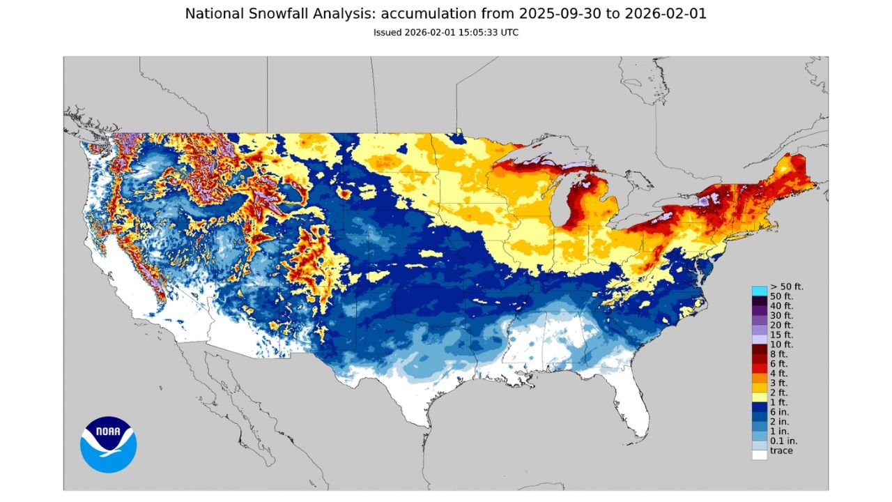
UNITED STATES — A relentless winter pattern continues to shape the 2025–26 cold season, with lake-effect snow pushing seasonal snowfall totals past 100 inches in parts of New York and Michigan, according to the latest National Snowfall Analysis released on February 1, 2026.
The updated national accumulation map shows widespread snow cover across the northern half of the country, with the most extreme totals concentrated downwind of the Great Lakes and across high-elevation regions of the West. In some lake-effect-prone communities, snowfall totals are now approaching or exceeding 127 inches for the season, driven by repeated bands of intense, moisture-rich snow.
Lake-Effect Snow Continues to Pile Up in the Great Lakes Region
The most striking feature on the snowfall map is the deep red and purple shading east of Lakes Erie and Ontario, signaling some of the highest snow totals in the United States so far this season.
Overnight, an additional 2.4 inches of snow was reported in areas impacted by persistent lake-effect bands. These narrow but powerful snow corridors have remained nearly stationary at times, allowing snowfall to accumulate rapidly over short distances.
Meteorologists note that cold Arctic air flowing across relatively warm lake waters continues to fuel these events, producing fluffy, high-ratio snowfall that adds up quickly even without major storm systems.
Snow Belt Communities Lead the Nation in Seasonal Totals
According to the national analysis covering September 30, 2025 through February 1, 2026, parts of:
- Western and Central New York
- Northern Lower Michigan
- Upper Peninsula of Michigan
have recorded seasonal snowfall totals well over 100 inches, placing them among the snowiest locations in the country this winter.
These totals are the result of frequent lake-effect episodes combined with a consistently cold pattern, preventing snowpack from melting between events.
Widespread Snow Coverage Across the Northern U.S.
Beyond the Great Lakes, the snowfall map highlights broad snow accumulation across the Plains, Midwest, Northeast, and interior West.
Key regional trends include:
- Moderate to heavy snowfall across the central Plains, stretching from the Rockies into the Midwest
- Significant mountain snow across the Sierra Nevada, Rockies, and Intermountain West
- Below-average snow coverage across the Deep South, where temperatures have been cold at times but precipitation limited
Even areas outside traditional snow belts have seen frequent light to moderate accumulations, reinforcing the persistent nature of this winter pattern.
Active Winter Pattern Shows No Signs of Slowing
Forecasters indicate that an active storm track remains in place, with additional opportunities for snow in the weeks ahead. Cold air remains firmly established across much of the northern U.S., allowing new snowfall to build on already impressive seasonal totals.
For lake-effect regions in particular, any renewed Arctic surges combined with favorable wind directions could quickly push seasonal snowfall even higher, especially in communities already well past the 100-inch mark.
What This Means Going Forward
With February just beginning, many snow-prone areas are on pace for above-average seasonal snowfall, especially where lake-effect snow remains a frequent visitor. Travel disruptions, snow removal challenges, and infrastructure strain are likely to continue in the hardest-hit regions.
Residents are encouraged to remain prepared as winter is far from over, and snowfall totals may continue to climb rapidly with little warning.
Have snowfall totals in your area already exceeded average levels this winter? Share your reports and stay connected with ongoing weather coverage at Waldronnews.com.