
Lake Michigan Cold Surge Pushes Warm Front South Across Illinois and Indiana, Shifting Tornado and Hail Threat Zones
CHICAGO, ILLINOIS — A sharp surge of cold air spilling south off Lake Michigan has dramatically altered the severe weather setup across northeast Illinois, northwest Indiana, and southwest Michigan this afternoon, forcing the warm front farther south and reshaping where the greatest storm risks may unfold.
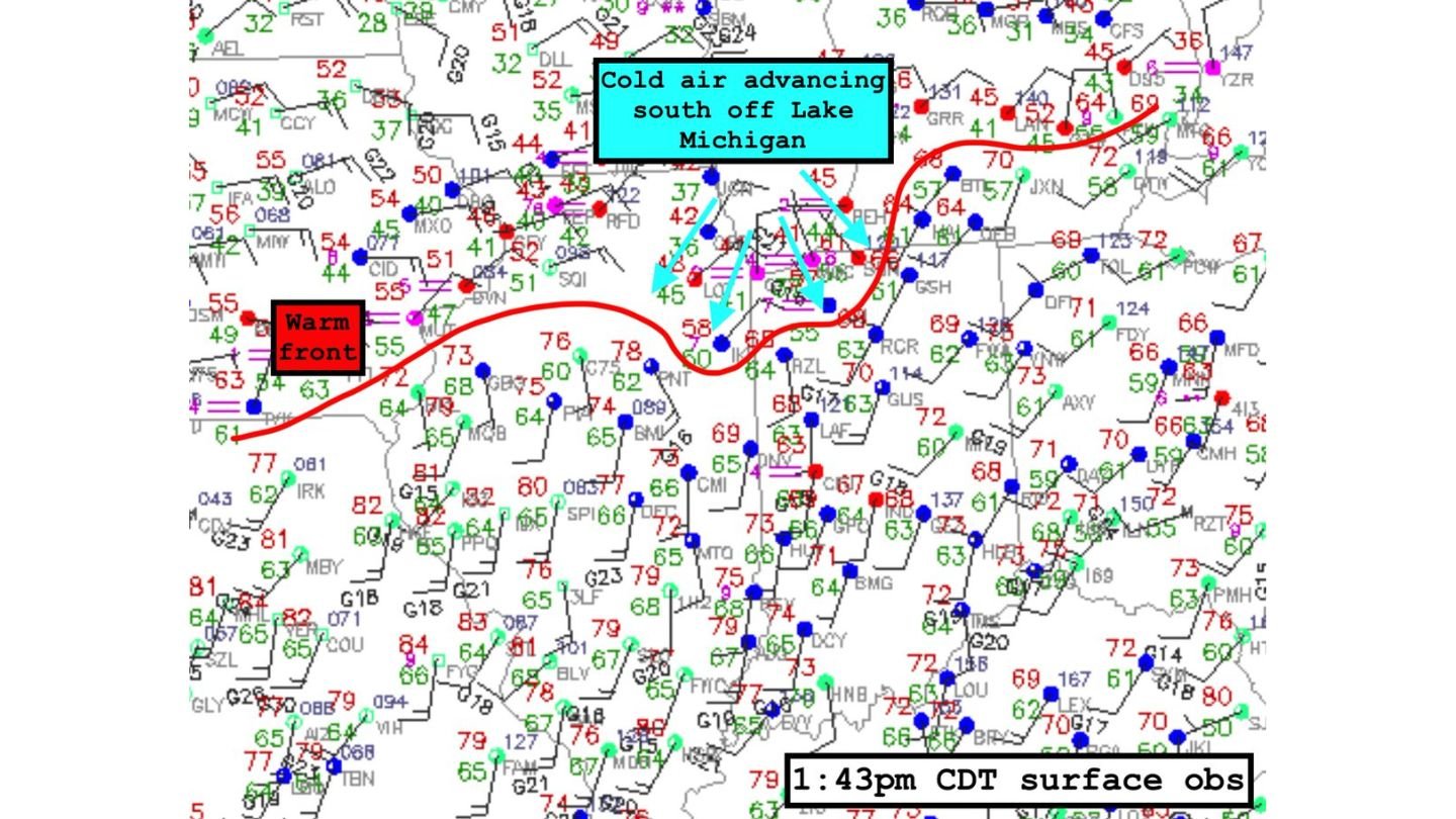
As of the 1:43 p.m. CDT surface observations, colder marine air has made a notable southward advance inland from Lake Michigan. Temperatures across portions of northeast Illinois and along the lakeshore have dropped into the 40s and even 30s in some locations, while areas just south of the boundary remain firmly in the 70s.
Warm Front Pushed South Across Northeast Illinois
The surface map shows the warm front arcing from northern Illinois eastward into northern Indiana and southern Michigan. However, the intrusion of lake-cooled air has reinforced the boundary and nudged it southward across parts of northeast Illinois.
This shift is critical.
If the cold air continues pressing inland, the Chicago metro would remain clearly on the cool side of the warm front. That would significantly reduce the tornado threat locally while increasing the potential for large hail in elevated storms that ride over the boundary.
Communities south of the boundary — where readings remain in the mid to upper 70s — would stay in the warm, unstable air mass more supportive of surface-based severe storms.
Supercell Behavior Could Be Affected
Forecasters are closely watching how storms interact with this boundary later today.
Supercells tracking along the warm front may encounter the cooler, more stable air to the north. If that happens, storms could transition from surface-based to elevated. That change would typically lower the long-track tornado potential but maintain or even enhance the risk for large hail.
The orientation of the boundary also matters. Because the warm front has locally arced southward across northeast Illinois, storms riding along it could ingest differing air masses over short distances, leading to rapidly changing storm structure and hazards.
Tornado Risk Dependent on Boundary Position
The tornado threat today hinges heavily on whether storms remain rooted in the warm sector south of the boundary or drift into the cooler air north of it.
- South of the warm front: Higher tornado potential, especially with strong wind shear.
- North of the warm front: Lower tornado risk, but large hail becomes more likely.
This type of boundary-driven setup can evolve quickly. A shift of even 20 to 30 miles in the warm front’s position can dramatically alter which communities face the highest risk.
What This Means for Arkansas Readers
While this setup is unfolding across Illinois and Indiana, the meteorological principles apply across the Midwest and into Arkansas during severe weather season. Boundaries like warm fronts and outflow edges frequently determine where tornadoes can form versus where storms remain elevated hail producers.
For residents in the affected Illinois and Indiana areas, close monitoring through the afternoon and evening will be essential. If the cold air surge weakens and the warm front lifts north again, tornado potential could increase quickly. If the cool air holds firm, the Chicago metro would likely remain on the lower-end tornado side of the threat.
WaldronNews.com will continue tracking how boundary placement evolves and how it influences storm intensity and hazards as the afternoon progresses.