
Late March Cold Risk Growing for Illinois, Indiana, Iowa, Minnesota and Wisconsin After Mild February Across the U.S., ECMWF Shows
UNITED STATES — While much of the country is expected to ride out a generally mild pattern through late February and into early March, new longer-range European model guidance is hinting at a potential colder turn during the back half of March, particularly across the central and northern United States.
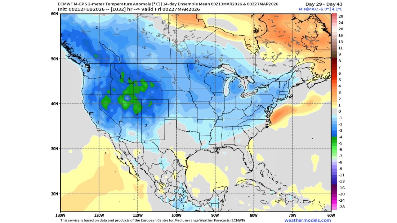
The latest ECMWF 14-day ensemble outlook (valid late March) shows below-average temperature signals expanding across large portions of the Midwest, Plains, Rockies, and parts of the interior Northeast — a setup that could resemble early spring patterns seen in 2023.
Mild Through Early March, But Cracks Emerging
Through the end of February and the first part of March, the broader signal remains relatively mild compared to seasonal norms across much of the eastern U.S.
Warmer anomalies are still favored near:
- The East Coast
- Parts of the Southeast
- Coastal Mid-Atlantic zones
However, that mild dominance begins to weaken as the calendar moves toward mid-to-late March.
Colder Anomalies Expanding Across the Heartland
The ensemble mean shows a noticeable cooling signal centered over:
- The Northern Plains (North Dakota, South Dakota)
- The Upper Midwest (Minnesota, Wisconsin)
- The Great Lakes region
- Portions of the Central Plains (Nebraska, Kansas)
- Interior Rockies (Wyoming, Colorado, Montana)
Temperature departures of 2 to 6 degrees below average are indicated across a broad region, with pockets potentially colder depending on how the upper-level pattern evolves.
The cooling signal also stretches into parts of:
- Iowa
- Illinois
- Indiana
- Michigan
- Western Pennsylvania
- Upstate New York
What’s Driving the Potential Shift?
Model guidance suggests a developing high-latitude blocking pattern and renewed colder air availability across Canada.
If that colder air reservoir becomes tapped, it could allow:
- Periodic late-season cold shots
- Increased storm track potential across the central U.S.
- More unsettled, wetter conditions in some regions
While this is not a guaranteed hard freeze scenario, it does introduce meaningful uncertainty into early spring expectations.
Agricultural Implications Could Mirror 2023
The pattern setup has similarities to early spring 2023, when colder and wetter conditions delayed planting in portions of the Midwest.
If this colder risk verifies, it could mean:
- Slight planting delays in corn and soybean regions
- Slower soil temperature recovery
- Increased precipitation chances depending on storm track alignment
Farmers across states like:
- Iowa
- Illinois
- Indiana
- Ohio
- Missouri
may want to monitor trends carefully as March progresses.
Southeast and Coastal Areas Less Impacted
The colder anomalies appear weaker toward:
- The Deep South
- Gulf Coast states
- Florida
- Immediate Atlantic coastline
While brief cool shots are possible, the strongest below-average signals remain concentrated across the nation’s interior.
Still Weeks Away — But Worth Watching
It’s important to note that this is a long-range ensemble outlook, not a locked-in forecast. However, the consistency of the colder risk appearing in late March runs suggests it cannot be dismissed.
For now:
- Late February into early March: Generally mild leaning
- Mid-to-late March: Growing risk of colder-than-average conditions across the Midwest and Plains
Waldronnews.com will continue tracking updates to see whether this colder March risk strengthens, weakens, or shifts geographically as new data arrives.