
Late-Week Northeast Winter Storm Could Bring Snow to Upstate New York and Northern New England, Icy Mix From Buffalo to Boston
UNITED STATES — Another winter system is taking shape for the Northeastern U.S. heading into mid-next week, with the potential for accumulating snow across interior New York and New England — and a messy rain/snow/ice mix stretching from western New York through southern New England.
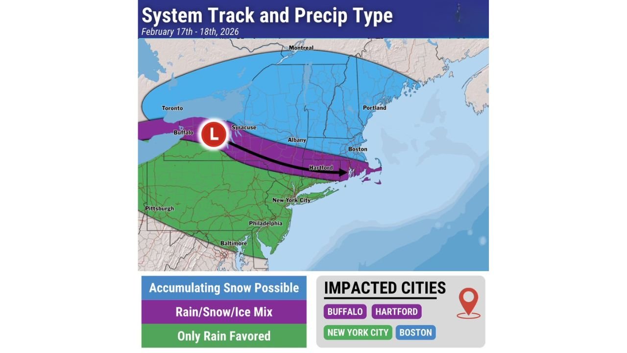
Forecast guidance for February 17–18, 2026 shows a developing low pressure system tracking from near Buffalo, New York, east-southeast across upstate New York and into southern New England. While exact precipitation types and amounts will depend heavily on the final storm track, early indications suggest travel disruptions could develop in several major metro areas.
Storm Track: From Buffalo Toward Southern New England
The projected system track places the center of low pressure near Buffalo, then sliding eastward across Syracuse, south of Albany, and toward Hartford and coastal Massachusetts.
This path is critical.
- Areas north of the track — including Syracuse, Albany, northern Massachusetts, Vermont, New Hampshire, and Maine — are currently favored for accumulating snow.
- Communities along and just south of the track — including Buffalo, Hartford, and possibly parts of interior Massachusetts — may sit in a rain/snow/ice mix zone.
- Farther south, including New York City, Philadelphia, Baltimore, and Pittsburgh, the setup currently favors mainly rain, though colder trends could shift that line.
Even small adjustments of 25–50 miles north or south could significantly change precipitation type for major population centers.
Snow Potential: Interior New York and Northern New England
Current projections highlight a broad swath of accumulating snow possible across:
- Central and northern New York
- Much of Vermont
- New Hampshire
- Interior Maine
- Northern and western Massachusetts
Cold air in place north of the low would support mostly snow, with the potential for plowable totals if the storm intensifies as it moves east.
While exact snowfall amounts remain uncertain at this range, the northern zone appears positioned for the most consistent snow signal.
Ice and Mixing Concerns: Buffalo to Hartford to Boston
The most delicate zone appears to stretch from Buffalo through Syracuse, Albany, and into Hartford and parts of eastern Massachusetts.
This corridor sits along the transition boundary between colder air to the north and milder air surging in from the south.
If warm air intrudes aloft while surface temperatures remain near or below freezing, this setup could produce:
- Freezing rain
- Sleet
- Rapid shifts between rain and snow
Even light ice accumulation can create hazardous road conditions and power line stress, particularly during commute hours.
For cities like Hartford and Boston, a minor shift north in the storm track would increase snow potential, while a shift south would bring more rain. The margin is narrow.
Major Metro Impacts: What About NYC and Philadelphia?
At this stage, New York City and Philadelphia are shown in the rain-favored zone. However, colder air wrapping into the system or a slightly stronger low could introduce mixing north and west of those cities.
For now:
- NYC: Mostly rain favored, but interior suburbs could see mixing if cold air holds.
- Philadelphia: Rain favored.
- Baltimore and Pittsburgh: Primarily rain.
Confidence is lower in exact precipitation type south of the storm track due to temperature sensitivities.
Why the Track Matters So Much
The projected low pressure path is positioned along a classic late-winter battleground between lingering cold air to the north and milder Atlantic air to the south.
The purple “mix zone” highlighted in forecast graphics underscores this sharp gradient. A subtle shift in:
- Jet stream positioning
- Surface low intensification
- Timing of cold air drainage
…could mean the difference between a cold rain and several inches of snow for cities like Albany, Hartford, or even Boston.
Travel Impacts Could Develop Mid-Week
If current trends hold:
- Upstate New York and interior New England could face snow-covered roads.
- Buffalo to Hartford corridor could see slick travel from mixed precipitation.
- Major airports including BUF, ALB, BDL, BOS, and possibly SYR could experience delays.
The system is still several days out, meaning forecast adjustments are expected.
Bottom Line
Another winter storm is on the radar for the Northeastern United States next week. Snow appears most likely across interior New York and northern New England, while a rain/snow/ice mix could stretch from Buffalo through Hartford and into southern New England.
The exact placement of the snow-to-mix line will determine who sees plowable snowfall and who deals with icy, messy travel conditions.
WaldronNews.com will continue monitoring track shifts and updated model guidance as we get closer to February 17–18.