
Level 3 Severe Storm Risk Targets Central Illinois and Northern Indiana Tuesday Night as Tornado, Large Hail, and Damaging Wind Threat Expands Across the Ohio Valley
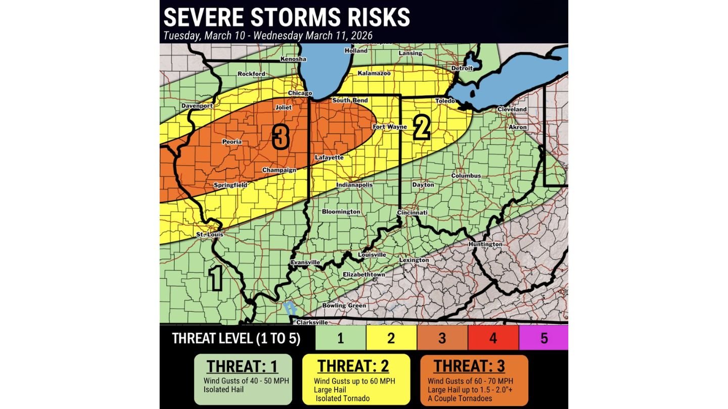
OHIO VALLEY — Severe storms are expected to erupt Tuesday evening and continue into early Wednesday morning across the Ohio Valley, with a concentrated Level 3 threat centered on central Illinois and northern Indiana.
Forecast guidance shows a corridor of heightened concern stretching from near St. Louis through Springfield, Peoria, Champaign, Joliet, and into the Lafayette and South Bend areas, before extending east toward Fort Wayne.
All severe hazards are on the table, including tornadoes.
Level 3 Risk: Central Illinois into Northern Indiana
The highest threat zone — categorized as Level 3 on a five-point scale — covers a broad swath of central Illinois into northern Indiana.
Cities within or near this elevated risk area include:
- Peoria
- Springfield (IL)
- Champaign
- Joliet
- Lafayette
- South Bend
In this zone, storms may produce:
- Wind gusts of 60–70 mph
- Large hail up to 1.5 to 2.0 inches or greater
- A couple of tornadoes
Storms in this corridor may organize into rotating supercells before potentially evolving into a larger complex overnight.
Level 2 Risk Extends into Indiana and Northwest Ohio
A Level 2 threat surrounds the higher-risk core and extends eastward through:
- Fort Wayne
- Portions of northern and central Indiana
- Areas approaching Toledo and parts of northwest Ohio
Within the Level 2 zone, wind gusts up to 60 mph and large hail remain possible, along with an isolated tornado.
Level 1 Risk South Toward the Lower Ohio Valley
Farther south into southern Illinois, western Kentucky, and parts of southern Indiana, a Level 1 risk indicates a lower but still present severe threat.
In this area, storms may bring:
- Wind gusts of 40–50 mph
- Isolated hail
While tornado potential is lower here compared to the Level 3 zone, strong wind and hail remain concerns.
Timing: Tuesday Evening into Early Wednesday
Storms are expected to intensify Tuesday evening as they track northeast from Missouri into Illinois and Indiana. The threat may persist into the overnight hours as activity pushes toward Ohio.
Overnight severe weather can be especially dangerous, as many people are asleep when warnings are issued.
All Hazards on the Table
Forecasters emphasize that this is not a one-hazard event. The environment supports:
- Damaging straight-line winds
- Large hail
- Tornado development
The combination of instability and wind shear will determine how quickly storms organize and whether discrete cells can form ahead of any larger line.
What Residents Should Do
Residents across central Illinois, northern Indiana, and parts of northwest Ohio should:
- Have multiple ways to receive warnings
- Review shelter plans in advance
- Charge mobile devices before storms arrive
The highest concern lies across central Illinois into northern Indiana, where the Level 3 zone indicates the greatest potential for impactful severe weather.
WaldronNews.com will continue monitoring updates as this severe weather threat unfolds across the Ohio Valley Tuesday night into early Wednesday.