
Light Snow Showers Stretch From Upstate New York to Maine as Spotty Coatings Possible Across Albany, Boston, and Montreal Region
Albany, New York — Scattered light snow showers are drifting across parts of upstate New York, Vermont, New Hampshire, Maine, and southern Quebec today, bringing the potential for brief bursts of snow but little in the way of widespread accumulation. Forecasters say some communities could see a light coating, while others may see nothing at all.
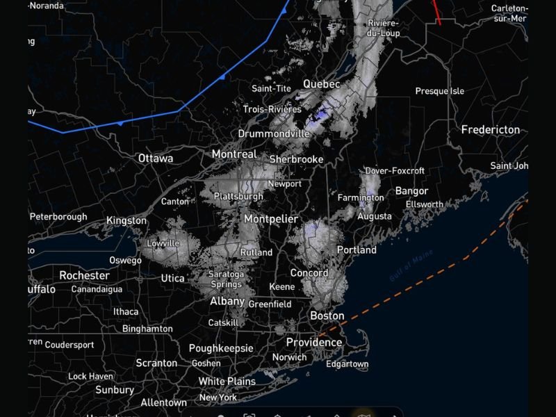
Radar imagery shows narrow bands of snow stretching from near Utica and Albany northeast through Montpelier, Sherbrooke, Montreal, and into Quebec, with additional scattered activity near Portland, Concord, and Boston. The system appears disorganized and patchy, meaning snowfall totals will vary significantly from town to town.
What Happened and When
Snow showers began developing earlier today as a weak disturbance moved through the region. The activity is scattered rather than part of a major winter storm, leading to on-and-off snowfall across several states.
Communities including Albany, Saratoga Springs, Rutland, Montpelier, and Plattsburgh have reported occasional light snow, while areas farther east such as Portland and Concord have seen intermittent flurries. In Boston and Providence, radar indicates lighter bands approaching or brushing the region, though temperatures near the coast may limit accumulation.
The pattern suggests snow showers will remain hit-or-miss through the day, tapering gradually by evening as the disturbance shifts eastward.
Areas Most Likely to See a Coating
The highest likelihood of a light accumulation appears inland and at higher elevations. Areas around Montpelier, Rutland, Sherbrooke, and parts of western Maine could see up to a dusting or light coating on grassy and elevated surfaces.
Lower elevations and urban centers such as Albany and Boston may only experience brief bursts of snow that melt quickly on contact, especially on treated roadways. Temperatures are marginal in some locations, reducing the risk of widespread travel issues.
Forecasters emphasize that this is not a significant winter event. However, brief heavier snow showers could temporarily reduce visibility, particularly along portions of Interstate 87, Interstate 89, and Interstate 95.
Travel and Safety Considerations
While widespread impacts are not expected, drivers should remain cautious during periods of heavier snow showers. Sudden reductions in visibility and slick spots can develop quickly, especially on untreated secondary roads and bridges.
Residents are advised to:
- Allow extra stopping distance if encountering snow-covered patches
- Use headlights during snowfall for improved visibility
- Monitor local forecasts for updated conditions
Because snowfall totals will vary widely, some neighborhoods may see no accumulation while others a few miles away pick up a light coating.
What Comes Next
Today’s snow activity serves as a brief pause before a potentially busier weather pattern ahead. Meteorologists note that while this system is weak, more active weather could develop later in the week.
For now, the region is experiencing what many describe as a typical late-winter scattered snow day—more of a nuisance than a disruption. The key takeaway is variability: it might snow lightly, or it might not accumulate at all, depending on location and timing.
Residents across New York, Vermont, New Hampshire, Maine, Massachusetts, and southern Quebec are encouraged to stay informed and monitor local weather updates throughout the day.
Follow WaldronNews.com for continued coverage on regional weather developments and upcoming forecast changes that may affect travel and daily routines.