
Louisiana, Mississippi, Alabama, Georgia, South Carolina, and North Carolina Brace for Cold Blast With Spotty Snow Chances This Weekend
LOUISIANA — A late-week cold surge is setting the stage for an unusually wintry stretch across the Gulf Coast and Southeast, including a low-but-not-zero chance of snow Saturday night for parts of southeast Louisiana and southern Mississippi, followed by a separate “watch-the-track” winter setup for the Carolinas on Sunday. Even where snow doesn’t fall, the bigger headline for many communities will be biting wind chills, icy spots, and travel disruptions if precipitation overlaps the coldest air.
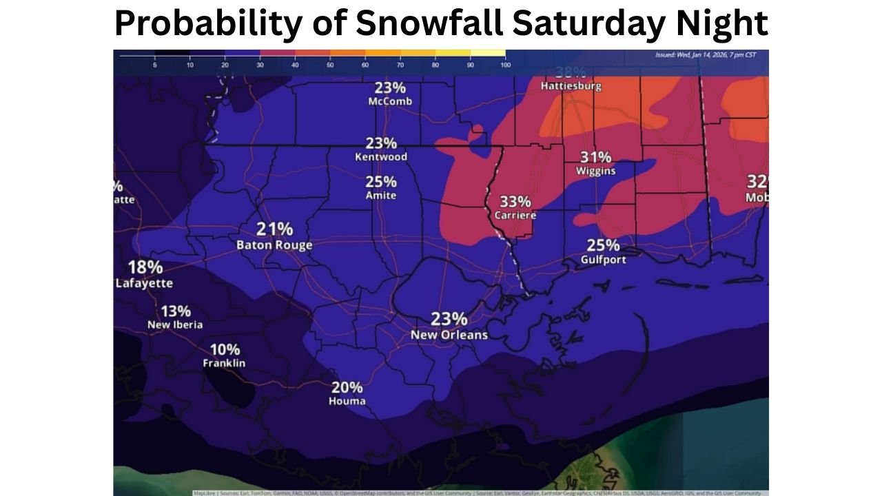
What the Snow Map Shows for Louisiana and Mississippi Saturday Night
Forecast guidance highlighted in the latest probability map suggests a low chance (generally around 10% to 30%) of snowfall Saturday night across southeast Louisiana and southern Mississippi. The signal is not widespread or guaranteed, but it’s enough to keep emergency managers and weekend travelers paying attention because it won’t take much snow or a brief burst of sleet to create slick bridges and surprise patches of ice this far south.
Several labeled probabilities on the map cluster in the “low chance” range, including:
- New Orleans, Louisiana: 23%
- Baton Rouge, Louisiana: 21%
- Houma, Louisiana: 20%
- Lafayette, Louisiana: 18%
- New Iberia, Louisiana: 13%
- Franklin, Louisiana: 10%
- Amite, Louisiana: 25%
- Kentwood, Louisiana: 23%
- McComb, Mississippi: 23%
- Gulfport, Mississippi: 25%
- Wiggins, Mississippi: 31%
- Carriere, Mississippi: 33%
- Near Hattiesburg, Mississippi: upper 30% range
- Near Mobile, Alabama: low 30% range shown at the edge of the map
Those numbers do not mean everyone in those cities sees accumulating snow. They indicate the chance that snow occurs at all, and in Gulf Coast setups, the difference between cold rain and wet snow can come down to tiny shifts in temperature profiles and timing.
Why This Setup Is Tricky in the Deep South
The Deep South often sits near the “rain/snow line” in winter events, and that’s exactly why confidence stays limited in a 10–30% scenario. If the cold air arrives a few hours late, precipitation falls as rain. If the cold air is in place early and moisture is timed correctly, brief snow showers or a rain/sleet mix can develop, particularly overnight when temperatures drop.
Even if accumulations are minor, impacts can be outsized because:
- Road treatment and driver expectations aren’t the same as in northern states.
- Bridges and overpasses cool faster than the ground and can glaze first.
- A quick burst of precipitation can create short-lived but dangerous conditions.
Georgia and South Carolina Could See Wind Chills Drop Into the Teens and Lower 20s Friday Morning
Ahead of the weekend snow talk, the immediate concern for parts of the coastal Southeast is dangerously cold wind chills. A wind chill outlook for the region indicates the coldest conditions are expected late Thursday night into Friday morning, with wind chills dropping into the teens to lower 20s.
The guidance also notes a meaningful probability of wind chills hitting 20°F or lower, with the highest chances inland (around the 60%–70% range) and lower—but still notable—odds closer to the coast (roughly 20%–50%). In practical terms, that means a wide area of Georgia and South Carolina could wake up to a morning that feels far colder than the thermometer suggests.
This is the kind of cold that can quickly become dangerous for people without adequate heat, and it can also stress infrastructure. Residents are urged to:
- Check on neighbors, especially seniors and anyone without reliable heating
- Bring pets indoors or provide safe, insulated shelter
- Protect pipes (wrap exposed lines and let faucets drip where needed)
Sunday’s Carolinas System: A Different “Beast,” With Snow Chances Still Evolving
A separate winter weather setup is being watched closely for South Carolina and North Carolina on Sunday, described as highly sensitive to storm track and timing. The core idea is a classic cold-season combo: cold energy diving south, moisture returning from the Gulf, and low pressure developing offshore. Small shifts in where the low forms and how quickly it intensifies can decide who sees flurries, a cold rain, or a more meaningful burst of snow.
Ensemble guidance highlighted in the graphics suggests a roughly 20%–30% chance of at least 1 inch of snow in parts of the region, with example probabilities shown as:
- Myrtle Beach, South Carolina: 16%
- Florence, South Carolina: 26%
- Lumberton, North Carolina: 32%
Those odds point to some potential, but not a locked-in storm. The takeaway for drivers and families planning Sunday travel is simple: if precipitation arrives while temperatures are near freezing, even light snow can create localized slick spots, especially on untreated roads.
What to Watch Over the Next 48–72 Hours
Because these are timing-dependent events, the most important updates will come from how the cold air and moisture line up. Key things to monitor include:
- Whether overnight temperatures fall fast enough for snow versus rain
- The exact placement of the heaviest precipitation band (especially near the Gulf Coast and along the Carolinas)
- Any late changes in wind direction that can shift storm track and temperature profiles
Bottom Line: Cold Is The Certainty, Snow Is The Wildcard
For Louisiana, Mississippi, and Alabama, the weekend forecast leans toward a cold pattern with a low chance of snow Saturday night, but enough risk to warrant caution on bridges and early-morning roads. For Georgia, South Carolina, and North Carolina, the immediate story is dangerous wind chills Friday morning, followed by a still-developing winter setup Sunday where small shifts could make a big difference in who sees accumulating snow.
What are you seeing where you live — are you preparing for snow, ice, or just the bitter cold? Share what conditions look like in your area and keep following Waldron for the latest updates as this forecast sharpens.