
Louisiana, Mississippi, Alabama, Georgia, Tennessee, and the Carolinas Under Slight Risk as SPC Expands Thunderstorm and Severe Weather Corridor Through Friday Morning
SOUTHEAST UNITED STATES — A broad corridor of thunderstorms, including areas with severe weather potential, is expected to impact much of the Deep South and Southeast from tonight through Friday morning, according to the latest Storm Prediction Center outlooks.
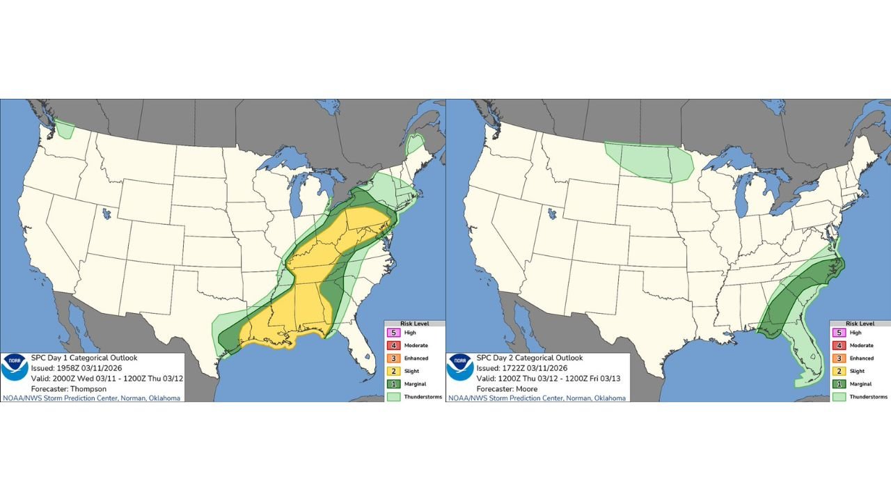
Updated categorical maps show a multi-state stretch under a Slight Risk for severe storms, with additional Marginal Risk areas expanding both northward and eastward as the system progresses.
Day 1 Outlook: Gulf Coast to Ohio Valley in the Risk Zone
For tonight into early Thursday (valid through 12Z Thursday), the SPC highlights a pronounced Slight Risk (Level 2 of 5) extending from:
- Southeast Texas
- Louisiana
- Mississippi
- Alabama
- Western and central Georgia
- Western Tennessee
- Western Kentucky
Surrounding this is a broader Marginal Risk area covering portions of:
- The Ohio Valley
- The central Gulf Coast
- Parts of the Mid-Atlantic
This setup suggests thunderstorms capable of producing damaging winds and isolated severe reports will be most likely along the Gulf Coast states and into the lower Mississippi Valley.
Most Active Period: Tonight into Thursday
The outlook notes that the more active and widespread period is expected tonight into Thursday, as a strong frontal system pushes eastward.
States most likely to see stronger storms during this window include:
- Louisiana
- Mississippi
- Alabama
- Georgia
The alignment of the Slight Risk corridor indicates enhanced instability and wind shear overlapping along this axis — ingredients favorable for organized thunderstorms.
Day 2 Outlook: Storms Shift Toward the East Coast
By Thursday into Friday morning (valid 12Z Thursday to 12Z Friday), the severe threat shifts eastward.
The Day 2 outlook shows a Marginal Risk stretching along:
- Coastal Georgia
- South Carolina
- North Carolina
- Eastern Florida
This suggests the system will continue producing thunderstorms as it approaches the Atlantic seaboard, though the overall severe intensity may decrease compared to the prior day.
Meanwhile, a separate thunderstorm area is noted across portions of the northern Plains, though without elevated severe categorization at this time.
What This Means for Affected States
Residents across the Deep South and Southeast should be prepared for:
- Strong to locally damaging wind gusts
- Heavy downpours
- Frequent lightning
- Isolated severe storm reports
The highest confidence for organized severe potential remains from Louisiana through Alabama and into Georgia during the overnight and early Thursday hours.
Staying Weather Aware
With storms expected during nighttime hours for some locations, visibility and response time may be reduced. Residents are encouraged to:
- Keep weather alerts enabled
- Monitor local forecasts
- Have multiple ways to receive warnings
As the system moves east into the Carolinas and Florida by Thursday night into Friday morning, thunderstorm chances will continue, though the primary severe window appears focused earlier across the Gulf Coast states.
Stay with WaldronNews.com for continued updates as this multi-state thunderstorm corridor evolves through Friday morning.