
Major U.S. Weather Shift Announced: Cold Front Clears Storms and Brings Dry Easter Relief Across Midwest and Central States
UNITED STATES — A significant weather shift is now being signaled across the country as forecast models come into strong agreement on the progression of a cold front, bringing an end to recent rounds of heavy rain and storms while setting up a much calmer Easter period for large parts of the nation.
This developing pattern is especially important for residents across the Midwest and Central United States, where conditions are expected to noticeably improve after the front passes.
Strong Model Agreement Signals Confidence in Forecast
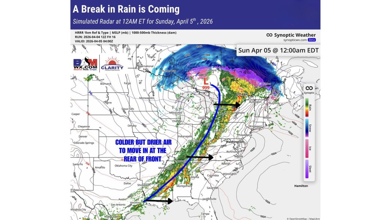
Weather guidance shows a consistent solution across multiple models, indicating that the cold front will steadily move eastward, pushing a band of rain and thunderstorms out of the central U.S.
This level of agreement increases confidence in the following trends:
- Storms exiting the Midwest and Central U.S. by late Saturday into early Sunday
- A well-defined line of rain and storms shifting toward the East Coast
- Rapid clearing conditions developing behind the front
This means the recent active weather pattern will not linger into Easter Sunday for much of the central part of the country.
Rain and Storms Shift East Overnight
As the system advances:
- A narrow but active line of showers and thunderstorms will extend from the Gulf Coast through the Ohio Valley into the Northeast
- Areas along this line may still experience brief heavy rain and gusty winds
- The system continues progressing east through the night into early Sunday
Cities across the Mississippi Valley, Great Lakes, and central Plains will see precipitation ending from west to east.
Drier and Cooler Air Moves In Behind the Front
Once the front passes, a noticeable air mass change will follow:
- Cooler temperatures replace the earlier warm conditions
- Humidity levels drop significantly
- Skies begin to clear across much of the Midwest and Central U.S.
This shift brings a much more stable environment, reducing the risk of additional storm development.
Midwest and Central U.S. Set for Calmer Easter
The biggest takeaway from this setup is the timing.
By Easter Sunday:
- Much of the Midwest, including states like Illinois, Indiana, Missouri, Iowa, and surrounding areas, will be dry and calmer
- The Central U.S., including parts of Kansas, Oklahoma, and Texas, will also experience improving weather conditions
- Outdoor plans, travel, and gatherings across these regions are less likely to be impacted by storms
This marks a clear transition from recent severe and unsettled conditions to a more quiet and manageable weather pattern.
East Coast Still Watching the System
While the central part of the country improves, attention shifts east:
- The Appalachians, Southeast, and Northeast will see the main band of rain and storms move through
- Timing suggests impacts continuing into Sunday for some eastern areas
- Conditions gradually improve later as the front exits offshore
Final Outlook
This cold front represents a turning point in the current weather pattern, effectively sweeping away storms and replacing them with cooler, drier air across the central United States just in time for Easter.
For millions across the Midwest and Central regions, this means a much-needed break from active weather and a more favorable holiday forecast.
Stay with WaldronNews.com for continuing updates as this system progresses and regional conditions evolve.