
Major Winter Storm to Blanket Western U.S. Mountains With Up to 4 Feet of Snow From Washington to Colorado
Boise, Idaho — A powerful Pacific storm system is set to sweep across the western United States beginning Friday, bringing heavy mountain snow and dangerous travel conditions through the weekend. Meteorologists say several states — including Washington, Oregon, Idaho, Montana, Utah, Wyoming, and Colorado — could see 2 to 4 feet of snow in higher elevations, with additional systems expected early next week.
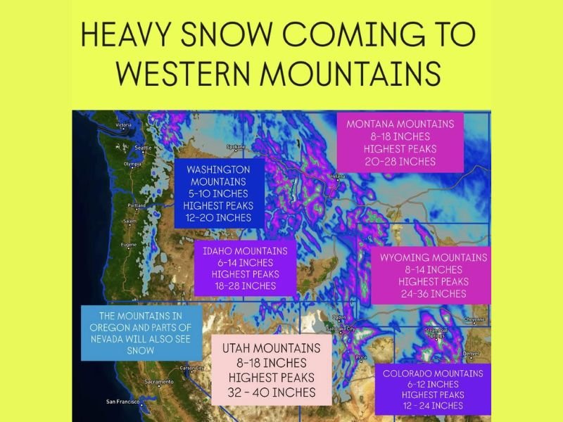
Heavy Snow Expands Across the Western Mountains
The storm will move inland Friday, spreading widespread snow from the Cascades and Sierra Nevada to the Rockies. The National Weather Service reports that moisture-rich Pacific air will collide with colder air spilling from the north, creating ideal conditions for intense snowfall and whiteout conditions at higher altitudes.
In the Washington mountains, totals of 5–10 inches are expected, with the highest peaks reaching 12–20 inches. Farther south, Oregon’s mountain ranges and nearby Nevada peaks will also receive significant accumulations through the weekend.
Heaviest Totals Expected in Utah and Idaho
The Wasatch Range in Utah and the central Idaho mountains are expected to bear the brunt of the storm, with 8–18 inches common and locally up to 40 inches at the highest peaks.
Forecasters describe the incoming storm as “multi-day and high-impact,” with strong winds contributing to drifting snow and dangerous visibility.
In Idaho, heavy snow will blanket the Salmon River and Boise mountain regions, where totals could reach 18–28 inches on the tallest summits.
Northern Rockies and High Plains Also Impacted
The snow event will stretch well into the northern Rockies, affecting Montana and Wyoming through Sunday.
- Montana mountains could see 8–18 inches, with 20–28 inches on the highest peaks.
- Wyoming will experience similar totals, with 6–14 inches widespread and up to two feet in elevated zones near Jackson Hole and the Teton Range.
Even some valley locations across the northern U.S. Rockies may see light accumulations, marking one of the most widespread early-season snow events so far this winter.
Colorado to See Heavy Mountain Snow Through Sunday
In Colorado, snow will begin Friday night and continue through the weekend, bringing 6–12 inches to most mountain ranges and up to 24 inches at the highest elevations. Ski resorts across the Rockies are preparing for excellent early-season conditions as fresh powder piles up heading into next week.
Travel Hazards and Outlook
Officials are warning that travel across major passes — including Snoqualmie Pass (WA), Lookout Pass (ID/MT), and I-70 in Colorado — may become difficult or impossible at times. Gusty winds, blowing snow, and freezing temperatures will combine to create whiteout conditions in exposed areas.
Meteorologists note that another Pacific system may arrive early next week, bringing another round of snow to many of the same regions.
For continuous weather updates, snowfall totals, and road advisories across the western United States, follow WaldronNews.com for verified reports throughout the weekend.