
Major Winter Storm to Bring 6–12 Inches of Snow Across Northcentral States and the Great Lakes, Forecast Models Show
UNITED STATES — A significant winter storm is becoming increasingly likely early next week, with new forecast data indicating that 6–12 inches of snow could fall across a widespread region stretching through the Northern Plains, Upper Midwest, and Great Lakes. States most likely to be impacted include Montana, North Dakota, South Dakota, Minnesota, Wisconsin, Michigan, Iowa, Illinois, Indiana, and Ohio.
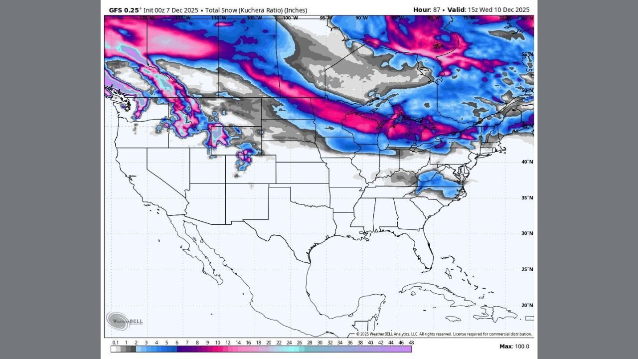
The latest GFS snowfall projections show a long corridor of heavy snow developing from the Rocky Mountains through the Northcentral U.S. and into the Great Lakes region, suggesting one of the first large-scale winter storms of December may be approaching.
Snowfall Map Highlights a Broad Impact Zone
The forecast map shows a wide swath of deep pink and purple shading, indicating snow totals that could exceed 10 inches in parts of:
- Montana & Wyoming
- North Dakota & South Dakota
- Northern Minnesota
- Northern Wisconsin
- Upper and Northern Lower Michigan
Meanwhile, lighter but still notable snowfall totals are projected across Iowa, Illinois, Indiana, and Ohio, depending on how the storm ultimately tracks.
Forecasters emphasize that the snow band is unusually long and continuous, stretching from the Pacific Northwest to the Great Lakes — a sign of strong upper-level support driving the system eastward.
Travel Concerns Rising Ahead of Storm’s Arrival
With snow expected to begin Monday and continue into Tuesday, the storm may cause:
- Dangerous driving conditions due to accumulating snow
- Reduced visibility from snowfall and blowing snow
- Flight delays across major Midwest airports
- Localized power outages in heavier wet-snow regions
Cities such as Bismarck (ND), Fargo (ND), Minneapolis (MN), Duluth (MN), Green Bay (WI), Grand Rapids (MI), and Cleveland (OH) could experience moderate to major travel disruptions.
Why Meteorologists Are Monitoring This Closely
Meteorologists point to a strong upper-level disturbance moving in from the Pacific Northwest. This energy will interact with colder air mass settling over the north, creating ideal conditions for a widespread snow-producing system.
The long, narrow swath of heavy snow is typical of early-season winter storms that ride the boundary between warm and cold air masses. While confidence is growing, experts caution that snow totals and exact placement may shift as the system approaches.
Still, the consistency of modeling over recent runs suggests that the Northcentral U.S. and Great Lakes should prepare for a notable early-week snowfall event.
Residents Urged to Monitor Forecast Updates
Local forecasters recommend preparing for:
- Slippery roads
- Longer commutes
- Cold wind chills accompanying the snowfall
- Possible school delays or closures depending on final totals
The storm has the potential to affect millions from Montana to Ohio, making early preparation essential.
Stay Updated With Waldron News
For breaking weather alerts, local snowfall breakdowns, and state-by-state impact forecasts, follow WaldronNews.com. Our team will continue monitoring updated models and provide new information as the storm approaches.