
Manhattan Neighborhood Map Highlights Over 50 Historic And Modern Areas Across New York City So Residents And Visitors Can Better Understand Local Districts
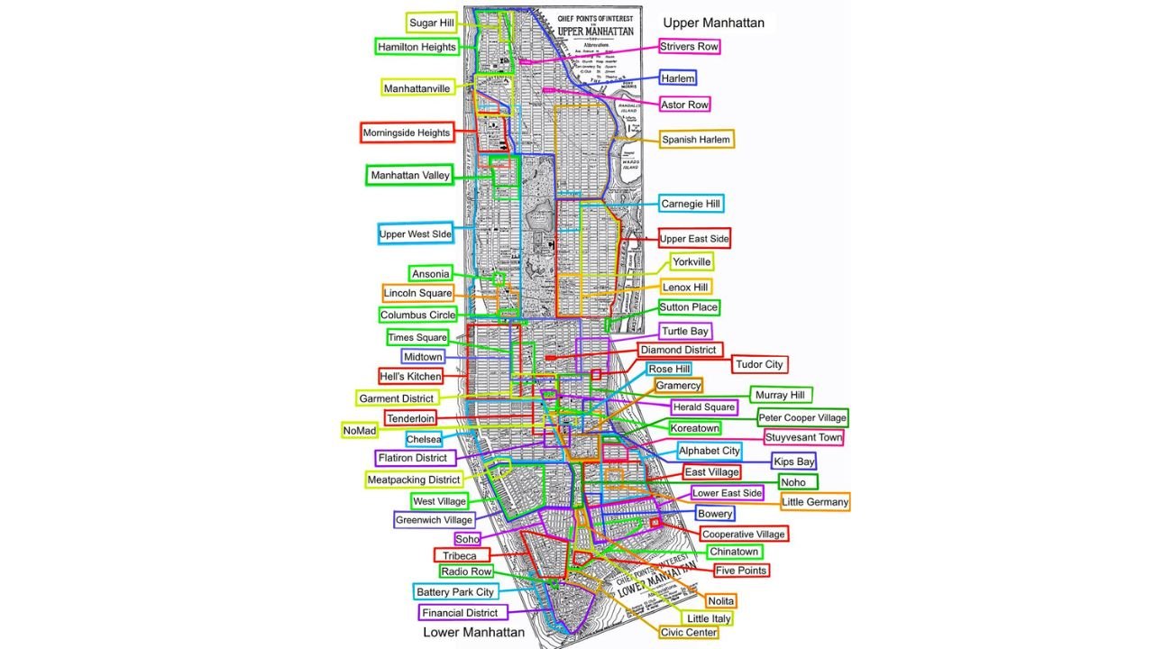
NEW YORK CITY, NY — A detailed neighborhood map of Manhattan is offering a comprehensive look at how one of the world’s most iconic urban areas is divided into dozens of distinct communities, each with its own identity, history, and boundaries.
The map focuses specifically on Manhattan, one of New York City’s five boroughs, and outlines both well-known and lesser-known neighborhoods from Upper Manhattan down to Lower Manhattan.
Upper Manhattan Features Historic And Cultural Neighborhoods
In the northern section of Manhattan, several culturally rich and historic areas are highlighted, including:
- Harlem
- Spanish Harlem
- Hamilton Heights
- Washington Heights
- Sugar Hill
- Manhattanville
These neighborhoods are known for their deep cultural roots, historic architecture, and long-standing communities that have shaped New York City’s identity.
Central Park Divides Upper West Side And Upper East Side
Moving south, the map clearly shows how Central Park acts as a dividing line between two of Manhattan’s most recognized areas:
- Upper West Side
- Upper East Side
Within and around these regions, additional neighborhoods are identified, such as:
- Lincoln Square
- Carnegie Hill
- Yorkville
- Lenox Hill
These areas are known for residential living, cultural institutions, and proximity to major city landmarks.
Midtown Manhattan Packed With Iconic Locations
The central portion of the map highlights Midtown Manhattan, one of the busiest commercial districts in the world.
Key neighborhoods and districts include:
- Times Square
- Hell’s Kitchen
- Garment District
- Koreatown
- Herald Square
- Midtown East and West
This area serves as the economic and entertainment hub of the city, with dense development and heavy daily foot traffic.
Downtown Areas Show Dense Neighborhood Overlap
As the map moves into Lower Manhattan, the density of neighborhoods increases significantly, with many smaller districts packed closely together.
Highlighted areas include:
- Chelsea
- Flatiron District
- Greenwich Village
- West Village
- SoHo
- Tribeca
These neighborhoods are known for their mix of residential, commercial, and cultural spaces, along with unique architectural styles.
Lower Manhattan Anchored By Financial And Historic Districts
At the southern tip of the island, the map identifies major historic and financial centers such as:
- Financial District
- Battery Park City
- Chinatown
- Little Italy
- Civic Center
These areas represent some of the oldest parts of New York City and remain central to its economic and cultural activity.
More Than 250 Neighborhoods Across New York City
While this map focuses only on Manhattan, it’s important to note that New York City as a whole contains more than 250 neighborhoods across its five boroughs:
- Manhattan
- Brooklyn
- Queens
- The Bronx
- Staten Island
This highlights the complexity and diversity of the city’s layout.
Why This Map Matters
Understanding neighborhood boundaries in Manhattan can help:
- Residents better navigate local communities
- Visitors explore areas beyond major tourist spots
- Provide context to the city’s cultural and historical divisions
Each neighborhood carries its own identity, contributing to the broader character of New York City.
Final Outlook
This detailed Manhattan neighborhood map provides a clear snapshot of how one borough is divided into dozens of unique areas, each playing a role in the city’s structure and daily life.
From Harlem to the Financial District, the map reflects the layered history and evolving landscape of New York City.
Stay with WaldronNews.com for more insights, maps, and updates covering cities and regions across the United States.