
Map Shows Hawaii to Scale With Mainland U.S., Revealing Just How Vast the Aloha State Really Is
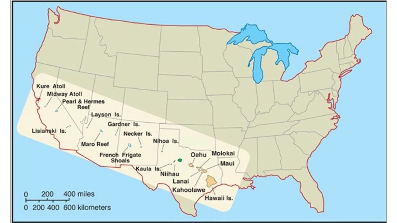
UNITED STATES — A newly highlighted map comparison is reshaping how many Americans visualize Hawaii, placing the island chain directly across the continental United States to show its true geographic scale.
Instead of the small inset commonly seen in classroom maps, the illustration stretches Hawaii from the West Coast across the Southwest and into the Southern Plains — revealing that the island chain spans a distance comparable to traveling from California to Texas.
Hawaii Is Far Larger Than Most Realize
The map places the Hawaiian Islands diagonally across the mainland U.S., beginning offshore of California and extending across:
- Nevada
- Utah
- Arizona
- New Mexico
- Texas
When drawn to scale, the chain reaches nearly to the Gulf Coast region.
This perspective demonstrates that Hawaii is not a compact cluster of islands — but a vast archipelago stretching more than 1,500 miles across the Pacific Ocean.
From Kure Atoll to the Big Island
The map labels numerous islands and atolls that are rarely seen in standard depictions, including:
- Kure Atoll
- Midway Atoll
- Pearl and Hermes Reef
- Laysan Island
- Gardner Island
- Necker Island
- Nihoa Island
- French Frigate Shoals
- Maro Reef
- Lisianeki Island
These northwestern islands extend far beyond the more commonly recognized main islands.
The primary inhabited islands shown include:
- Oahu
- Maui
- Molokai
- Lanai
- Kahoolawe
- Niihau
- Hawaii Island (The Big Island)
When positioned across the mainland map, the geographic footprint becomes strikingly clear.
A Different Way to Visualize Distance
Many U.S. maps shrink Hawaii into a small box in the lower-left corner, making the state appear far more compact than it truly is.
But when shown to scale:
- The westernmost islands align near California
- Central islands overlay parts of Arizona and New Mexico
- The Big Island reaches near Texas
This scale comparison highlights the immense stretch of ocean separating the islands and emphasizes Hawaii’s true size relative to the continental United States.
Why This Matters
Understanding Hawaii’s scale provides better context for:
- Weather systems that move across the island chain
- Marine and aviation travel distances
- Ecological diversity across different islands
- The geographic isolation between the Northwestern Hawaiian Islands and the main inhabited islands
It also illustrates why conditions can vary significantly from one island to another — the chain spans a distance equivalent to crossing multiple mainland states.
A Perspective Shift
The visual comparison serves as a reminder that traditional map insets can distort perception.
When placed accurately to scale, Hawaii is not a tiny dot in the Pacific — it is a sprawling island chain stretching across a distance comparable to a large section of the continental U.S.
For more geography insights, weather analysis, and breaking updates from across the country, stay connected with WaldronNews.com for continued coverage and in-depth reporting.