
March 2026 Drought Is Far Worse Than the Historic March 2012 Heat Wave as Over 1100 Daily Temperature Records Set Since March 1 Across Texas, Oklahoma, Kansas and the Central United States
UNITED STATES — March 2026 has been exceptionally hot — but the comparison to the last time the country saw a March this warm reveals something deeply alarming that goes beyond the heat itself. In March 2012, which was considered one of the most extraordinary warm March events in United States history, over 7,000 daily high temperature records were set across the country. In March 2026, the National Weather Service has confirmed that over 1,100 daily record highs have been set since March 1 — a lower raw number than 2012, but the critical difference between the two historic heat events is not the temperature records. It is the drought.
When March 2012 arrived, the drought situation across the United States was bad — but manageable in many regions. When March 2026 arrived, the drought situation was already significantly worse across vast portions of the central, southern and western United States before the heat wave even began. That starting point matters enormously for what comes next.
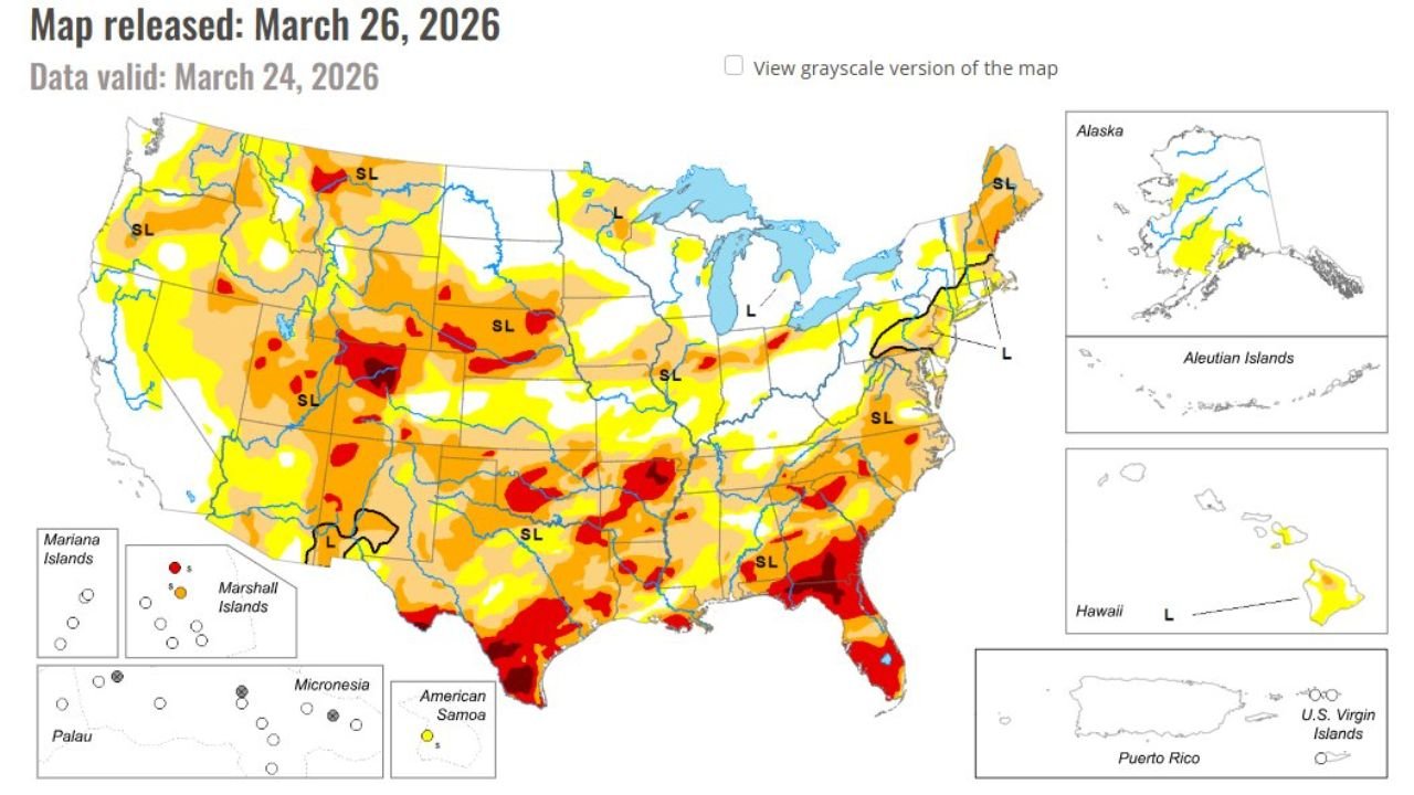
March 2012 vs March 2026 — What the Drought Maps Show
Comparing the US Drought Monitor from March 27, 2012 to the US Drought Monitor from March 24, 2026 tells the story clearly.
In March 2012, the worst drought — shown in dark red and maroon on the map — was concentrated primarily across Texas, Oklahoma and portions of the southern Plains, with moderate to severe drought spreading across parts of the Great Plains and Southeast. Large portions of the Midwest, Great Lakes, Northeast and Pacific Northwest were essentially drought-free.
In March 2026, the drought footprint is dramatically larger and more severe across a much wider area. Deep red and orange drought conditions — representing Extreme and Exceptional Drought — are spread across Texas, Oklahoma, New Mexico, Colorado, Kansas, Missouri, the Southeast and portions of the Pacific Northwest and Mountain West. There is virtually no region of the country that is completely free from at least abnormally dry conditions. The 2026 drought map is darker, broader and deeper than the 2012 map at the same point in the year — and the heat wave has already been running on top of it.
Why March, April and May Matter So Much Right Now
Here is the critical piece of context that makes the March 2026 situation particularly alarming for the months ahead. March, April and May are the single most important months of the entire year for rainfall across the central and eastern United States — east of the Rockies.
During summer, the jet stream retreats northward and large-scale storm systems that bring beneficial rainfall become much less frequent across Texas, Oklahoma, Kansas, Missouri, Tennessee, the Carolinas and surrounding states. The spring months — March, April and May — are the natural window when those storm systems are still active and can replenish soil moisture, recharge rivers and reservoirs and set up the land surface for the hot and dry summer ahead.
When spring is dry and hot, as March 2026 has been, the soil moisture that should be building heading into summer never materializes. Crops go into the ground in parched soil. Rivers and reservoirs head into summer already depleted. And when summer heat arrives — as it inevitably does across Texas, Oklahoma, Kansas and the central United States — there is no moisture buffer to moderate temperatures or slow the progression of drought.
The 2026 Setup Is Pointing Toward a Dangerous Summer
The combination of factors in place right now — a dry winter across the western snowpack, below-normal rainfall across the central and eastern United States, and a March heat wave running on top of an already severe drought — is setting the stage for what forecasters are describing as a dangerously hot and dry summer for large portions of the country.
Heightened fire risk is already a concern across Texas, Oklahoma, Kansas, New Mexico and the Southeast where drought is most intense and vegetation is stressed. As summer progresses and heat increases, the window for catastrophic wildfire conditions grows wider.
Extended intense drought is the other major concern. Without significant and repeated rainfall during April and May — the last real window before summer’s drying influence takes over — the drought across Texas, Oklahoma, Kansas, Missouri and the Southeast will deepen further through the summer months.
What This Means for Residents Across Texas, Oklahoma, Kansas and the Central United States
If you live in Texas, Oklahoma, Kansas, Missouri, Tennessee, Georgia, Alabama or the Carolinas — the drought situation in your area right now is worse than it was at the same point in 2012, which itself was followed by a brutal summer drought that devastated crops and stressed water supplies across much of the country.
April and May rainfall is now critically important for your region. Every significant rain event that falls between now and June is working to buy a small amount of time and moisture against what could be a very difficult summer ahead. Drought conditions that exist in March rarely disappear quickly — they tend to deepen and worsen through the summer unless spring delivers exceptional and widespread rainfall.
Water utilities, agricultural producers, wildfire preparedness agencies and emergency managers across the central and southern United States should be treating the current drought situation with the urgency it deserves — because if spring does not deliver, summer almost certainly will not either.
What to Watch Next
- April rainfall totals across Texas, Oklahoma, Kansas and the Southeast — the single most important weather variable for the coming summer outlook
- US Drought Monitor updates — whether drought conditions worsen or stabilize through April
- Wildfire activity across Texas, Oklahoma and New Mexico as spring winds and low humidity combine with drought-stressed vegetation
- Reservoir levels across Texas and Oklahoma — the Colorado River lakes, Lake Texoma and other major water storage systems heading into summer
- Summer 2026 seasonal outlook from NOAA — whether the agency raises the probability of above-normal heat and below-normal precipitation for drought-affected states
WaldronNews.com will continue tracking the 2026 drought situation across Texas, Oklahoma, Kansas, Missouri and the Southeast and provide updates as spring rainfall patterns develop through April and May.